Home / Land, dacha, construction / Documents and legislation / Land plot
Back
Published: 02/27/2018
Reading time: 13 min
0
3588

In the process of choosing a land plot, it is worth paying attention to such a parameter as the territorial zone of the land plot. It is on this basis that the type of permitted use of the site and the possibility of developing it with specific objects are determined.
- Territorial zones of land plots: concept and legislation
- Types of zones
- How to find out the territorial zone of a land plot
- If you need to change the zone of the land plot
What are the territorial zones?
All land plots for which regulations have been adopted, according to the Town Planning Code, belong to one of the territorial zones. There are 8 main categories, there are also auxiliary ones. Each has its own letter designation: this is what is used on urban zoning maps and other documents.
The types and composition of territorial zones are described in detail in the GRK. We provide brief information in the table.
| AND | Residential | Here you can build individual residential, low-rise, block and multi-storey buildings. Also in this territorial zone the construction of auxiliary facilities providing social infrastructure is permitted. We are talking about preschool educational institutions, schools, public utilities, clinics, hospitals, pharmacies, parks, public gardens, grocery stores, etc. This territorial zone has a large number of subzones. For example, Zh-1 is intended for low-rise buildings, Zh-2 - for low- and mid-rise buildings, Zh-3 - for mixed buildings with buildings no more than 5 floors high. |
| D | Social and business | Suitable for placing any commercial and social facilities. |
| P | Production | Manufacturing, utility, and warehouse enterprises are located in this zone. The construction of social facilities and commercial real estate is also permitted. |
| I, T | Engineering/transport infrastructure | Required for engineering, transport infrastructure and railway transport facilities, as well as facilities serving them. |
| R | Recreational | Needed for the placement of public gardens, parks, sports complexes, recreation and tourism facilities. |
| WITH | Agricultural | Suitable for pastures, gardens, country houses. |
| K/K3 | Special purpose/military/regime areas | Cemeteries are organized here, waste incineration plants are built, military facilities, prisons, etc. are located here. |
Territorial zones run along the boundaries of roads, streets, red lines, boundaries of land plots and natural objects. It is unacceptable for a land plot to be broken up and belong to several territorial development zones at once.
Transport and engineering infrastructure
These territorial zones are used for the placement and operation of structures and communications for road, rail, sea, river, pipeline, air transport and communications, as well as service equipment. A prerequisite for the location of objects is the observance of certain distances between them and residential areas, recreational and public-business complexes, as well as other requirements aimed at preventing negative impacts on the environment. If objects act as sources of danger or harmful effects on the health of citizens, they are transferred beyond the boundaries of the territorial zones of residential development. Improvement of areas intended for the placement of transport and engineering infrastructure facilities is carried out by their owners. The responsibilities of the subjects also include the creation of sanitary protection zones.
How to find out the territorial zone?
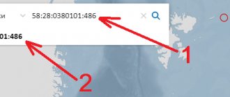
To do this, you can go several ways. The simplest one is to open the public cadastral map of Rosreestr. On it you need to find a plot using a map or cadastral number and look at the information you are interested in.
The second way is to find Moscow territorial planning documents and look at them for the division into territorial zones. For example, in the general plan of Moscow, functional zones are indicated separately on the map by district:
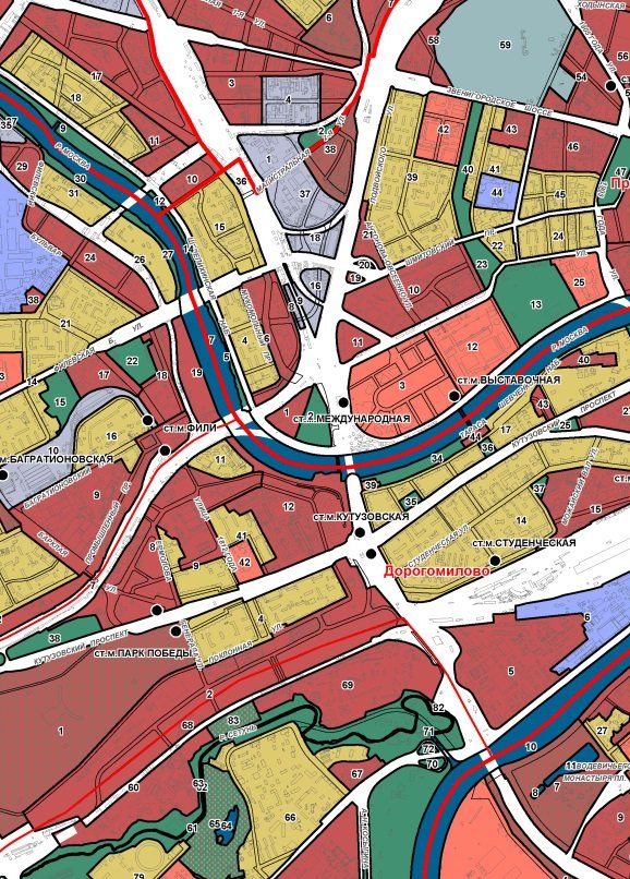
You can also look at individual zones - for example, find areas intended for the placement of capital construction projects for various purposes. They will look like this:
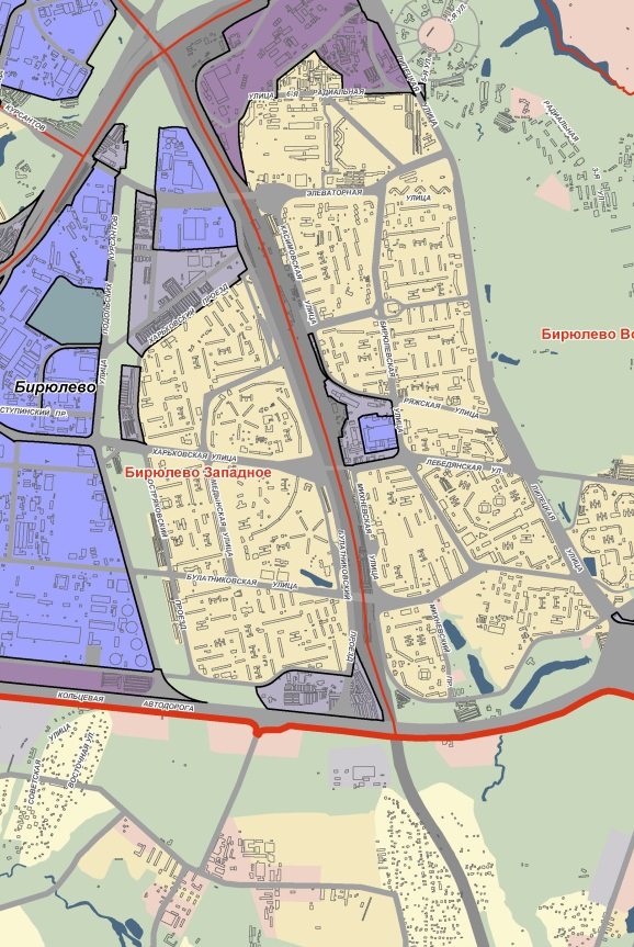
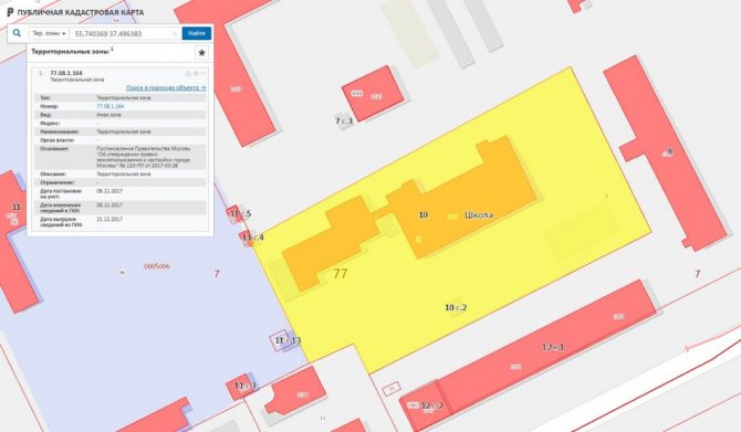
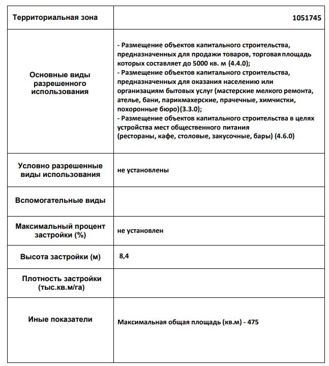
The third way is to open the land use and development rules (PLZ) of the city of Moscow. The document describes in detail all territorial zones, and you can view them both for a separate area on the map, and find a detailed description in the documents. It will look like this:
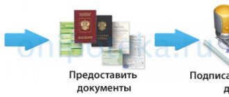
Finally, the fourth way is to contact the MFC or Rosreestr directly and order a cadastral extract. It will indicate the territorial zone, as well as all permissible types of permitted use of the land.
What is zoning of a land plot?
Territorial zones are land areas united by the possibility of developing specific types of objects.
On the master plan, such zones are distinguished by color and also by letter designation. Territorial zones detail functional zones, that is, they establish urban planning regulations in individual territories, giving each land plot a legal regime. Functional zones of the legal regime of land plots do not establish, but influence it indirectly through territorial zones established in accordance with the Land Use and Development Rules (LRU).
How to find out the category of land and type of permitted use
If the purpose of the land plot corresponds to the list of objects that can be located in this zone, then the owner of the plot can change the type of permitted use free of charge.
What information can be obtained by knowing the territorial zone?
Each territorial zone in Moscow has its own urban planning regulations. They stipulate what types of permitted use are available to citizens for land and capital construction projects, what are the maximum permissible parameters for the construction and reconstruction of objects. It is important to note that within one zone there may be subzones with the same VRI of plots and structures, but different maximum plot sizes and maximum parameters of capital construction objects.
Thus, knowing the territorial zone, you will receive information about:
- The main types of permitted land use. They are very important for the owner of the site, as they determine the possibilities of use. Moreover: the owner has the right to independently choose any of the main VRIs, so their list can determine the attractiveness of the land for an investor and the possibility of optimal use for the owner.
- The maximum permissible area of one plot.
- Maximum building percentage.
- Building height.
- Building density.
If you do not want to figure out on your own which territorial zone the site belongs to and what types of permitted land use or maximum parameters apply for a capital construction project, contact Smart Choice specialists. We provide legal services for businesses in Moscow, and our lawyers will help determine legal uses of real estate and advise on the possibilities of changing the functional purpose of the site.
How to find out in which territorial zone a land plot is located
The seller who offers the plot will not be able to deceive the buyer regarding the type of permitted use of the land. After all, the data is publicly available. Therefore, every citizen, subject to a certain algorithm, will be able to familiarize himself with them.
Info Categories of land in the Russian Federation The legislation of Russia introduced certain types of permitted use of land plots. The division is carried out on the basis of a document providing options for using the plots. Important All territories have a corresponding purpose. Species are one of the constituent categories of land in a country.
The latter include: A specific plot can be categorized by the owner himself. The types are determined by the town planning regulations. At the time of construction, it is important to immediately specify the type.
After all, changing the assignment in the future will be problematic.
Territorial zones of land plots: concept and legislation
According to the Town Planning Code, a territorial zone is a territory for which boundaries are defined, and established town planning regulations apply to it. Each site belongs to one specific territorial zone.
Such zones are allocated on the basis of territorial planning in order to establish urban planning regulations. It is urban planning regulations that determine the various types of permitted use for each territorial zone, as well as construction standards and rules for the reconstruction of capital facilities.
Article 9 of the Town Planning Code contains basic planning goals:
- Determination of territorial planning based on a complex of socio-economic, environmental and other factors.
- Sustainable development of the territory.
- Development of engineering, social and transport infrastructure.
- Taking into account the interests of residents.
Article 85 of the Land Code highlights the main distinctive features of the territorial zone:
- the need to take into account its location and development;
- clear boundaries;
- the possibility of combining several types of permitted use within one zone;
- established urban planning regulations are the basis of the legal regime;
- no possibility of causing damage to capital construction projects.
Documentation regarding the territorial zones of land plots is drawn up in graphic form as a map or plan of the land management facility. Each color on this map corresponds to a specific territorial zone. The map is always supplemented by an explanatory note in the form of a text form, which contains the size, boundaries of objects, as well as other characteristics.
A diagram indicating territorial zones is entered on the public cadastral map. Cadastral engineers are responsible for preparing maps.
What is the territorial zone of a land plot and how to find it out?
The main types are determined in accordance with their purpose:
- Agriculture;
- residential buildings;
- capital construction;
- entrepreneurship;
- rest;
- transport;
- production;
- defense and security, etc.
For each section there are also sub-items. They are defined according to territorial zones. There are conditionally permitted types of use of plots. They are established on the basis of urban planning regulations in relation to territorial zones. Such territories require mandatory consent to establish the species, issued by local authorities.
Types of zones
In the process of urban planning zoning of a territory, specialists can distinguish the following territorial zones:
- residential;
- public and business;
- production;
- engineering and transport infrastructure zones;
- agricultural use;
- recreational purposes;
- zones of specially protected areas;
- special purpose;
- placement of military facilities;
- In municipalities, other types of territorial zones may be allocated, based on the specifics of the area.
Above is a general classification of territorial zones. In turn, within each of them subspecies can be distinguished. Thus, residential zones may include development zones:
- individual residential buildings;
- low-rise buildings;
- mid-rise;
- multi-story.
Also, in residential areas it is allowed not only to build houses for living, but also social, communal and household facilities, healthcare (hospitals and clinics), education (schools, kindergartens, etc.), religious buildings (churches), parking lots, garages . At the same time, it is not allowed to build industrial buildings and structures that negatively affect the environment.
The Town Planning Code of the Russian Federation specifies the main, conditionally permitted and auxiliary types of permitted use of sites and capital facilities. Accessory uses usually complement the primary and conditionally permitted uses of the sites.
The table shows the intended purpose of various land plots, taking into account their territorial zone.
What are territorial zones according to land legislation
On the online cadastral map it is possible to:
- Find out the cadastral number of a land plot by address or location,
- Determine the boundaries of the land plot,
- Find the plot on the map using the cadastral number,
- Find out the cadastral value,
- Land area,
- The exact address of the land plot by cadastral number,
- And other cadastral information (full name of the contractor, cadastral quarter, form of ownership, authorities servicing the property, date of cadastral registration, etc.).
You can find out the owner or possessor of a land plot by cadastral number by contacting the Unified State Register and paying the state fee for providing information; we will talk about this in the next article.