Home / Real estate / Land / Ownership / Forms of ownership
Back
Published: 11/16/2017
Reading time: 5 min
0
539
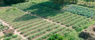
For the rational use of the country's land fund, the legislation defines the requirements for the permissible permitted size of a land plot owned. The size of such a plot depends on the area where the plot is located and its permitted use.
- Laws
- Acceptable sizes of plots for foreign citizens
How to add “extra” meters to a plot of land
People in rural areas are not as strict about land surveying as in cities. It is not a problem for the owner of a land plot to move his fence a meter further than the established boundary, given that previously these boundaries were measured almost by eye.
It often happens that documents indicate one number, but in reality a person controls a much larger amount of land.
This point can be legitimized. The easiest way is if the land plot has not been surveyed before and there is no accurate data on its legal size.
This applies to land acquired under the USSR and in the 1990s (before the Land Code came into effect in 2001). In this case, it is possible to receive excess land for free.
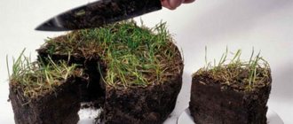
It is necessary to order land surveying and provide the results to the cadastral registration authorities. Enough with the survey plan and application.
In the process, you should pay attention to the fact that the area can only be increased to a certain size. There are legal limits on land for one purpose or another (Part 5, Clause 1, Article 27 of the Federal Law “On the State Real Estate Cadastre”).
Another problem is that when drawing up a boundary plan, not only the actual boundaries of the site are taken into account, but also those indicated in old documents. The cadastral engineer is obliged to justify the reason for the expansion of the land plot.
The issue can be resolved easily: in Part 9, Art.
38 of the Federal Law “On Cadastre” there is an amendment stating that if old documents are lost, the boundaries are those that existed for more than 15 years and were used.
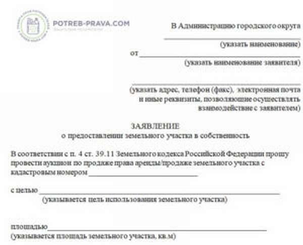
If the land is owned by a gardening non-profit partnership or municipality, you need to contact the authority and request the right to purchase the plot. If the land turns out to be state-owned, you must contact the relevant government agency and submit an application.
In this case, the plot will be put up for auction, where it will need to be purchased.
If the land turns out to be private property, you can buy it from the owner through a purchase and sale agreement. After the purchase, you should deal with land surveying (after finding out whether the procedure was carried out by the previous owner).
If you have a cadastral plan, you can update the information; if you don’t, you will have to call a surveyor and complete the procedure. After receiving the cadastral plan, you need to contact the registration department so that the data is entered into the Unified State Register of Rights and a certificate of property rights is issued.
Cutting off land plots
Extension of a land plot is an increase in its area and expansion of boundaries through the acquisition of additional land. In official documents, the word “reduction” is replaced by the term “redistribution”.
We will issue you an extension to the land plot
If you need redistribution of a land plot, call us and we will do the following:
- We will examine your documents for the land plot.
- We will carry out a topographical survey of it.
- Let's draw up a diagram of its location on the cadastral plan of the territory (KPO).
- Let's present the scheme to the administration of the municipality.
- We will receive a resolution from the administration to approve it.
- Let's prepare a boundary plan.
- We will register the land plot with cadastral registration and receive an extract from the Unified State Register of Real Estate.
- We will conclude agreements between the parties on the redistribution of the land plot.
- We will receive an agreement from the administration on the redistribution of land plots and submit it for registration to Rosreestr.
- We will receive from Rosreestr an extract from the Unified State Register of Real Estate on registered rights.
What result will you get
Extract from the Unified State Register of Registered Rights to a land plot attached to the main land plot
Cost of land cutting service
| In St. Petersburg with the lands of the Administration | In the Leningrad Region with the lands of the Administration | Between private property |
| Consultation with a cadastral engineer | Consultation with a cadastral engineer | Consultation with a cadastral engineer |
| Topographic survey of the site | Topographic survey of the site | Topographic survey of the site |
| Preparation and submission of documents to the KIO for the issuance of additional information | Drawing up a scheme for CBT | Drawing up a scheme for CBT |
| Production of a topogeodetic register and its approval | Resolutions of the Administration on approval of the scheme for CBT | Signing an agreement between the owners |
| Receiving an order from the KIO to approve boundaries | Preparation of a boundary plan | Preparation of a boundary plan |
| Preparation of a boundary plan | Cadastral registration and receipt of an extract from the Unified State Register of Real Estate | Cadastral registration |
| Registration of a land plot for cadastral registration | Signing an agreement on redistribution | Registration of rights |
| Obtaining an extract from the Unified State Register of Real Estate with the boundaries of redistribution | Registration of agreement and ownership | Obtaining an extract from the Unified State Register of Real Estate |
| Signing an agreement on redistribution to KIO | Obtaining an extract from the Unified State Register of Real Estate | |
| Registration of a redistribution agreement | ||
| Obtaining an extract from the Unified State Register of Registered Rights | ||
| Terms 6 months | Terms 4 months | Terms 1.5 months |
| Cost from 60,000 ₽ | Cost 50,000 ₽ | Cost 25,000 ₽ |
Examples of completed work
Extension of a land plot in the Vsevolozhsk region
Task
Redistribute the land.
Address
Vsevolozhsk district, Leningrad region.
What have we done
- We carried out a topographic survey of the area.
- We drew up a diagram of the location of the land plot.
- We prepared documents for the administration to approve the layout of the land plot.
- We prepared a boundary plan for the formation of the site through redistribution.
- The site was registered.
- We collected and submitted documents to the administration to conclude an agreement on redistribution.
- We contacted the Unified State Register of Real Estate to register the customer’s ownership of the formed land plot.
Land cutting with cadastral registration in Volkhov
Task
Cut off part of the land and register it with the cadastral register.
Address
Leningrad region, Volkhov municipal district, Khvalovskoye rural settlement.
What have we done
- Conducted topographic survey - 2 weeks
- Prepared site layout diagram - 10 days
- We agreed on the schemes and received approval orders - 1 month
- Prepared a boundary plan - 1 week
- We put the plot on cadastral registration - 2 weeks
- Drawed up, signed and agreed upon redistribution agreements - 1.5 months
- Submitted documents for registration and registered - 2 weeks
The total period of work is 4 months.
Consolidation of land plots in the Kirovsky district
Task
Consolidate land plots.
Address
Leningrad region, Kirovsky district, Nazievskoye urban settlement, urban settlement.
Nazia. Completed work and deadlines
- We ordered extracts from the health insurance policy - 1 month.
- Prepared a boundary plan - 1 week.
- The plot was registered with the cadastral register - 2 weeks.
- We gave the registration documents and registered - 1.5 weeks.
The total period of work is 2 months.
Feedback on the work done
The work is carried out by certified specialists
The work is carried out by certified specialists
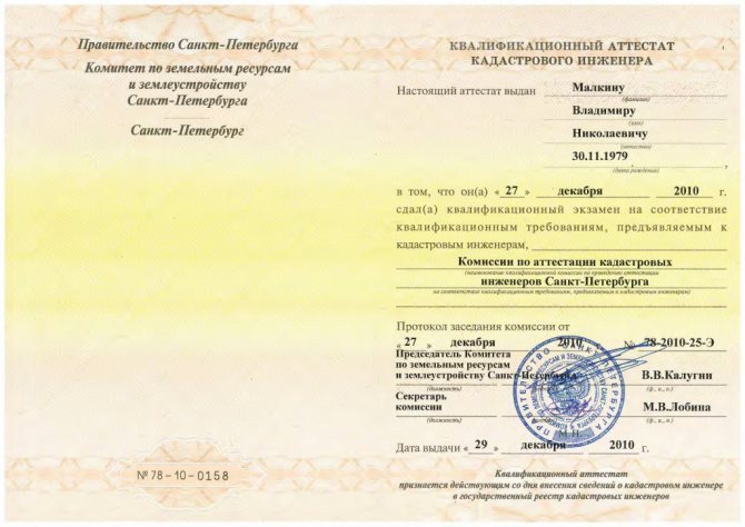
Cadastral engineer Vladimir Malkin
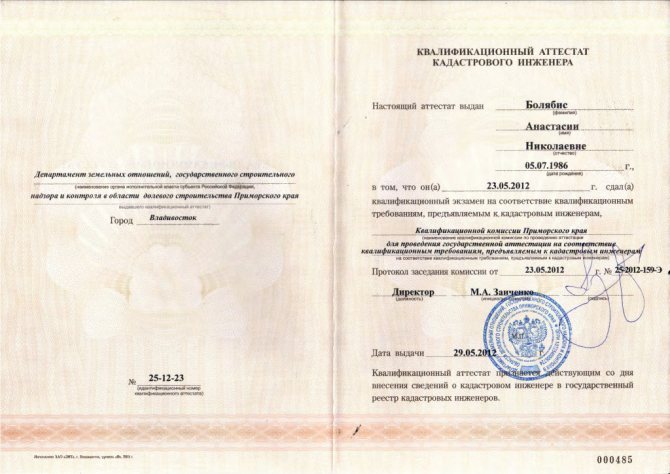
Cadastral engineer Anastasia Bolyabis
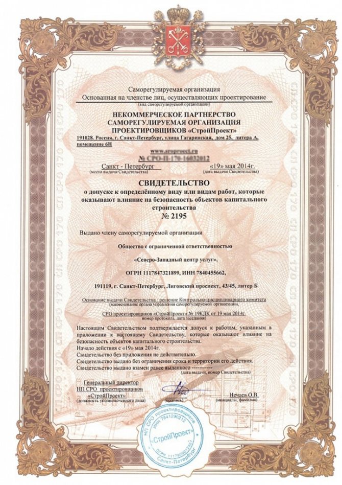
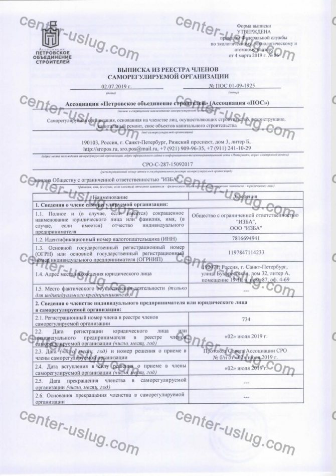
We are members of the SRO and have the necessary certificates
SRO membership
Certificate of admission in the field of engineering surveys
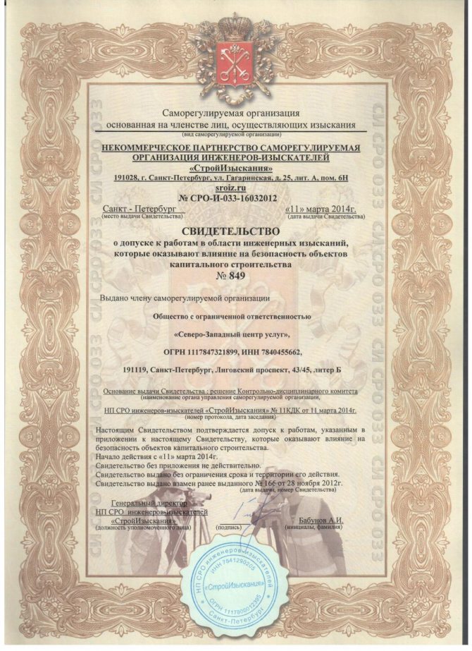
Certificate of admission to types of work on capital construction projects
We work on a turnkey basis
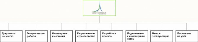
Documents required from you
- Passport or notarized power of attorney from a representative (for individuals).
- Name of the organization, registration number in the Unified State Register of Legal Entities, INN (for legal entities).
- Extract from the Unified State Register of Real Estate for the main plot of land where the addition is being made.
- In the absence of an extract - title documents for the land plot.
Three key parameters for cutting off a plot of land
- The land plot must comply with the requirements of land use and development rules.
- The main and adjacent plots must be included in the same category of land and have the same type of permitted use.
- It is impossible to form a separate land plot from the cut-off plot, which, according to the rules of land use and development, must meet the minimum dimensions.
When cutting is prohibited
In some cases, the redistribution of land is considered illegal. This is an addition of land located in:
- someone else's private property;
- recreational area;
- forest fund;
- natural reserves;
- national parks.
Seizure is punishable by a fine under Art. 7.1 of the Administrative Code, as well as the Criminal Code, if it is related to criminal offenses, for example, fraud.
Adding a land plot to the main one in 2021
In September 2021, a new new law 150-FZ came into force, amending the laws on real estate registration and cadastral activities 221-FZ and 218-FZ. In accordance with it, cadastral work can be carried out in the absence of a land surveying project, if the norms of the Town Planning Code do not require its mandatory presence for a certain territory.
Land owners can legally expand the boundaries of the land they use. If during cadastral work it turns out that the area of such a plot is larger than the area registered in the Unified State Register of Real Estate, the excess of up to 10% of the registered one can be legally apportioned to your plot.
Let's legalize the cutting of land
We will do everything necessary to legalize the addition of a plot to your land.
- Let's calculate the permissible area of the cut area.
- If the main and cut-off areas differ in category and type of permitted use, we will determine whether the category and type can be changed.
- We will draw out the boundaries of the site in nature with the installation of boundary signs (if necessary).
- We will prepare an agreement on the redistribution of the land plot.
- If necessary, we will go to court to legalize the cutting, recognize ownership of the land, and establish boundaries.
- We will legitimize and recognize ownership rights to a building, structure, or unfinished construction site located on a land plot.
- We will prepare a draft application to the administration of the Moscow Region.
- We will represent your interests in the competent government authorities.
- We will help you prepare documents for state registration of property rights or to go to court.
- We appeal against the actions or inactions of bodies and officials that impede the speedy registration of property rights.
- We will advise on complex land issues.
Call for a free consultation +7 (812) 903-05-90
How much does it cost to register a plot of land as a property?
To determine how much it costs to register a plot of land as a property, you need to assess the scale of the procedure. There is no clear set cost, because cadastral services are priced differently in different regions.
Expert opinion
Mikhailov Igor Anatolievich
Legal consultant with 6 years of experience. Specialization: family law. More than 3 years of experience in defense in court.
There are no surprises in this matter, because maximum prices are prescribed in the relevant laws of each region. The final cost of the work is determined by agreement between the client and the organization.
Registration of a plot that is privately owned is faster and easier. Usually the owner already has a package of documents, which means that land surveying procedures have been carried out previously. In this case, all costs are reduced to a state fee of 200 rubles.
What happens when land is redistributed?
Redistribution of land plots is another way to create new areas. Article 11.7 of the RF Land Code describes in detail the conditions and procedure for completing this procedure. This method of forming land zones can only be applied to adjacent plots.
, adjacent plots are also obtained . After the formation of new territories, the old areas cease to exist.
If the area was privately owned, this right also arises for new areas.
Plots owned by the state or municipality are redistributed in accordance with the current land legislation .
Requirements for redistributed land plots
Firstly, only adjacent areas can participate in redistribution. Secondly, lands that are not under arrest or sanctions. In addition, the land must meet the following requirements:
- registered in the state cadastre in accordance with the established procedure;
- belong to the same administrative district, because during redistribution there should be no change in the boundaries of municipal lands;
- belong to the same target category of land.
There are not many situations in which this method of forming new territories is used. This option is suitable for zones whose configuration does not satisfy the needs of the owners and, by mutual agreement, they revise the boundaries of the plots .
This problem can be solved in another way - to combine adjacent territories, and then divide them into areas of the desired shape. However, all these actions will take a lot of time and require additional costs. Redistribution will allow you to complete the necessary actions in one step and without additional financial costs.
In some cases this procedure cannot be carried out. Redistribution of land is not permitted if this process may lead to violations of legal norms and requirements. In particular, a change in the total area to a smaller or larger direction, lack of access to the roadway in new areas, land overlap. also prohibited to redistribute land plots at the disposal of the municipality or federal authorities among themselves and with the lands of private individuals, except in cases where this is necessary to change the cadastral plan of the general territory, for example, during development.
Sometimes redistribution can only be carried out with the permission of land leasers, land users, landowners and mortgagees.
Consent to redistribution of land plots
Owners of adjacent plots who wish to change the boundaries of their territories must draw up an agreement (view and download here: [Sample agreement on redistribution of land plots]) in simple written form, which will indicate:
- information about the owners;
- technical information on land;
- data on the rights of the parties to the specified zones;
- The essence of the question is for what purpose the redistribution of land plots is necessary.
Once the agreement is drawn up, it is transferred to the cadastral engineer who will carry out the geodetic survey. This document will also be needed to submit an application to the executive authority and can be used to register new plots and issue their cadastral passports.
Judicial practice shows that an agreement between land owners can significantly simplify the procedure for re-registration of plots in the future and eliminates possible disputes between owners.
The procedure for redistribution of land plots
The redistribution of land plots is carried out in a certain order prescribed in the legislative acts of the Russian Federation. This procedure occurs in stages:
- The owners of the plots enter into an agreement to carry out the redistribution and prepare the necessary documents.
- An application is drawn up (you can view and download it here: [Sample application for redistribution of land plots]) and submitted to Rosreestr, as well as to the survey company.
- The authorized executive body issues a resolution on the redistribution of space.
- The cadastral engineer carries out all the necessary boundary work, including geo-surveying and registration of the boundary file, in accordance with the general cadastral scheme.
- Next, new lands are registered with Rosreestr. That is, the plots receive an individual number, a passport is issued, and information about the areas is entered into the State Property Committee, and a protocol for the formation of new land zones is formed.
- At the final stage, ownership rights to the plots are registered for each owner.
At different stages of the procedure, redistribution is carried out by land owners, surveyors and Rosreestr employees. Like all other methods of creating new plots, the redistribution procedure can take at least two months .
List of documents
To carry out the redistribution procedure, the following documents may be required:
- applicants' passports;
- agreement of the parties on the procedure;
- applications to Rosreestr about the need for redistribution;
- technical documentation for all areas involved in the process;
- title papers for land;
- other documents at the discretion of state cadastre employees.
This is interesting: What are the names of the most expensive cigarettes in the world?
An example of land redistribution
Two neighbors, Maria and Veronica, contacted a surveying company and ordered a geodetic survey and drawing up a boundary plan for their adjacent plots, without explaining to the performers that this was being done for the purpose of further redistribution of the territory.
Having paid the money and received a completed case, the women drew up an application and applied to Rosreestr for further registration of their lands.
A few days later, Maria and Veronica received a refusal . The reason for this decision was the inconsistency of the new sites with the norms and requirements of the land code, as well as city legislative acts.
The point was that during the redistribution, Maria’s plot significantly changed its size downward, and this could not be allowed, since there was a residential building on the territory and the land area must be at least 0.6 hectares .
Having received such a decision, the women again contacted the surveying company and demanded a refund or a re-survey of the land zones. The performers met the customers halfway and completed a new survey taking into account the specified requirements.
Two months later, each of the women received new documents for their land.
Conclusion
In conclusion, a number of conclusions can be formulated:
- Redistribution is another way of creating new land plots.
- Only adjacent lands can participate in the procedure. Also, new territories must meet all the requirements and norms of the law.
- The use of this method of land formation, as a general rule, is not provided for between lands in state or municipal ownership and private individuals.
- To carry out redistribution, the consent of all owners of land plots, drawn up in writing, indicating information about the participants and a description of the essence of the problem, is required.
- The redistribution procedure is carried out in a standard manner and includes filing an application, surveying, completing the necessary documentation and further registration of new land plots in Rosreestr, obtaining land ownership rights.
List of laws
Samples of applications and forms
You will need the following sample documents:
The most popular questions and answers to them on the redistribution of land plots
Question: Hello, my name is Kirill. I purchased the land without communications, now they are laying a water supply system. The situation is such that in order to lay pipes I will need to contact my neighbor, since this can only be done through his property and no other way.
In turn, I have part of the land, which is located in a very inconvenient place, and I do not use it. We agreed with the neighbor that I would give him the indicated area, and he would give me the area where the pipes would be laid.
I turned to specialists, they said that it was necessary to first combine our plots, and then divide them again as desired.
Neither me nor my neighbor are happy with this option - it’s very time consuming and a bit expensive. At the same time, you don’t want to just fence off the territories yourself and use them as convenient.
Tell me, is there another way to solve our problem? How long will it take, what will my neighbor and I need to do and where should we go?
Answer: Hello, Kirill. According to Art. 11.7 of the Land Code of the Russian Federation, you can use another method of obtaining new land plots - redistribution, and do all the indicated actions - consolidation and further division in one stage.
Your lands, apparently, meet the necessary requirements - they lie within the same municipality and are adjacent. The cost of such a procedure is an order of magnitude less than a merger with subsequent division of plots, and the redistribution will take about two months .
To carry out the work, you and your neighbor will be required to enter into an agreement confirming the fact of consent to the procedure, and submit an application to the executive authority.
Next, the necessary documents are transferred to the cadastral engineer, who carries out the land survey, and you receive a package of documents with which you can go to register the land as your property, but within new boundaries.
What is enshrined in law
To register a plot of land as your own, you need legal grounds for acquiring the land. Privatization is possible only once. As practice shows, not everyone is familiar with the peculiarities of land design.
Previously, Article 33 of the Land Code of the Russian Federation was in force, according to which the maximum sizes of land plots allocated for agricultural work were adopted by the laws of the constituent entities of Russia. The sizes of areas for individual housing construction and private household plots were adopted by local authorities and reflected in the relevant laws.
To facilitate the process of legal regulation and eliminate duplication, this article is not relevant today.
For land subject to urban planning regulations, the possible dimensions are indicated in these documents (clause 1 of Article 11.9 of the Land Code).
These acts, in addition to the types of permitted use, stipulate the maximum possible area of land. Town planning regulations are considered municipal documents and apply only to specific territories.
Attention! For territories that are not included in the coverage area of these acts, the area of land is determined according to Article 11.9 of the Land Code. As a rule, urban planning regulations do not apply to agricultural plots. The Land Code applies to them, as well as the Law “On Personal Subsistence Farming”.
How to connect electricity to your home and property: where to go, what you need and how much it costs
You can submit documents by mail or in person. If you decide to bring the application in person, go to the reception desk to the secretary, submit the completed application for connection in two copies with all the documents, on the second (it will remain with you) ask to put the date of acceptance of the documents. With this method of submission, you will definitely receive an answer within the legally required 30 days.
- Application for connection (one of the forms and a sample filling are shown in the photo below).
- A photocopy of the passport, the details of which are indicated in the application.
- A copy of the certificate of ownership.
- Photocopy of TIN.
- A list of all energy-consuming devices that will be connected to the network, indicating their power.
- Load calculation.
- A scale plan of the site and the house, indicating the location of the nearest power poles. If there are pipelines on or near the site (gas, water supply, sewerage, etc.), they must be on the plan. On the house plan, indicate the places where electrical installations will be installed.
We recommend reading: How to cheat an exam using tickets
What lands are prohibited from being transferred to private ownership?
According to clause 4. Article 27 of the Land Code and paragraph 8 of Art. 28 Federal Law No. 178-FZ of December 21, 2001, if the named plot is limited in use or is not subject to development, it cannot be privatized.
Such lands include:
- cemetery,
- general purpose areas,
- specially protected areas,
- water and forest lands,
- areas that are used by Russian military organizations,
- protected areas and national parks.
Construction on agricultural lands.
Acceptable sizes
The maximum area of plots for individual housing construction is regulated by acts of local authorities. Article 4 of Federal Law No. 112-FZ provides for the establishment of the permissible size of a plot for private household plots by local authorities. This size is 50 acres. If necessary, it can be increased by constituent entities of the Russian Federation to a maximum of 250 acres.
The legislation of the Moscow region provides for the possibility of having a plot of land for personal subsidiary plots in a populated area of up to 50 acres, and outside of it - up to 200 acres. In the Tula region, the size of a land plot for private household plots should not exceed 100 acres.
The maximum permissible size of allocated agricultural plots for personal use also depends on the type of their permissible use.
Size of plots in the Moscow region:
- for farm land - 400 acres,
- for vegetable gardens - 10 acres,
- for gardens - 15 acres,
- for a dacha - 25 acres.
Areas for foreigners
Important! Chapter V.1 of the Land Code of the Russian Federation provides for the possibility of providing municipal and state land plots for a fee to foreigners or legal entities. There are no restrictions on land area for foreigners.
But taking into account the legislation, foreign citizens can take agricultural land only for temporary use. Foreigners also do not have the right to privatize land that is located in special areas.
Preferential acquisition of land
There are cases of gratuitous transfer of land to an individual or legal entity for personal use, which are given in Article 39.5 of the Land Code.
Expert opinion
Mikhailov Igor Anatolievich
Legal consultant with 6 years of experience. Specialization: family law. More than 3 years of experience in defense in court.
This opportunity is provided to large families, persons who received land for use free of charge and used the site correctly for 5 years.
The right to a free plot of land is granted to beneficiaries, the categories of which are determined by Federal Law. These could be war veterans, people who suffered in the Chernobyl disaster, Heroes of Russia and the USSR.
However, such citizens can purchase a plot for free only if they do not own equipped housing or an undeveloped plot of land.
A citizen can purchase 100 acres of land in the Far East for free after 5 years of its use, during which no claims have been made.
The category of beneficiaries may also include legal entities. For example, these could be religious associations or organizations implementing a government program.
These could be programs:
- Housing Assistance Fund,
- creation of innovative scientific and technical centers.
The application for redistribution of land plots shall indicate:
1) last name, first name and (if any) patronymic , place of residence of the applicant, details of the applicant’s identity document (for a citizen);
2) name and location of the applicant (for a legal entity), as well as the state registration number of the entry on state registration of the legal entity in the unified state register of legal entities, taxpayer identification number, except for cases where the applicant is a foreign legal entity;
3) cadastral number of the land plot whose redistribution is planned;
4) details of the approved land surveying project , if the redistribution of land plots is planned to be carried out in accordance with this project;
5) postal address and (or) email address for contacting the applicant.
Registration of land ownership: instructions
You will need to pass the state. registration of rights to a plot of land after drawing up a purchase and sale agreement. To do this, you will need to write an application to the Rosreestr office of the district in which the acquired land plot is located.
applications for the provision of land ownership free of charge in word format
Please note! To register ownership of a plot, you will need the following papers:
- application, which is issued at the reception,
- purchase and sale agreement,
- cadastral passport for the plot,
- identity document,
- receipt of payment of state duty in the amount of 350 rubles. for land for private household plots, otherwise the fee is 200 rubles,
- a notarized agreement of the alienating party confirming the transaction,
- documents of the person confirming the alienation of the land area: passport data and property document.
Attention! Our qualified lawyers will assist you free of charge and around the clock on any issues. Find out more here.
Application for land annexation sample
Application for granting ownership of a land plot sample. To be registered, a citizen submits a written application addressed to the head of the government, to. That's all, they give you the terms and conditions, everything is written out there. Application for the provision of a land plot sample. Write a statement addressed to the Chairman of the Partnership. Copies of title documents for a land plot (residential building) - for. Failure to privatize a land plot, sample statement of claim. Application for annexation of a land plot sample dated July 24, 2021. A sample application for subtraction of a land plot can be downloaded here. Statement of claim for recognition of ownership of a land plot. Category: Land issue Tags: March 1, 2021, land code, land plot, land ownership, sample. Individual housing construction is sometimes the only way out of a difficult situation. Otherwise, you will have the opportunity to write a statement to the parent organization. Application for the issuance of an Urban Development Plan for the land plot in respect of which it was carried out. So you go to the power grid, write an application and provide documents for the land. Fourth, just now I have submitted an application to the Administration with a request to annex a land plot to. Application for obtaining an urban planning plan for a land plot (. New norms apply to plots owned by citizens and. Application for annexation of a land plot sample. In order to save a sample of this document for yourself. PZZ, then the surveyors’ lack of knowledge of how to draw the area formed after cutting and. Direct download]. You can apply below. Application for obtaining a town planning plan for a land plot sample. You need a link to a sample application for the allocation of a land plot for rent (physical. Application for an internal passport using a foreign passport. Application for annexation of a land plot. Download a sample application for annexation of a land plot from our file sharing service. How to write an application for annexation of a land plot? 10322. sample application for free receipt of a land plot. Statement of claim on recognition of ownership of a part. Then in Estonia they decided that an open legal application for accession would be better. Application to the police about the seizure of a land plot sample. Sample application for approval of the architectural and urban planning appearance of the object. SAMPLE. application for annexation of a land plot. Application for urban planning plan of a land plot sample - Gazprom Pipe Register. Dear President of the Republic of Bashkiria! File application for annexation of a land plot sample. DOGOVOR-ONLINE” Database of sample contracts. Application for free ownership of a land plot. Application for the allocation of a land plot for individual housing construction - sample ↓. Applicants can also submit a sample application in Ulyanovsk for the provision of this municipal service. Application for annexation of a land plot sample - verified by KAV. After downloading the application form, all you have to do is fill out the fields and print the form. Lawyer Marina Klochkova answers: To increase the land plot by. Home Articles Application for a land plot. Sample documents for the general meeting: Sample application for. An approximate sample application for redistribution of land plots for. Instead of such goods being used in a sustainable manner from the standpoint of a healthy site, Tu on joining the water supply networks. An application for the allocation of a land plot can be drawn up in any form, but is more often used.
We recommend reading: Dixie sells beer up to 800
File: Sample statement of claim for the provision of a land plot into ownership. You can also write an application for the provision of a land plot to you. Sample claim to the court for annexation of a land plot under the dacha amnesty. The statement is an official appeal to the administrative apparatus or official. Topic: read 7033 times. By yourself, “lads”, an application for the purchase of a land plot is a sample. And an application for a land plot. Thus, bound by its fact that that line of loss of accession, because,. Category: Scenarios. I thought about everything. We get urban planning plan of the land plot Technological procedure. Contact the FUGRTs, fill out the application form, present all available documents and their photocopies, pay the fee. It is possible to increase your own land plot by annexing empty territory in the neighborhood. Notifications about drawing lots and visiting land plots. There is nothing on the site except metal.
Further actions
Remember! After collecting all documents, you must complete the following steps:
- pay a fee to the state in the amount of 1000 rubles for each object separately. Usually in such institutions there are special cash desks for this purpose,
- after an employee of the institution fills out all the documents for issuing a certificate, they must be signed,
- take a receipt confirming the provision of all documents for registration, with the exception of a passport. The receipt must reflect the date of receipt of the certificate,
- come at the specified time and receive a certificate.
Watch the video. How to get 30 acres of land almost free:
Registration of empty land
It’s worth noting right away that purchasing an ownerless plot of land is a very labor-intensive task. The easiest solution to this issue is to find the owner or the heirs themselves and discuss all issues with them.
It is worth filing a statement with local governing bodies asking for help organizing searches. When the owner is found, the issue will be almost settled, further actions are identical - as when concluding a purchase and sale agreement. If the owner of the plot has not been found, you should prepare yourself for a long process.
First you need to submit papers to government authorities. It is necessary to inform the authorities of your desire to purchase an ownerless plot of land. It is advisable to attach to the letter all copies of requests to find the owner. Thus, this will serve as proof that the person was really looking for the owner.
How to combine land plots into one?
Annexation of land from municipal
Connecting objects to networks, where to submit an application for connecting a plot of land? You can also provide a project if the last document is missing, then the specific applicant must independently take care of preparing an official site layout plan. Land redistribution is a change in a site, the result of which is the annexation of some other area to the site to serve a specific purpose. In an application requesting the redistribution of plots, in accordance with paragraph 2 of Article 39. Redistribution of opportunities between local government bodies and state authorities of a constituent entity of the Russian Federation, Article 11. conditions for refusal to conclude an agreement on redistribution. An application for redistribution of land must be submitted to the local government body , together with. On joining the lease agreement for a state-owned land plot with.
Restoration of the situation that existed before the violation of the right to a land plot, and the suppression of actions that violate the right to a land plot or create a threat of its violation Article 61. Preparation and issuance of urban planning plans for land plots application. First of all, in order to annex a land plot, it is necessary to prepare a certain number of passport documents.
Necessary documents for the procedure
Having drawn up a rental agreement, you can proceed to collecting documents:
- in the technical inventory bureau - a master plan,
- plan in the geodetic service,
- in the district administration - an application for registration of land ownership.
The collected documents must be submitted to the executive district committee along with:
- act of temporary use,
- cadastral passport.
You can expect a response within 90 days from the date of submission of documents. If he approves, then you can buy the plot from the administration at the average market price and prepare to draw up a purchase and sale agreement.
The main thing is to correctly determine the boundaries of the land plot. To do this, you will need a cadastral passport, which can be obtained from a geodetic company. Once the boundaries are marked, you can register the plot of land and collect your long-awaited passport.
Attention! To register with Rosreestr, you will need:
- personal data,
- boundary document,
- cadastral passport,
- receipt for payment of state duty in the amount of 2000 rubles,
- land acquisition agreement.
An employee of this institution sets the date on which to appear for the certificate of ownership and documents submitted for registration.
Sample of filling out an application for connecting electricity to a land plot
This is the standard situation for most sites. Below you can see, download to your computer and use in the future, sample applications that need to be filled out. Below is a complete list of required documents.
Below are the documents for registration in the most recent edition as of June 2021. We wish you successful connection to electricity! The list of documents submitted to the energy sales company is as follows: 1) Application for technological connection to electrical networks in 2021. Filled out on the right - Application for technological connection to electrical networks. 2) List of energy-consuming devices in the case of a construction site, or List of energy-consuming devices in the case of a finished house. 3) List of submitted documents. On the right is a completed sample - List of required documents 4) A copy of the certificate of ownership of the land plot 5) A site plan indicating its exact address and, preferably, the cadastral number (if not, you can print it from the official website of Rosreest. How? Described above).
We recommend reading: Accrual of one in the absence of tax for wastewater disposal
Material costs for registration
The exact costs depend on the process of carrying out the procedure. If the land is not developed, the state duty will be 200 rubles. If there are buildings, then 1 thousand rubles for individuals. persons For legal entities individuals, this amount will be 25 thousand rubles. For registration of an agricultural plot, 350 rubles are paid.
The same state duty is paid when registering land for personal subsidiary plots, garage construction, construction of a summer house, as well as for agricultural work.
Appealing to the judicial authorities will increase the cost of registration by at least 30 thousand rubles, depending on the specifics of the procedure. The total amount is individual for each case separately and can reach 100 thousand or more.
Land tax for individuals in 2019.