In order to carry out land surveying, it is necessary to collect a package of documents. When contacting a cadastral engineer, he informs you what documents are needed to survey a land (dacha, garden) plot, as well as the algorithm of actions, how the registration procedure itself goes, and what documents must be handed over to Rosreestr after surveying. You can find out who exactly is engaged in land surveying in your region in the catalog of performers providing cadastral services, and a free online cadastral work calculator, created for the convenience of our readers, will help you find out what prices are set for this type of work.
What document is issued after land surveying?
Upon completion of the compilation of the cadastral plan and the delimitation procedure, the surveyor hands over to the owner of the plot a boundary plan, certified by the signature of the compiler and the seal of the geodetic company. The owner of the plot has the right to request a plan in electronic form from the cadastral engineer.
Attention! The boundary plan contains information about the boundaries drawn up based on the survey results. This document is considered:
- Evidence in court in case of claims by neighbors,
- The basis for registering a plot of land with the cadastral register if the owner has not done so earlier.
What to do after land surveying and what the survey document looks like
If a citizen needs to register a plot of land in the cadastre, then he needs a boundary plan to submit to the government agency. Therefore, after the land survey, the applicant submits an application and all necessary documents to the Rosreestr branch at the location of the land, so that specialists can register it.
Therefore, before the appointed time, all landowners need to carry out this procedure, although previously the law was not obligatory to do this. However, the Russian authorities are thinking about expanding the tax base through land properties and reducing the number of unregistered plots of land.
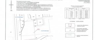
What does a boundary plan look like?
A boundary plan is a technical document that contains geodetic data of a plot of land. The boundary plan consists of two parts: text and graphic.
The text part contains the following information:
land survey plan for free in word format
- Data on cadastral works,
- Initial data of the site,
- Information about the measurements taken,
- Customer data,
- Cadastral engineer data,
- Information about parts of the land plot,
- The conclusion of the cadastral engineer who carried out the measurements
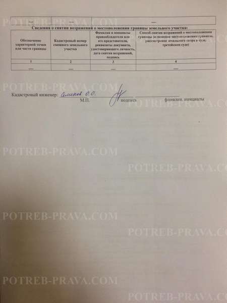
- Boundary approval act.
The graphic part consists of a diagram of the land plot indicating the boundaries, dimensions, and objects.
What are the consequences of not having a site surveyed?
Documents for land surveying
applications for land surveying free of charge in word format
It is worth noting that the set of documents for demarcating plots owned by individuals and legal entities is different.
For individuals, demarcation is made on the basis of the following documents:
- Passport or notarized power of attorney for the representative of the owner of the plot,
- Documents confirming the right of ownership of the land plot (if the plot was purchased - a purchase and sale agreement, if received as a gift - the original deed of gift, if inherited - a certificate of inheritance, if received for use - a deed for the right to use the land plot from the local administration),
- If registration has not been carried out, you must provide an extract from the Unified State Register,
- Cadastral passport containing general information about the land plot, information about its boundaries and area,
- Certificates from the BTI about the absence of buildings,
- If there are buildings on the site, then a certificate containing information about the objects will be required.
- Cadastral plan of the territory, which is issued by Rosreestr based on an application from the owner.
The above documents are attached to the application for boundary work. However, this list is not final. Additional documents may be required. This should be clarified with Rosreestr.
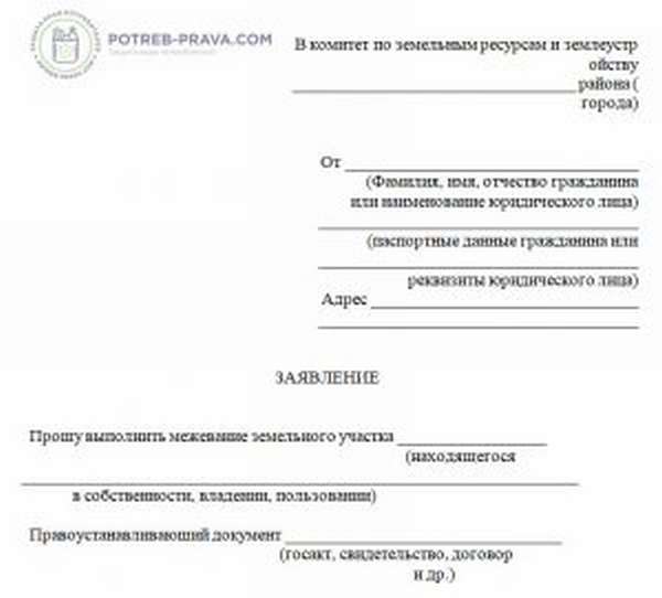
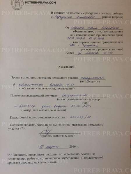
ATTENTION! Look at the completed sample application for land surveying:
Attention! Our qualified lawyers will assist you free of charge and around the clock on any issues. Find out more here.
Documents that may be needed in the process of registering a land survey:
- Title documents (purchase and sale agreement, certificate of inheritance, resolution on the provision of land, court decision, etc.)
- Cadastral passport of the plot or extract from the Unified State Register of Real Estate. (You can order at the local Rosreestr office or at the MFC)
- Cadastral plan of the territory
- Cadastral passport of buildings or USRN extract
If the site is located in SNT, you may need:
- Copy of a fragment of the general plan
- Certificate of state registration of this SNT.
Based on the information provided, the cadastral engineer prepares a boundary plan. It should be remembered that land surveying is not only about working with documents, but also going to the area, so it is better to order land surveying from SNT in garden and dacha plots in the summer, so that you can safely drive up to the site.
What to do after the procedure

act of approving the location of the boundaries of the land plot free of charge in word format
Based on the results of the land surveying procedure, information must be transferred to the Unified State Register of Real Estate.
The following must be attached to the boundary plan:
- Passport of the owner of the plot or a notarized power of attorney of the legal representative,
- Document of ownership of this plot (certificate of ownership or extract from the Unified State Register of Real Estate),
- The document that served as the basis for obtaining ownership of the plot (purchase and sale agreement, gift agreement, will, deed of transfer for use, etc.),
- Cadastral plan of the original site (if one was drawn up),
- Boundary approval act (if required).
An application for entering data into the Unified State Register is drawn up in Rosreestr with the above documents attached.
A complete package of documents can be sent by mail or submitted during a personal visit. If documents are sent by mail, they will require prior certification. Documents should be sent by a valuable letter with notification and a list of attachments.
When submitting in person, you can contact the Rosreestr branch or the MFC, where you can find application samples. The application can be completed either upon submission on site or in advance at home. You must have copies of all necessary documents with you. Copies are submitted for review, and the originals remain in the hands of the owner of the site.
Information about land surveying can also be provided online, on the website of Rosreestr or State Services.
Classifier of types of permitted use of land plots.
How to challenge the land surveying if there are no documents, read here.
How to buy a plot in the DNP, read the link: https://novocom.org/nedvizhimoe-imushhestvo/zemlya/stoit-li-pokupat-uchastok-v-dnp-i-kak-eto-sdelat.html
Attention! On the Rosreestr website information is provided as follows:
- In the section of electronic services and services, select “State registration of rights”,
- In the list that opens, select “Actions with entries in the register of rights to real estate objects of the Unified State Register of Real Estate”,
- Select “Making changes to a record” and click “go to request details”
- Fill out the application form,
- We attach the documents electronically and send them.
Within 18 days from the date of submission of the complete set of documents, an extract from the Unified State Register with the amendments is drawn up or a refusal is sent. The answer is provided at the place of request (to the Rosreestr branch) or by mail to the sender.
If you submit an application online, you can immediately indicate the desired method of receipt - by email.
ATTENTION! Look at the completed sample act of approving the location of the boundaries of the land plot:
Watch the video. Stages of land surveying. Documents for land surveying:
What to do after receiving the plan
What needs to be done next after completing the land surveying procedure and receiving the final documents?
After the boundary plan is received, the owner can submit an application for registration and draw up a document confirming his rights as the owner.
Submission of documents to Rosreestr
In order for the site, the boundaries of which have been established, to be registered, it will be necessary to make an application to Rosreestr - the body authorized to enter and control the database of such data.
A certain period has been established during which you can register the plot free of charge, without paying a state fee - it is 10 days from the date the owner of the plot receives the boundary plan .
Those persons who apply after this period may also have the opportunity to register the site, but do not forget that the structure and requirements for boundary plans may change, and therefore after some time the document may no longer be valid.
Registration of property rights and amount of state duty
To register property rights, the owner of the plot must personally contact the Rosreestr authority, send documentation by registered mail, or submit an application by filling out a special form on the website.
The procedure for registering ownership will consist of the following steps :

- Preparation of documents and collection of the package required for submission to Rosreestr;
- Transfer of funds as state duty. At the moment, its value is standard and amounts to 300 rubles ;
- Submission of the prepared documentation package;
- Review by specialists and issuance of a certificate of registration of property rights.
Deadlines for making changes
The procedure for obtaining a document has a limited time frame for its receipt. After completing the required procedures, information about the site is entered into the Unified State Register within ten working days.
, no more than 10 days should pass from the moment the documentation is submitted until the data is entered . This period may increase due to the fact that the applicant does not provide a complete package of documentation or some of the data submitted by him is unreliable or questionable.
What can you do next with the memory?
If the land surveying procedure is completed, the owner has the right to perform any actions with the site - sell, donate, register ownership. Also, upon completion of the land surveying procedure, the owner has the right to begin registration of buildings on the site. A ready-made boundary plan ensures that buildings will not end up on the territory of a neighboring plot.
Based on the results of land surveying, the cadastral engineer will prepare a land survey plan.
Such a document is drawn up both in paper form and on electronic media. The boundary plan contains information about the site and changes made to the plan. The changes made must be recorded in the Unified State Register. Without making changes, it is prohibited to carry out any actions with the site. A boundary plan is also required when registering real estate on a site.
Consequences of lack of land surveying.
How land boundaries are surveyed - documents, terms, cost
Also, when setting boundaries, the cadastral engineer coordinates land surveying with the owners of neighboring plots. It is necessary to coordinate land surveying with the owners of only those plots with which → 1) there are common boundaries → 2) the neighboring plot has boundaries established in the cadastre → 3) the neighbors have a title document for the plot - clauses 1 and 3 of Art. 39 of the Law on Cadastral Activities.
If the boundaries of the site are determined, then its plan is available in an extract from the Unified State Register or in the cadastral passport. Cadastral passports have not been issued since 2021; they have just been replaced with extracts from the Unified State Register of Real Estate. If the site is being formed for the first time, then a diagram of the location of the site on the cadastral plan of the territory (CZRU) will be required.