Home / Real estate / Land / Cadastral registration / Cadastral number
Back
Published: 06/25/2017
Reading time: 5 min
0
678
Documented cadastral registration in Rosreestr is ensured through nomenclature numbers assigned to each property upon its registration. These numbers are used to perform registration actions and keep records of transactions carried out with the object.
The cadastral number of a land plot is a unique code that allows you to obtain the most detailed information about the property.
- What does the cadastral number of a land plot consist of?
- Decoding the cadastral number
What it is
When completing transactions with real estate, its owners often have the question of what exactly a cadastral or individual number is by legal designation. According to the law, during cadastral and technical registration, each object belonging to the category of real estate is assigned an individual number, which is considered to be a cadastral number. The personal code is entered into the register and is confirmation of the right to property. Entering a digital or alphanumeric code into the cadastre is necessary to identify the object. Using the number code, you can determine the exact location of the site.
How to decipher the site number
When deciphering a digital record entered into the state cadastre, the groups of numbers present in it are considered. The total numerical value is distributed into 4 groups, often separated by signs. Each category of numbers carries its own information load. In this case, the rule of absolute uniqueness of the code is observed. The number assigned to the property is deciphered as follows:
- the first digits determine the regional affiliation of the object;
- the next digital group indicates the territorial district, which is the location of the object;
- the third block gives information about the quarter;
- the final fourth digital combination stores information about the object itself, this is the personal number of the site.
In order to correctly decipher the information hidden in the individual code, you need to know which territorial units are designated by different digital combinations. An electronic map can help with this.
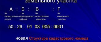
Structure of the cadastral number of a land plot
All numbered designations of objects must be subject to the general rule. According to the established structural format, what the numeric or alphanumeric inventory combination looks like is important. The first two digits indicate the cadastral district, the next two indicate the cadastral district, the four- or six-digit combination that follows indicates the quarterly location of the site. The last four digits contain information about the object itself. In total, an individual number can have from 10 to 16 digits. The standard option is 13 digits.
Decoding
The first two digits of the number, as mentioned above, coincide with the code that determines the region of the country. Such a solution allows you not to get confused about the territorial relation of a specific land plot, immediately attributing it to a certain part of Russia.
The first numerical value, therefore, never changes, since the position of the land plot cannot be changed by moving it from one part of the Russian Federation to another. Based on this, we can judge why the remaining digital parts of the code change.
For example, the administrative division of the city changed, new districts appeared or several old ones were merged, existing internal boundaries shifted. For each of the mentioned situations, you have to change one numerical value, which can consist of either two digits or more.
The second pair of numbers indicates the regional ratio of the land plot. If we are talking about the internal administrative division of the city into districts, this numerical value is different, since two different areas located in two parts of the city do not belong to the same group territorially.
The third group of number values denotes the so-called cadastral zone. It is divided into three categories:
- zone;
- array;
- quarter.
The third group is divided into paired values. If the number increases, then the new number is added to the last pair of the group. Eg:
- 46: 56: 03 07 11: 008;
- 46: 56: 03 07 111: 008.
The fourth number group indicates the individual registration number of the property. The meaning may change depending on its composition. There are three groups:
- land plot without buildings;
- ZU with erected buildings for various purposes;
- the number value of the residential premises (apartment) located in the building.
It should be noted that large cities that experience overpopulation add one digital value to the last group when the need arises.
Assignment of cadastral number:
- The number serves as a unique identifier, which allows you to systematize the available Rosreestr information according to established categories.
- The number allows the property owner and other interested parties to find out all available information about the site, which includes the postal and cadastral address, the area of the land plot and its borders with adjacent land, the established technical characteristics of the land plot, the value of the taxable object (specific and total).
- Admission to various financial transactions with land (sale, lease, purchase, inheritance, etc.)
Example of a cadastral number
An example of what such a number looks like will help you more accurately understand how to correctly decipher it. Symbols of territorial units are transmitted by digital code.
Examples:
| 68:20:2101007:44 | Tambov Region | Tambov district | Streltsy village | St. South, house number |
| 47:23:1203001:810 | Leningrad region | Gatchina district | Gatchina | Coordinates of the site in the register - street, house number with fraction |
You can find out what the digital combination means in online resources. Typically, the first block of the cadastral cipher is equivalent to the number combinations of vehicles in the region. The third block of the cadastral code contains the largest amount of information. It contains the coordinates of the zone, array and quarter.
What is a building cadastral number, what does it mean and what does it consist of?
- legal affiliation (private person, state, municipality);
- information about the current owner and former owners;
- the serial number assigned upon registration of the object;
- current property boundaries and structure;
- existing encumbrances (legal and financial).
The first three indicators are universal and indicate the address of the property - region, district and quarter. Street names and house numbers are data that is not publicly accessible. The last digit is a serial number, which will be individual for each individual object.
May 09, 2021 polrostov 168
Share this post
- Related Posts
- Bailiffs are driving you into debt, you can get out
- Act Upon Detention During Attempted Theft
- Hotline telephone number of Today NTV Program
- Are Witnesses Often Summoned to Court?
Obtaining information via the Internet
You can find out detailed information about the site using online sources. If you have a cadastral number, this is not difficult to do. A schematic representation of any registered plot can be found on a special cadastral map. The electronic version of the state register is available around the clock and contains complete information about all real estate objects that have an individual state registration code. There is no charge for submitting a site plan electronically.
Important! The disadvantage of this method of obtaining information about the desired object is possible errors in the information due to the provision of outdated information.
A more reliable option for cadastral research is to go to the Rosreestr website. After submitting an official application, the application will be reviewed within 5–10 days.
The sequence of actions when submitting a request to Rosreestr is as follows:
- Log in to the official website of the company.
- In the Electronic Services category, find the Go to Sections button.
- Next, find Help information in the services.
- Fill out the feedback form, indicating the exact postal address of the object.
- Next, you need to type Create a request.
In response to the request, information on the site will be provided. An extract can be obtained by applying online and by visiting territorial departments. To obtain an extract on the Rosreestr website you will need to do the following:
- Determine personal status in a special category - individual or legal entity.
- In the Electronic Services section, select Receiving data from the Unified State Register of Real Estate with the ability to draw up a cadastral plan.
- Enter the required data into the form.
- Determine the option for receiving an extract.
- Provide an email address to send documentation electronically.
- At the final stage, you need to make sure that all data is entered correctly.
Decoding, obtaining additional information
- the first two digits are a federal subject;
- the second two are the county in which registration is carried out.
We suggest you read: Responsibility for non-payment of a loan
Sample of the old number - 47-47-03/006/2002/315:
- 03 – registration department code;
- 006 – account book;
- 2002 – the year in which the object was registered;
- 315 – entry in the registration book.
All this numbering is not subject to electronic accounting used throughout the country.
What do the numbers mean? The first two characters are the number of the subject of the Russian Federation, the second are the registration district. Here is an example of the “old” designation: 32-32-03/004/2004-216. After the second hyphen, the combination 01/002/2005 hides the number of the book of registration and accounting of incoming securities, where:
- 03 – code of the Federal Reserve Service department performing the registration of rights;
- 004 – number of the accounting book in order;
- 2004 – the year in which the real estate was registered;
- 216 – the serial order of entries in the registration ledger.
This numbering is quite understandable and logical, but is not subject to electronic recording, which is available throughout the country.
What can you find out from the old registry cipher?
As you can see in the example, a specialist can easily read the information encrypted in the combination.
Using the books in which records of registered apartments, houses, and rooms were kept, it is possible to check what kind of property we are talking about, that is, to identify it.
The first two groups of signs contain a link to the location of the property, the middle group will tell you in what year the entry was made in the registration book under a certain number, where information is entered in order under the digital combination corresponding to the last characters.
The outdated cadastral number represents numeric characters that are not separated by hyphens or bars, unlike the new ones.
Each character has the following meaning:
- The first two numeric characters indicate the code of the region in which the object is located;
- The next two numbers indicate the county in which the information was entered into the registry;
- The next two digits indicate the code of the authority that entered the information into the register;
- The three numbers following them indicate the number of the book in which the records were kept;
- The next 4 digits are the year in which the entry was made;
- The last three digits of the entry are information about the serial number.
Other ways to find out the cadastral number of a property
In addition to obtaining information from Internet sources about an individual number in the cadastre, you can use other available methods to resolve this issue. The most acceptable option is to contact the cadastral chamber, which is located in the city or district administration at the place of registration of the site. This option eliminates the possibility of error, since all information is carefully checked.
To apply, you only need a passport. You will also need to indicate the exact address of the facility. Based on the information provided, an employee of the administrative unit will search for information using the available coordinates. Contacting an official institution allows you to obtain the necessary document based on reliable information.
Private companies also provide information about sites. This type of service is provided on a paid basis. The cost may vary and range from 600 to 2000 rubles. The advantage of this method of obtaining information about a land plot is the possibility of providing express services. Specialized companies provide the following information:
- site plan;
- location of permanent and non-permanent buildings;
- exact cadastral code;
- number of storeys of buildings;
- date of registration of the object with state registration;
- area parameters;
- property type.
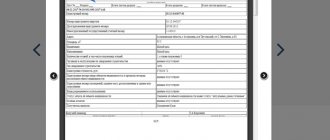
Some information can be obtained independently using the available data in the cadastral passport. Typically, column No. 1 contains information about the registration number. Column No. 11 establishes the cadastral value of the property. For greater reliability, when obtaining information independently, you should use at least two sources - the object’s passport and an online map.
Cadastral number: formation, structure and decoding
Below we will talk about how the cadastral number is formed and how it is deciphered, but first we will have to introduce several concepts with which it is directly related. This must be done so that the reader understands what the author means when using this or that concept.
You may like => According to what laws can a Chernobyl Liquidator of the Chernobyl Accident Get an Apartment in 2021
That is, the number contains complete information about the location of the site, in which subject of the Federation, in which district, municipality it is located and registered. Combinations of numbers in a number are separated from each other by a colon. In the example you will see what it consists of.
Despite the identical composition of the information, receiving free information about the property identification code will not allow citizens to use it to carry out legally significant actions. Information provided free of charge will make it possible to establish certain facts about the object of interest (its location, area, etc.), including violations committed when registering it with the departments of Rosreestr.
Searching for the specified indicator allows you not only to familiarize yourself with information about the selected object, but also to save the information of interest in various types of files, note comments in the technical description of this type of property in the notes, or send a message about a technical error to the accounting information.
- AA – cadastral district. The territory of Russia is divided into 91 districts, which are assigned two-digit numbers. The first block contains information about the region or area where this site is located.
- ВВ – cadastral region. Their number differs in each district, and they also have two-digit designations.
- SSMMTT – cadastral quarter. These numbers indicate small settlements, city districts, etc. Depending on the area of the district, the block consists of 6 or 7 characters.
- KK – land allotment number. It is assigned by Rosreestr employees when registering an object. Depending on the number of plots located in the territory of the block, it contains one or more numbers.
One can talk for hours about the meaning of such a concept as a number in the cadastre. Certainly, if you are far from this issue, you will not be able to appreciate its full importance. Thus, without such a number it is almost impossible to register ownership of a specific property.
Where can I get a cadastral number for an apartment? You can check this number at the apartment address through the online system. The most convenient way is to search in the Rosreestr database - the Federal Service for State Registration of Cadastre and Cartography.
- View in the cadastral passport. The fastest and easiest way, but the document may contain errors and the code itself may change.
- Through the Rosreestr website. You just need to fill out the form on the page and submit your request. The answer will be sent by email.
Useful features, what to do if there is no number
A personal number is issued during the privatization of a plot if there is a right to the property and the boundaries have been agreed upon. Due to the fact that the presence of a number in the cadastre is not mandatory, a situation may arise when the owner of the object does not have a code. Such an omission may complicate the following real estate transactions:
- conducting property disputes;
- carrying out a purchase and sale transaction;
- legal proceedings regarding the legality of the right of ownership of property by the current owner;
- the need to formalize a deed of gift;
- drawing up a will for this object;
- registration of a mortgage secured by the plot;
- object insurance.