Cadastral value is the equivalent of the market value of a property, obtained through an assessment taking into account its intended purpose and location.
Required for calculating land tax and setting prices for various real estate transactions.
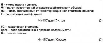
Information about the cadastral value of each property is entered into the State Real Estate Cadastre.
The cadastral value can be determined by mass valuation or by calculating the individual value of an individual object.
The assessment is carried out by independent experts by decision of local authorities, who are required to select an appraiser and sign an agreement with him.
Description of the state procedure
A cadastral valuation is a list of technical and administrative actions to establish the cadastral value of objects on a specific date.
It is carried out using special techniques, taking into account information about transactions on the market, the level of rent, and the profitability of plots.
The appraiser studies and forecasts rent generation depending on the location and quality of the land . When calculating, it is necessary to take into account the improvements made, the level of transport and social infrastructure, and amenities.
The expert has the right to use information from various cadastres, housing and construction standards: coefficients developed by the BTI, authorities, land and architectural committees.
The cadastral value of land plots is determined depending on the territorial location, area, category and permitted use of the site.
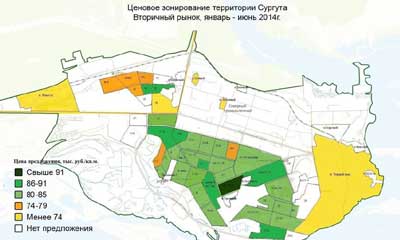
Within the city limits, this is the simultaneous determination of the cost of objects en masse, which consists of :
- collecting information;
- dividing the city into zones;
- calculation of the cost of assessment;
- price zoning of the city;
- recording the assessment results.
The result is the establishment of the cost of a plot according to the assessment zone or the size of a typical plot, similar to the price of similar plots on the real estate market.
Officially establishing the cost and recording it in the Register allows you to solve several problems at the same time :
- The state is creating a unified system of taxation of land holdings of the state and private individuals, which allows optimizing the system of calculation and accounting of taxes, filling the budget and forecasting future volumes of tax revenues.
- Regional authorities have the opportunity to rationally use and manage plots of land, distribute real estate, and issue construction permits.
- Individual property owners have the opportunity to count on fair tax assessments, conduct real estate transactions, and make investments.
The cadastral value usually tends to the market level ; when it is carried out, almost all factors that are important in market valuation are taken into account, but it cannot exceed the market value.
Stages of land assessment
The process may differ depending on the type of assessment, but basically the algorithm is the same:
- You decide what kind of assessment you need. Just an assessment for sale - you can contact an expert or see the section on self-assessment of a land plot. In other cases, we recommend contacting the manager and telling about the specific situation. There are subtleties, ignorance of which can cause you to lose money. For example, an assessment for the court costs some money, and an assessment for the tax office costs another. Why pay more? Call our managers – telephone consultation is free.
- Meet with the appraiser at the property. Submit the necessary documents, sign the agreement. Please note that all professional experts work in accordance with the law and enter into an agreement. Be careful when trying to save money and order an assessment from an unknown private party.
- After the contract is concluded, the appraiser will take photographs and inspect the land.
The remaining stages take place without your participation - the specialist analyzes the market, looks for similar offers, structures and calculates similar transactions from the history of the microdistrict. All this is necessary to establish the current value of the land.
The market value assessment report will be ready within 2-5 days. If you need it urgently, it will be more expensive.
The report will contain all the information about the expert himself, about the customer and about the object that was examined. Attached will be photographs that the expert took on the land plot. If the order was to obtain a mortgage loan, then the conclusion will contain two amounts - market and liquidation values.
You can order not only a market value study, but also other types of assessments. For example, a report on the assessment of cadastral value will also be ready in 3-5 days.
Please note that the assessment of a land plot, the assessment of a house and the assessment of a house with a land plot are three different assessments. Please take this into account when ordering a cost assessment. Contact our managers, we will tell you how to correctly formulate a task for an expert.
Normative base
The conditions and regulations for conducting a cadastral valuation are regulated by the provisions of the Land Code of the Russian Federation and the following federal laws :
- “On state cadastral valuation” dated 07/03/2016 N 237-FZ
- “On cadastral activities” dated July 24, 2007 N 221-FZ
- “On state registration of real estate” dated July 13, 2015 N 218-FZ
- “On valuation activities in the Russian Federation” dated July 29, 1998 N 135-FZ
When assessing, you must rely on the following orders of the Ministry of Economic Development of the Russian Federation :
- Order of the Ministry of Economic Development of the Russian Federation dated 02/15/2007 N 39 (as amended on 01/11/2011) “On approval of the Methodological Guidelines for the State Cadastral Valuation of Land in Settlements”
- Order of the Ministry of Economic Development of the Russian Federation dated August 12, 2006 N 222 (as amended on November 17, 2011) “On approval of the Guidelines for determining the cadastral value of newly formed land plots and existing land plots in cases of changing the category of land, the type of permitted use or clarifying the area of the land plot”
- Order of the Ministry of Economic Development of Russia dated 06/07/2016 N 358 (as amended on 05/12/2017) “On approval of methodological instructions on state cadastral valuation”
- Order of the Ministry of Economic Development of Russia dated December 8, 2015 N 921 (as amended on November 23, 2016) “On approval of the form and composition of land survey plan information, requirements for its preparation”
- Order of the Ministry of Economic Development of the Russian Federation dated September 20, 2010 N 445 “On approval of the Guidelines for the state cadastral valuation of agricultural land”
Decrees of the Government of the Russian Federation applied during the assessment:
- Decree of the Government of the Russian Federation dated 04/08/2000 N 316 (as amended on 06/30/2010) “On approval of the Rules for conducting state cadastral valuation of land”
- Decree of the Government of the Russian Federation of August 25, 1999 N 945 “On the state cadastral valuation of land”
It is necessary to adhere to the legally approved Federal assessment standards :
- “General concepts of assessment, approaches and requirements for assessment (FSO N 1)”
- “Purpose of valuation and types of value (FSO N 2)”
- “Requirements for an assessment report (FSO N 3)”
- “Determination of cadastral value (FSO N 4)”
Economic assessment
The economic assessment of land plots reflects their economic value and potential effect from use.
Typically, economic assessment refers to market assessment.
Land value assessment is a procedure for determining the value of land in monetary terms, taking into account the potential and actual income of the site, which is determined at a certain point in time, taking into account the functioning of a specific market segment.
In other words, the market valuation allows you to understand at what price a given plot can be sold in a free market at a given time.
The assessment process takes into account both specific factors in the pricing of land plots and macroeconomic/microeconomic conditions.
The economic assessment of land plots usually takes into account the location of the land, its intended purpose, the physical parameters of the land, the supply/demand ratio, the nature of supply/level of competition in the real estate market, the expected amount of income from the exploitation of the land, and the payback period. It is important to understand that market valuation is always very dynamic and when the intended purpose of the site changes, it also changes.
Economic valuation is often understood as the market value of the leasehold right. It depends on the legal status of the tenant, the duration of the contract, the presence of encumbrances and easements, and the rights of other persons to the property. This cost is also determined by the size, duration and likelihood of income from rental property with the most efficient use of the site.
One of the types of economic assessment is cadastral assessment. It is produced by order of municipal authorities by appraisers chosen by them.
The key purpose of cadastral valuation is taxation of land owners and determination of rental rates for land from the municipal fund.
This type of valuation is as close as possible to the market one, but may differ from it up or down. If the cadastral value differs significantly from the market value, then the owner has the right to challenge it in court.

Dates

The assessment results are entered into the unified State Register after their approval by the local administration.
The results are posted on the Rosreestr website and in print.
They are valid for at least 5 years until the subsequent cadastral valuation, which is carried out once every 3 years, but at least once every 5 years .
During this period, the size of the cadastral value remains unchanged.
Before the end of the 5-year period, the price can only be changed if necessary :
- change the area or boundaries of the site;
- change the type of destination;
- transfer to another category;
- correct any errors found in the documentation used during the assessment.
During this period, the value of the property on the market may also change due to changes in market conditions, which leads to a decrease in the cadastral value.
In addition, the objective characteristics of the site may change as a result of natural factors, for example, floods, earthquakes, landslides, and road construction.
The cadastral value can be changed at the request of the owner by contacting the local office of Rosreestr or in court.
The new value is considered to come into force from the moment the information is entered into the State Property Committee and the Unified State Register of Rights to Real Estate.
Cadastral valuation of land, for what? How is the procedure performed?
For quite a long time, taxes on land were calculated depending on its inventory value. Of course, it differed significantly from the value that the market value has. Therefore, this type of tax assumed the presence of a rather insignificant amount. But with the introduction of such a concept as cadastral value, everything changed. This circumstance made it possible to bring the plots closer to market value. Now this type of tax has a fairly impressive cost. Why is this necessary? Systematization and streamlining of information on all plots of land has been carried out. This data is entered into the Unified State Land Cadastre. It looks like a familiar registry. It can be represented as a kind of database for all territories. Each land plot is supplemented with its own description and a number of accompanying documents. With the help of such a total accounting, it is possible to assess how the land will be used and avoid possible violations. In addition, all land plots are also real estate. If desired, you can make any transaction with him. Of course, the issue related to the cost of land comes to the fore. Conducting an assessment will help avoid possible contradictions. This indicator is important for all land plots. This allows you to comprehensively solve various problems: • State. A common tax land base is created, regardless of what form of ownership the plot has. This is related to issues of privatization and the issuance of construction permits. This will allow tax deductions to be calculated with maximum accuracy, which will lead to improved budget filling. Tax collections can be forecast. • Level of the subject of the Russian Federation. This is necessary for the rational use of land. This circumstance is taken into account at the stage when the plots on which something is supposed to be built are allocated. Simply put, this allows for the most efficient management of all land plots. • Private land ownership. Any private owner is interested in having the tax on his land calculated fairly. The market price is determined in accordance with the cadastral value. A similar circumstance is required for transactions related to the purchase and sale of land, provision of it for rental use. After the assessment, the data is entered into the Unified State Register. In addition to the price, the owner is also indicated. In order to confirm the legality of using a land plot, it is necessary to take an extract from this register. Land relations are regulated by the relevant Federal laws. They establish the necessary calculation algorithm, frequency of implementation and what methods are used. How is the procedure performed? These issues are dealt with by the relevant Federal Service, which is abbreviated as Rosreestr. It reports to the Ministry of Economic Development of the Russian Federation. Two years ago, the institute of state cadastral appraisers was established at the legal level. These issues are dealt with by the relevant State Budgetary Institution, which has its own regional department. The regional authorities regulate these issues. From 2020, new assessment rules are being introduced. However, the law does not prohibit regions from starting to apply the new rules before the deadline. By law, it is prohibited to conduct an assessment more than once every 3 years. This is carried out once every 5 years. All sites in the region are assessed simultaneously. This need is dictated by constant changes in the real estate market. Such a decision is made by the authorized body of the constituent entity of the Russian Federation. He will also prepare a list of those who will take part in the assessment. The entire territory will be divided into sections that correspond to one or another assessment zone. It will determine the conditions for the possible use of land and the amount of tax assessments. Of course, a fair assessment is necessary. But, unfortunately, there is still no single clear methodology for carrying out the procedure. Therefore, controversial situations can often arise. To solve them, the involvement of independent appraisers from various commercial organizations will help.
How is it carried out?
The procedure begins after the decision to conduct the assessment is made.
Carried out in several stages:

- A list of objects requiring cadastral valuation is being compiled.
- An independent appraiser is selected and a contract is concluded.
- A cadastral valuation is being carried out.
- A report is drawn up, a draft of which must first be submitted for review.
- The report is being reviewed.
- The results of the work of the appraisers are approved.
- The results are entered into the Unified Real Estate Register.
This procedure is preceded by a preparatory stage , during which:
- Information is collected about the climatic, environmental and hydrographic features of the zone.
- Zones are established according to the general plan if urban objects are assessed.
- Plots are classified according to land users and ownership.
- Classification is made according to functional purpose, urban planning value, type of use (residential, public-business or industrial zones).
- Current use is assessed and the direction of assessment zones is predicted.
- Typical areas and assessment zones are established based on market data.
Methodology
For cadastral valuation of land plots, experts use a variety of techniques that are based on three main approaches to valuation: cost-based, comparative and profitable.
Cost-effective approach
It is used when evaluating unique properties that cannot be compared with other real estate due to the lack of such, or this land plot is not in consumer demand.
The cost of the site is determined.
Construction specifics, wear and tear, and the price of the site for the most effective method of use are taken into account.
Comparative
It consists of assessing standard objects that have many analogues for comparison; a lot of information is available about the market value of such objects.
Despite its simplicity and high correctness, this approach takes into account only the current state of the market; this state changes over time.
Methods are based on this approach:
- Sales comparisons to evaluate developed or undeveloped sites, taking into account sale prices and offers of similar sites.
- Allocations for the assessment of built-up areas, which combine the comparison method and elements of the cost approach. Information on prices for transactions with single similar objects and the possibility of the most effective use, taking into account the improvements made, are taken into account.
- Allocations for built-up areas. Information is collected on prices for single objects similar to this one, taking into account the share of the site in the market value of the single object and the possibility of effective use according to the improvements carried out.
- Intended use, to determine whether the site can be used to generate income.
- Capitalization of rent, considers the possibility of obtaining income from a developed or undeveloped plot, taking into account the capitalization rate and market value.
- The remainder is being considered for improvement by developing the site to generate income.
Profitable
Preferred when planning income from commercial operation , defined as expected income. The amount is determined based on a study of previously received income.

The basics of financial mathematics, capitalization and discounting are used:
- taking into account the risks of investing capital;
- with the ability to forecast cash flows;
- analyze information from a given market segment;
- anticipate possible changes in the value of an object under the influence of external factors.
This is the most reliable and information-rich method for business objects.
Methods for assessing the market value of land
In theory, there are several valuation methods that allow you to determine the amount of a given plot. A feature of the assessment of a land plot is the fact that the land in each case is considered as a potentially empty area, free from development.
Methodological recommendations for land valuation are prescribed in the order of the Ministry of Property of Russia dated March 6, 2002; this document has not lost its relevance for 2021:
- Sales comparison method . The simplest, and therefore the most common. The appraiser selects similar offers on the market and compares the presented plots according to a number of parameters. Based on these comparisons, the cost of this particular plot is determined. It is necessary to take into account that the prices indicated in the advertisements are the desired amount. It is not known at what actual price this or that plot was sold. But for the sake of fairness, it makes sense to make a discount of 8-12% from the price stated in the advertisement. This method is only suitable for a developed market.
- Distribution method . Used for lands on which there are buildings. To carry out an assessment in this case, it is necessary to understand how much each property and land costs separately; in this case, a comparative approach is also used. As a result, the cost of this land together with the buildings standing on it is calculated through a reasonable generalization.
- Selection method . Applies to a land plot with buildings, but only if there is information about the prices of transactions with similar objects. This method is used for those areas that do not require large investments to improve them. Most often used for summer cottages where it is easy to calculate the amount of expected investments.
- Method of capitalization of ground rent . Knowing the rental rates for this plot, we can assume that this amount will become the monthly income from this land. From this estimated regular income the cost of the plot is determined. This price is correlated with the market value of the land, from which we can draw a conclusion about the recoupment.
- Remainder method for land . It is used for both built-up and empty land plots. A procedure is carried out to calculate the improvement of these lands, the net income from the rental of this land for a certain period, the calculation of the funds required to improve the site and other parameters.
- Intended Use Method . It is used for a plot that can be divided into smaller plots. You will have to determine the approximate cost of each plot, calculate the costs and schedule for the development of the sales period, and subtract the costs incurred.
Features of land valuation for various purposes
The assessment of lands for different purposes is based on the comparative method, that is, on comparing information about the dynamics of price changes, any other information about the plots, using different methods.
Lands usually belong to urban or rural settlements, vegetable gardening, horticultural or dacha societies.
If an agricultural plot is located beyond the border of urban and rural settlements , then the income method is applied, that is, the level of capitalization of rental income is determined. Soil fertility, location, and technological properties are determined.
If the land belongs to other categories and is located outside rural and urban settlements , then a cost or income method is used:
- determination of capitalization of estimated rental income;
- accounting for the costs of growing, maintaining or preserving the value of the natural potential of these lands.
Challenging

If you disagree with the cost of the assessment, the owner of the site has the right to challenge it.
To begin with, you can contact the State Register office at the location of the object with a corresponding application.
This organization has a commission to resolve disputes regarding the results of determining the cadastral value. A response may be received within 30 days.
The practice is that this commission rarely makes a decision in favor of the applicant, so you can immediately go to court .
If you receive a refusal to revise the value of the property, you should file a statement of claim with the court. The cadastre departments become defendants in the case.
The established cadastral value does not always express the standard average cost of land or apartment. Each case is individual and has its own characteristics.
The cadastral value usually takes into account everything that is outside the property : its size is influenced by the city, region, and infrastructure.