What is the layout of a land plot on the cadastral plan of the territory?
SRZU is an image with the boundaries of the formed plot or plots on the cadastral plan of the territory. This scheme is formed by cadastral engineers based on the results of land surveying.
The diagram must contain the area of each of the formed sections. If two or more plots are involved in the formation process, then their conditional numbers are present in the document. The scheme should complement the boundary work.
The preparation of the document is regulated by Article 11.10 of the Land Code. The requirements for its formation and form were approved by Order of the Ministry of Economic Development dated November 27, 2014 No. 762.

What does the land plot location diagram contain?
The amount of data that should be contained in the layout of a land plot on the cadastral plan of the territory is clearly defined by Order of the Ministry of Economic Development dated November 27, 2014 No. 762 and it looks like this:
- conditional number of the land plot being formed;
- land area;
- coordinates of turning points of the boundaries of the land plot in the local coordinate system;
- graphic representation of the land plot on the KPT;
- symbols used in preparing the diagram;
- a note confirming the approval of the scheme by the authorized body, indicating the details of such a document.
It is worth noting that the area and boundaries of the land plot in the SRZU at KPT are designed, i.e. When registering for cadastral registration, the area can be changed, although by no more than 10%. This is due to the fact that when surveying, coordinates are used that are determined with a smaller error, as well as due to force majeure circumstances: for example, while the layout plan was being prepared and approved, a neighbor clarified the boundaries of his land plot, which means the boundaries of the created plot must be adjusted taking into account boundaries of objects, information about which has already been entered into the Unified State Register.
Why do you need a layout diagram of a land plot at KPT?
The scheme itself is not a legal document. It is technical in nature and requires:
- to form a land plot from lands or other plots that are in state or municipal ownership, i.e. not privately owned;
- in the case of redistribution of land plots that are privately owned with state or municipally owned lands, the so-called addition.
The most common cases when preparing a memory layout diagram is required:
- required by a cadastral engineer to prepare a boundary plan in order to register it with the cadastral register and obtain the cadastral number of the plot;
- you own a state-owned plot on lease and want to divide it. In this case, approval of the scheme for dividing such a plot is required;
- want to register an empty plot of land that does not belong to anyone, receive it for rent or ownership (purchase) in accordance with the land code.
- may be required if a building permit is obtained.
In other cases, land is allocated by local authorities in accordance with the land surveying and planning project.
The scheme is approved for a certain period of time; according to the law, the period is 2 years .
How to prepare a layout diagram of a land plot
It is legislatively established that the preparation of the layout of a land plot on the cadastral plan of the territory is provided by the executive body of state power or the local municipality. True, the same Land Code of the Russian Federation grants citizens and legal entities the right to prepare SRZU for CPT, on an equal basis with government bodies, almost regardless of the purpose of forming a land plot. So, if you wait until the local administration deigns to prepare the SRZU for the CPT, there is no desire; you can prepare it yourself, and there are only two positively proven methods: by contacting a cadastral engineer (or other specialized specialist) or through the Rosreestr portal.
You can find a trusted specialist in your region using the online catalog of land cadastral work performers, and it’s easy to calculate the cost of his services by using an online land cadastral work calculator or simply using word of mouth.
However, having a PC at hand, it will not be difficult to independently develop a diagram of the location of a land plot on the KPT using the Rosreestr portal (through your personal account). This opportunity appeared relatively recently, but it has a lot of advantages, see for yourself:
- document development without leaving home;
- simplicity and intuitive use;
- trusted service provider;
- the cost is only 100 rubles (although you will have to pay additionally for CBT in electronic form).
All these factors undoubtedly push competitors into the background, but there is a trick here too. For example, when a specialist receives comments from a competent authority, as a rule, he eliminates them free of charge. In the case of Rosreestr, you will have to develop a new SRZU for KPT, which means paying again (even if it’s 100 rubles).
Also, many sites recommend preparing a diagram of the location of the land plot on the cadastral plan of the territory yourself. We, in turn, will not do this, due to the “non-viability” of such a recommendation initially. Of course, you can, for the sake of elegance, mention the possibility of independently preparing SRZU for CBT, albeit with a whole list of footnotes at the end of the article. Since, if you do not have specialized software, do not know how to use it (accordingly), do not have minimal knowledge in the field of cadastre and land and property relations, it will simply not be possible to independently prepare the SRZU for KPT of the required type and quality (but just in case, the SRZU form attached to CPT for download). And why, one might ask, should we suffer so much when everything has already been thought up for us, and for a relatively small fee.
Contents of the SRZU
The structure of the document must contain all the necessary information about the allotment in accordance with Art. 11.10 Land Code of the Russian Federation. The plot location diagram reflects the following information about the allotment being formed:
- conditional number;
- square;
- location;
- coordinates of boundary turning points;
- red lines;
- boundaries of territorial zones with established special conditions of use;
- position of permanent buildings;
- planning projects;
- boundaries of adjacent areas;
- drawing of the allotment being prepared;
- cadastral quarter number;
- description of the coordinate system;
- symbols;
- category of land.
It is preferable to conduct a topographic survey of the site and its surroundings. This entails additional costs, but will have a positive effect on an accurate reflection of the actual characteristics of the site. For example, it will show which communications run under the land plot, which will help avoid problems with its subsequent development.
Why do you need a land plot plan?
Each plot must be provided with appropriate documentation, including land surveying. After surveying, documents are drawn up, including a designated plan that schematically defines the location of the land plot in the land mass. Based on this document, the owner of the plot can determine the boundaries of the plot with reliable accuracy and defend property rights to his territory.
But sometimes situations arise when the layout of a land plot on the cadastral plan of the territory has to be restored or the information entered must be changed . These are the cases:
- loss of a document;
- correction of cadastral error;
- resolution of disputes with neighbors;
- combining several plots into one;
- allocation of a share of the land plot from the common shared property;
- registration of cut-outs.
In the indicated cases, it is necessary to carry out additional cadastral work and draw up a plan diagram.
The same applies to newly allocated plots that are subject to registration. Registration of a land plot is based on documentation of its formation, by drawing out the boundaries in kind.
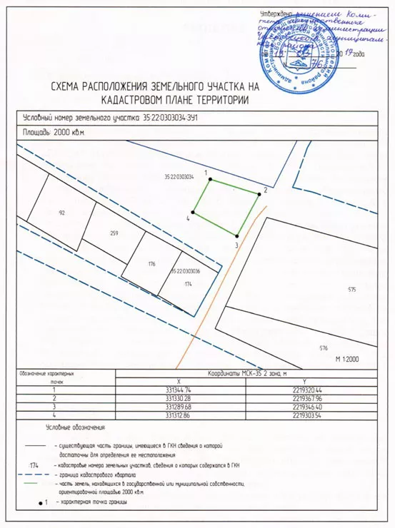
What is displayed in the layout of the land plot on the cadastral plan of the territory?
The location plan of the land plot on the cadastral plan of the territory (a sample can be seen below) is drawn up in the form of a topographical drawing, which looks like the configuration of the plot, with text support. The customer receives a paper version of the document on a sheet of A-4 format, and transfers an electronic version certified by a special electronic seal of the work contractor to the State Budgetary Inspectorate department.
It has a different structure, depending on the purposes of land surveying and the legal capacity of cadastral action:
- When allocating (cutting) land, the boundaries of the corresponding plot are reflected, drawn by a red line in the places where the boundary lines pass. The same applies to other situations that do not allow reorganization.
- When making extensions , the document includes the previous configuration and the new boundary boundary, outlined by a red line.
- When dividing a land plot into two or more – the boundaries of the previous plot and the boundaries of the newly formed plots highlighted with a red line.
- When merging , a plan of the plots that formed a single land plot, limited by the red line of the newly established boundaries.
In addition to the drawing indicating the configuration of the boundaries, the document is provided with text support. It contains important cadastral information, such as:
- total storage area;
- coordinates of turning points;
- applications (acceptance certificates, approval of boundaries, etc.)
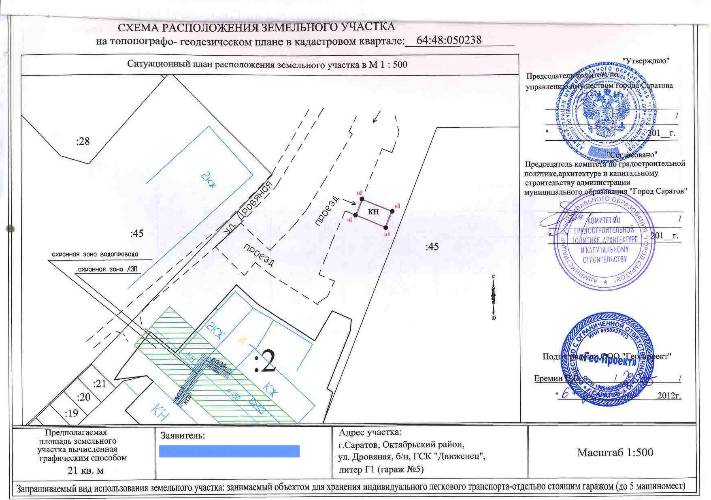
Samples of a plot of land on a cadastral plan of the territory
Layout of a land plot on the cadastral plan: a sample of several copies (click on the picture to get its full size).
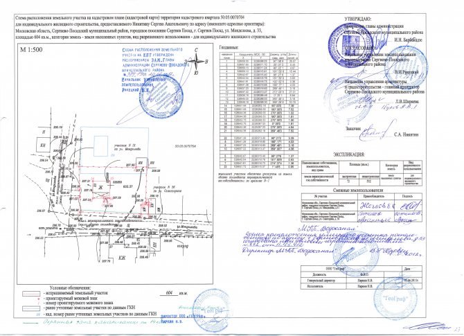
Scheme of the land plot on the cadastral plan of the territory
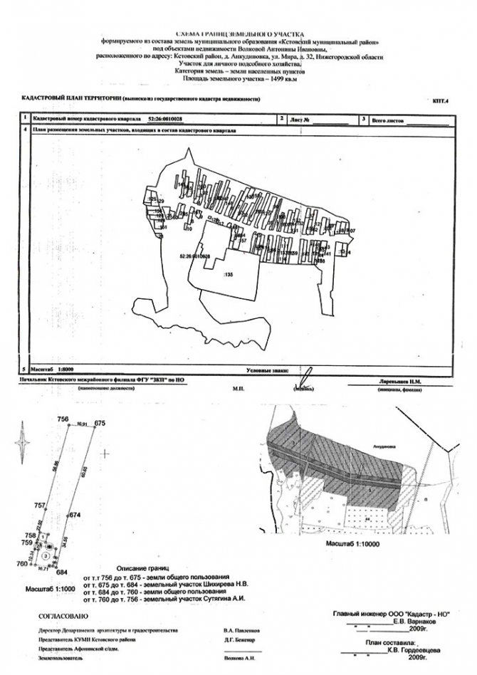
Sample: diagram of land boundaries
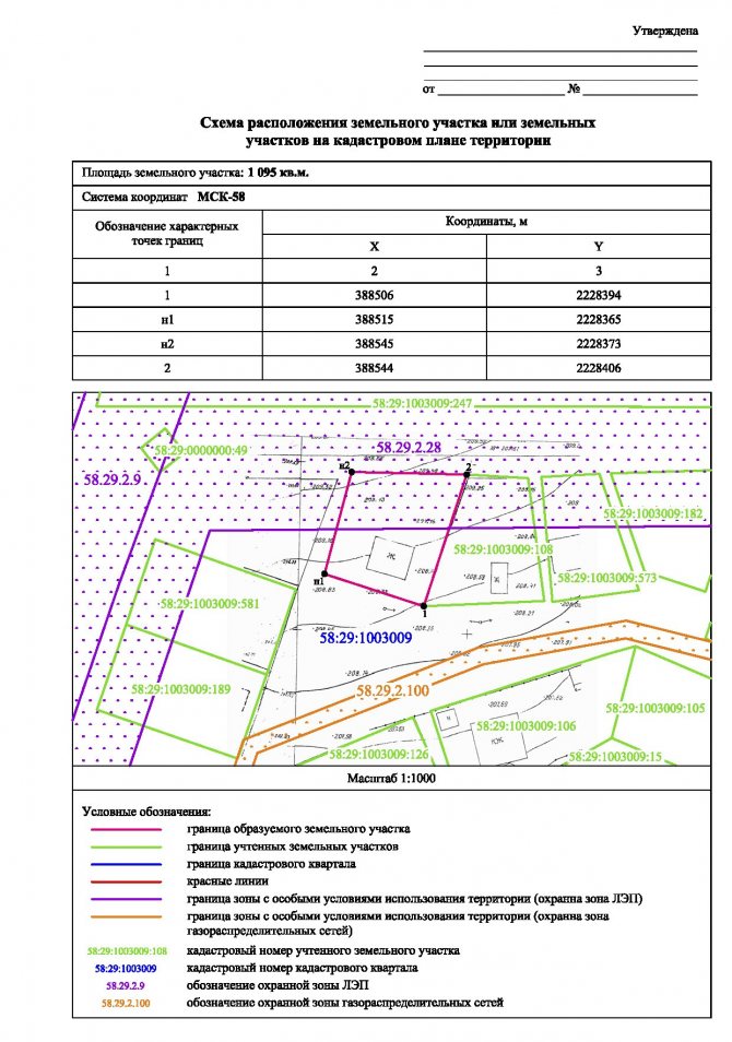
Layout of the land plot on the cadastral plan of the territory: Form 4
Stages of preparing the storage layout diagram
To obtain a diagram of its location, the initiator of the formation of a land plot must act in the following order:
1. The interested party prepares a statement about the need to prepare a layout plan for a plot of land. The basis for this is a document confirming the authority of the applicant regarding this plot.
2. A package of documents is prepared that must be attached to the application. It includes:
- applicant's passport;
- title document for a plot of land (certificate of ownership, act of allotment of land, etc.);
- cadastral passport for land (if available) or extract from the Unified State Register of Real Estate;
- a certificate from the BTI, if there are buildings on the site, or a cadastral extract, if there are none.
Order an extract from the Unified State Register of Real Estate
3. The application with documents is sent to the cadastral engineer. Before starting work, a contract for the provision of services for the production of the circuit is drawn up.
4. The received documents are analyzed by a specialist for the presence or absence of grounds for refusal to approve the layout of the storage unit. To do this, he requests the registration data of the site in the form of a cadastral extract.
The diagram can be prepared in one of the following ways:
- Analytical.
- With a specialist visiting the site.
In the first case, preparation is carried out office-wise. The boundaries of the storage area are roughly designed and a layout diagram is prepared. In this case, there is a risk that after approval and registration of the right to the plot, you will receive an allotment that is not within the boundaries that you want. This is especially dangerous if there are some other real estate objects around the site you have chosen (other people’s sites, buildings, etc.). If there are risks of crossing the boundaries of someone else's property, it makes sense to prepare a diagram with a surveyor visiting. It's a little more expensive, but well worth the money if the land overlaps with neighbors.
Upon departure, the surveyor will determine the exact coordinates of the boundaries of this site and a diagram will be prepared based on them.
5. Receipt of an official document. Its preparation usually takes from two to four weeks.
After approval, the cadastral engineer can prepare a boundary plan and conduct cadastral registration of this newly formed plot. At the exit, you will receive a registered plot with a cadastral number, and an extract from the Unified State Register will be issued.
After this procedure, you can begin the process of registering the right to a piece of land and you will have a property. Before cadastral registration, there can be no talk about a real estate object, since in accordance with Russian legislation, a real estate object arises after its cadastral registration and the appearance of a cadastral number.
A citizen can independently prepare this scheme using the Rosreestr portal. But not everyone has all the necessary information to check compliance with all regulations. This is a fairly large amount of information that a cadastral engineer usually has. Therefore, it is recommended not to waste time and contact qualified specialists.
Sample SRZU for KPT 2021 :
Step-by-step instructions for obtaining a memory location diagram
Receipt of this document is associated with the interest of the copyright holder of the site, which can be either an individual or a legal entity. To answer in detail the question of how to make a diagram of the location of a land plot on a cadastral plan, we will learn about the grounds for preparing the plan.
Reasons for preparing the diagram
The main reasons for formatting a document are::
- an application submitted by an interested person;
- the legal capacity of the applicant;
- legal capacity of the land plot.
Legal capacity is confirmed by documents and requires proof of ownership of the site and authority to carry out the declared actions.
Providing documentation
A package of documents is attached to the application for obtaining a diagram of the location of a land plot on the cadastral plan-map of the territory. Among them:
- the applicant's civil passport;
- certificate of ownership;
- in the absence of a certificate - a certificate (act) about the allocation of land;
- cadastral passport of the land plot;
- cadastral extract about the absence of buildings;
- if there are buildings - a certificate from the BTI.
If the site is in joint shared ownership, applications from all co-owners will be required. When a representative acts in the interests of the owners, he presents his civil passport and a notarized power of attorney issued by the title owner of the land plot.
Who provides the preparation of the scheme?
The document is prepared and certified by a cadastral engineer, whose services you can apply for:
- in a private geodetic company;
- in the multifunctional center (MFC).
By contacting the designated authorized authorities, you should submit an application and attach copies certifying ownership of the site and reflecting its main characteristics.
Information and information taken into account when preparing the diagram
The plan diagram reflects reliable information, negating the permissibility of errors in determining the boundaries of the memory . Therefore, the cadastral engineer receives preliminary information from the registration records of the State Property Committee in the form of a cadastral extract. It reflects data on the location of the site in accordance with the information bank data. Since they must coincide with the real state of affairs, excluding cadastral errors, a geodetic survey of the site is carried out.
After comparing the cadastral records with the data obtained during the geodetic survey, an official document is drawn up that corresponds to the purposes of the request when ordering land surveying services.
We also recommend that you read our other materials and find out:
- What is land surveying?
- What documents are needed?
In addition to the coordinates of boundary boundaries, the preparation takes into account:
- surrounding context;
- permanent buildings on the site and beyond;
- engineering Communication;
- transport lines passing close to the storage facility.
Preparing the storage layout diagram
The document preparation process consists of three stages:
- Preliminary planning based on an extract received from Rosreestr . Drawing up technical specifications.
- Geodetic survey . Analysis of the information received and its comparison with the accounting data indicated in the extract.
- Office work . Based on the information received, drawing up a diagram of the location of the memory in the surrounding context, highlighting the boundaries. Preparation of a report and accompanying documentation.
Each stage is essential for obtaining and transmitting reliable information that forms the boundary matter. The basis of the survey documentation package is a plan diagram with applications in the form of tabular forms and explanatory notes that reveal the specific characteristics of the site.
Dates of issue
Document preparation takes from two weeks to one month. If the company has a waiting list, the deadlines increase. They are specified in the service agreement and require compliance.
Cost of work
The assessment of services is included in the cost of land surveying, which for standard plots of up to 10 acres is limited to 5-7 thousand rubles. This cost is set for lands that have 4 turning points - that is, an even geometric shape. In other cases, the payment amount is calculated individually.
When reorganizing plots, re-registration of property rights is required, which requires payment of a state fee to Rosreestr. In this case, individuals pay a fee of 2 thousand rubles. and legal entities – 22 thousand.
Registration of SRZU by the administration
In most cases, the initiator of the preparation of the scheme is an interested person: an organization or a citizen. The territorial administration is only obligated to formalize it in the event of the sale of a plot through an auction. The applicant bears all costs associated with the production and receipt of the SRZU.
The body allocating land sends an electronic scheme to Rosreestr. This is necessary so that no other plot is formed on this site until the rights to it are registered or in the next two years (the period of validity of the scheme).
A violation on the part of the administration is the requirement for the applicant to submit the scheme in electronic form. This requirement is illegal!
Grounds for refusal to approve the scheme
There are not many reasons, but enough to get on the nerves of the “possible buyer.” Sometimes it seems that it is not profitable for executive authorities to provide plots on a paid basis, because they are reluctant to approve the scheme. They often refuse for various far-fetched reasons. Perhaps, if the scheme was not accepted the first time, the administration has its own plans for the requested site.
They will refuse if:
- the circuit does not meet the approved requirements (the most common reason)
- the boundaries of the formed plot intersect the boundaries of another plot registered in the cadastral register or the scheme of which was previously approved before its expiration (this happens very rarely, since these boundaries are taken into account when preparing the scheme)
- the area being formed does not meet the requirements of the Land Code (can be found here)
- the site is located in the area where there is a land surveying project (sites are formed only in accordance with this document)
- the boundaries of the site do not correspond to the territory planning project or land management documentation.
Reasons for refusal
In order for the scheme to be approved, it must comply with the requirements of the land code and, accordingly, should not meet the points that constitute grounds for refusal of approval. If the document meets all the requirements of urban planning regulations and legislation, then local government authorities are required to approve it.
According to clause 16. Art. 11.10 LC, reasons for refusal may be if the circuit:
- does not comply with the format or requirements for its preparation;
- has violations of the requirements of land legislation for the created plots;
- does not comply with the approved territory planning project, as well as the regulations on specially protected natural zones, urban planning standards;
- has other violations of land legislation.
They will also refuse if the boundaries of the area being created are:
- cross another plot already registered in the cadastral register;
- cross the boundaries of a land plot for which a scheme has been approved with a valid period;
- do not comply with the territory planning project or land management standards;
- within the approved survey project. In this case, it will become a problem to obtain the desired plot of land for rent or ownership. The solution here would be to include it in the project.
What to do if you receive a refusal?
Further actions of the person interested in receiving the scheme depend on the grounds on which the refusal was received.
In case of refusal due to a discrepancy between the data and the Rosreestr databases (cadastral error), you must submit a request to correct them. An option could be making changes and receiving an extract or refusal. Refusal must be submitted in writing, indicating the reason. Then with this document you can go to court, which, by its decision, will oblige the Rosreestr body to make changes.
If the administration refused to approve the layout of a plot of land due to non-compliance with the legal format or violation of preparation rules, then the applicant has the right to start the procedure again. This can be done again with the same cadastral engineer or contact another.
Reasons for refusal to approve the layout of the land plot
Often, the administration on whose territory the requested land plot is located does not accept the land plot schemes the first time. The document may need to be revised. There is no need to worry about this and argue with responsible employees. It should be clarified what exactly the officials are not happy with. You may just need to make minor adjustments to the legend.
They also refuse for far-fetched reasons. Of course, the administration may have its own plans regarding the requested territory. Then the applicant will be bullied for years until he himself renounces his claims to the land. There are few reasons to refuse approval of the plan, but enough to get on the nerves of interested parties.
Refusal is allowed if:
- the document does not comply with the approved requirements of Order No. 762 of the Ministry of Economic Development;
- the boundaries of the plot being formed cross the boundaries of another plot that is already registered in the cadastral register;
- the boundaries of the created plot intersect with the boundaries of another plot, the layout of which has been approved and its validity has not expired;
- the allotment being created does not comply with the requirements of current legislation;
- the boundaries of the site contradict the area planning project or land management documentation;
- The land plot is located in the area where the land surveying project has been approved. The reason for such a decision is usually the discrepancy between the site described in the attached diagram and the approved land surveying and planning project. In this case, obtaining ownership or lease of land in the specified location will be very problematic. The only solution is to include the site in the project.
What to do if the Administration refuses to approve a land plot plan
Coordination and approval of the layout of the land plot
The finished scheme is subject to mandatory approval by authorized bodies. In particular, the finished document, executed in electronic or paper form, must be agreed upon:
- executive authority of a separate subject of the state;
- local government body.
This rule, by agreement, applies in all cases, with the exception of some established at the legislative level.
Based on the results of reviewing the scheme, the authorized body makes a decision that can either approve it or imply a refusal to approve it.