What it is?
A cadastral passport is a document in paper or digital form on which the exact boundaries of a land plot are marked with an acceptable error of no more than 5-10 cm.
Such a plan is drawn up not only for land plots. Other types of real estate, for example, buildings, structures, are also subject to appropriate accounting, but they are connected to the land and are taken into account in the plan in direct connection with the site. In fact, this is the basic document for cadastral registration of real estate.
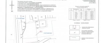
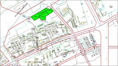
This is what a cadastral plan of a land plot looks like:
Grounds for obtaining a cadastral plan
Not everyone can obtain a cadastral plan from Rosreestr, but only those who are the owner of a given plot. Even if a citizen living on the site, but not the owner, manages to collect all the necessary documents, he will be denied the issuance of a cadastral plan. Thus, there must be compelling reasons for issuing a cadastral plan. These include:
- You bought a plot, but at that time the cadastral passport was not issued. Such cases occur in practice. The documents may simply be lost by the former owner. In this case, the owner must contact the cadastral chamber, presenting a document confirming the emergence of ownership rights (bill of sale, will, deed of gift, etc.). If you yourself have lost your cadastral passport, you will have to pay a fine.
- The right of ownership arose in the process of purchasing land from the state. It happens that municipal lands are sold to citizens, but since they have not been used in any way until this moment, there are no documents for them. In this case, the new owner will have to go through all the registration steps independently.
The main basis for drawing up a cadastral plan is the separation of this site from some other site. In this case, you have to draw up a new cadastral plan. If there is a change of owner, the cadastral plan requires its re-registration.
Kinds
This document has several functions, depending on which it is divided into types:
- Mezhevoy. This is one of the components of land surveying, which consists of textual and topographical elements. Necessary to clarify the configuration, area, as well as the exact boundaries of the site in the general area.
- Technical plan of the land plot. This document also consists of two parts: text and graphic. The text contains information about the location of the object and its main characteristics.
- Duty cadastral map. Contains information on the territorial zone of the location of the area of interest. The data is presented in the form of schematic images.
- Derived map. Contains information about the land area indicating natural and social processes.
- Public plan – available online. Makes it possible to obtain information about the address of the object.
All varieties of the corresponding plan are mostly interconnected. For example, a room plan is always made on the basis of a floor plan, which in turn can be based on a previous document of unfinished construction and on a boundary plan.
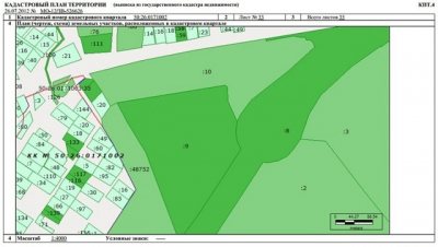
What does the document look like and how is it read?
The designated document is issued not only for land plots, but also for all types of real estate (country house, apartment). The cadastre plan is a map of the designated area, drawn up using topographic equipment and special tools. Therefore, errors in establishing boundary boundaries are minimal.
A pressing question for landowners, as well as property owners, is how to read the cadastral plan correctly and what it should look like? This is not so difficult, because in addition to topographical diagrams, it contains text information in the form of data decoding. The example contains the following information:
- B.1 – full characteristics of the property are indicated.
- B.2 - is a plan diagram of the existing boundaries of the site itself, as well as its individual parts.
- B.3 – the presence or absence of encumbrances and easements is indicated.
- B.4 – plan-drawing, which marks the boundaries of a plot of land in graphic form.
- B.5 – data is displayed, the description of which includes not only the memory itself, but also those adjacent to it. Landmarks of the area where the immediate boundaries lie are marked.
- B.6 – duty turning points and nodal points of the designated plot of land and all its parts are registered.
Contents and sections
The plan structure consists of five main parts:
- General information about the site. This includes general information about the site, ownership rights to it, physical and cadastral information about this site.
- Plan diagram. The diagram shows in detail all the existing boundaries of the landowner, which is registered with the state.
- Text describing the boundaries of the site, as well as turning points and their coordinates.
- Text information about the presence of parts of the site, if any.
- Graphic and schematic information about the site, with the help of which it is possible to determine the area of the object.
Important! The written part of the document must contain clarifications about where and when this site was registered.
To clarify the boundaries, the text description indicates all natural objects that can be used to visually link the site to a specific area.
Form of cadastral plan of a land plot in the cadastral passport
The entire cadastral passport of a real estate property consists of 4 forms:
IN 1
It contains all general information about real estate in the cadastral quarter. The first form is a table with the following information:

- the name of the authorized body responsible for registering the land plot with cadastral registration;
- plan registration number;
- cadastral number of the property;
- address of the location of the land plot;
- information about rights to the site;
- type of property;
- square;
- category of land;
- type of permitted use;
- purpose (designed purpose);
- cadastral value in rubles;
- information about the areas with which the land plot borders.
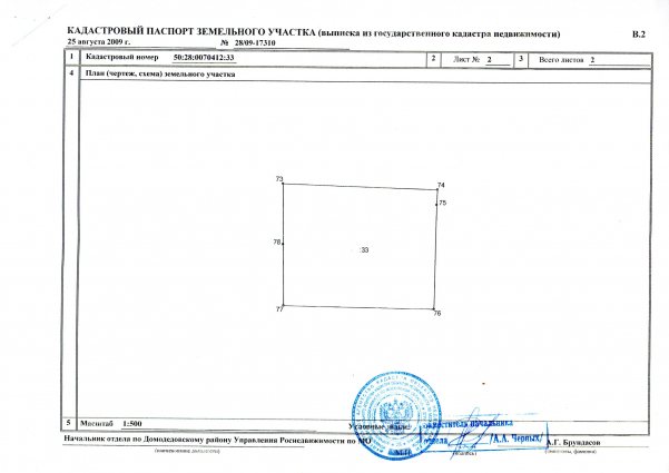
AT 2
This form of cadastral passport reflects the cadastral plan we are considering. The site plan is depicted schematically, provided that land surveying has been carried out. If land surveying has not been carried out, no information will be provided on this form.
B.3 and B.4

These forms contain data on existing restrictions (encumbrances) on the use of land.
For example, the land plot is located in the area of a water protection zone or a protection zone of laid communications. If there is no information about restrictions in the Unified State Register of Real Estate, then when ordering a passport, forms B.3 and B.4 will simply not be included in the document. Thus, the cadastral plan is one of the two main forms of the entire cadastral passport. The first form displays textual information about the plot, and the second contains a graphical form of the land plot. The remaining two forms are added only if there are any restrictions on the use of the land.
How to find out the number?
All necessary accounting information is currently available online. To obtain certain certificates, you need to know the cadastral number of the land plot. It can also be found online.
How to check by owner's last name?
It is impossible to find out the corresponding plot number just by the owner's last name. There may be many people living in one country or region with identical surnames, as well as similar first and patronymic names. Therefore, in addition to the owner’s last name, you will also need the address of the storage unit. Federal Law No. 152 “On the Protection of Personal Data” also plays a role.
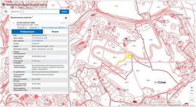
How to look at the address of an object (house)?
It is easier to find out the cadastral number by the address of the property. To do this, you need to refer to the public map https://kadastrmap.ru/. In the upper window, enter the full address of the object and press the “Find” button.
As a result, you can find out the following information for a specific object:
- object status;
- exact area;
- cost according to the cadastre;
- type of ownership;
- the date when the object was registered in the cadastral register;
- main characteristics of the object.
Reference! The cadastral number includes the number of the territorial block on the territory of the Russian Federation, as well as the number of the district, district and the site itself.
Do you need to do land surveying to get it?
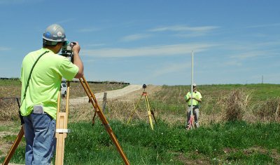
To establish and clarify boundaries, land surveying is mandatory. Without this procedure, it is impossible to register a land plot with the Cadastral Chamber.
The cadastral plan differs from the boundary plan, but the cadastral plan has ceased to exist as technical documentation, so land owners should check their technical documents for real estate to clarify their relevance.
What does a cadastral plan of a land plot look like?
The cadastral passport has an approved form.
You can download the cadastral plan (sample) for a land plot in XML format here (all files are in a .zip archive).
Land surveying can be done free of charge until January 1, 2021. Do you need to draw up an act of delineating the boundaries of a land plot? Our article contains detailed instructions. Donating part of a land plot and part of a house has its own characteristics. You can read more about them here.
Where can I get it and how can I get it?
You can obtain the relevant document either in person or using online services. There is a certain procedure for this, depending on where the owner of the land plot will apply.
Personally
The provision of a passport for a land plot is regulated by several legislative acts:
- Federal Law of July 27, 2010 No. 210-FZ “On the organization of the provision of state and municipal services.”
- Federal Law of July 24, 2007 No. 221-FZ “On the State Real Estate Cadastre.
- Decree of the Government of the Russian Federation dated June 10, 2009 No. 457 “On the Federal Service for State Registration, Cadastre and Cartography.”
Attention! According to the Land Code of the Russian Federation, since 2018 it is prohibited to conduct any transactions with land without a cadastral passport for the land plot. To obtain the required document, you must contact the appropriate authority.
Through MFC

To obtain a cadastral plan through the MFC you must:
- Complete the paper application in person with the required documents.
- Contact the MFC. If the plot is registered, then the state duty will be 200 rubles, for a plot that has not been registered - 350 rubles according to the Tax Code of the Russian Federation, Art. 333.33.
Through Rosreestr
Rosreestr is another body authorized to issue the necessary document. To receive a plan you must:
- Contact the territorial office of Rosreestr with a completed application and all necessary papers.
- After the applicant has provided all the documents, the Rosreestr employee gives him a receipt, which the applicant will then provide upon receipt of the corresponding passport for the land plot.
- You can also submit documents to Rosreestr by mail.
Via USRZN
USRZN is a Unified Information Service where you can personally or through your representative obtain the necessary document for a specific land plot. The algorithm is the same as in previous cases.
Online
Ordering a plan through online services has a number of undeniable advantages:
- this treatment significantly saves money and time;
- Obtaining a cadastral passport takes a few minutes;
- electronic and paper forms of the document have equal legal force;
- The payment for the electronic service includes a state fee.
The algorithm of actions is simple:
- Go to the website https://www.rosreestr.ru.
- In the “Government Services” section you need to find the line “Obtain an extract from the Unified State Register of Real Estate on the main characteristics and registered rights to the property.”
- Fill out the online form.
- Pay the state duty in accordance with the Tax Code of the Russian Federation, Article 333.33.
Then you need to track the status of the request in your personal account.
The video below explains how to get a cadastral plan for a land plot online:
Features for forest area
According to the current legislation of the Russian Federation, namely under Art. 92 of the LC RF, forest lands are allowed to be registered accordingly only if they are used for recreational activities , for example:
- organization of sanatorium holidays;
- tourism;
- sport fishing and hunting.
In other respects, the preparation of cadastral documentation is not much different from standard actions, since such forest lands are equated to land. Be sure to indicate in the land use category section that this is forest land.
Extract
An extract from the land plot plan in question is a document that contains all the information about the land plot, including information about who its owner is. A similar passport contains less information than an extract. In this case, an extract can only be issued for a registered plot. The form of the extract is regulated by order of the Ministry of Economic Development of the Russian Federation No. 831 dated December 28, 2012.
The cadastral plan for a land plot is a mandatory document for a number of actions with a land plot. It is also necessary for registering the land with cadastral registration. It displays complete information about the site and is an integral part of the cadastral passport, which is used in any real estate transaction.
We tried to write the best article. If you liked it, please share it with your friends or leave a comment below. Thank you! Great article 2
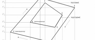
Why do you need a layout diagram of a land plot at KPT?
The scheme itself is not a legal document. It is technical in nature and requires:
- to form a land plot from lands or other plots that are in state or municipal ownership, i.e. not privately owned;
- in the case of redistribution of land plots that are privately owned with state or municipally owned lands, the so-called addition.
The most common cases when preparing a memory layout diagram is required:
- required by a cadastral engineer to prepare a boundary plan in order to register it with the cadastral register and obtain the cadastral number of the plot;
- you own a state-owned plot on lease and want to divide it. In this case, approval of the scheme for dividing such a plot is required;
- want to register an empty plot of land that does not belong to anyone, receive it for rent or ownership (purchase) in accordance with the land code.
- may be required if a building permit is obtained.
In other cases, land is allocated by local authorities in accordance with the land surveying and planning project.
The scheme is approved for a certain period of time; according to the law, the period is 2 years .