Clarification procedure
Clarification of the boundaries of land plots is a special type of boundary work, the result of which is a boundary plan of the plot drawn up by a cadastral engineer, which indicates the updated boundaries.
According to paragraph 10 of Art. 22 of the Federal Law “On State Registration of Real Estate” No. 218, clarification of the boundaries of land plots is carried out in the following cases:

- The boundaries of the site have not been established;
- The documents do not contain data on previously defined boundaries;
- The boundaries of the site are established with insufficient accuracy.
The first case refers to a situation where the purchased plot of land does not have a cadastral document indicating the boundaries of the plot.
In the second case, a cadastral document is available, but it is necessary to clarify the boundaries due to the lack of a boundary plan, since a cadastral document for a plot can be obtained within the general boundaries determined by the territory surveying project (especially when providing a garden or dacha plot).
It is important to remember that even if you have a cadastral passport and a boundary plan (the third case), the procedure for clarifying existing boundaries will help to avoid troubles with the owners of neighboring plots or if it is necessary to divide the plot into several independent plots.
Unified land use - legislative framework
Today, EZ status is not assigned , since state law No. 221 came into force in 2007, according to which the concept of multi-circuit sections was introduced. Today this status is an alternative to EZ. Consequently, EZ status was assigned to lands until 2007. Land plots that fell under the definition of Unified Land Use were not transformed until 2007. Therefore, today they fall under this status.
We recommend reading: Free notary consultation online
Previously, large agricultural associations and enterprises owned large plots of land, which in turn could be divided into separate plots. There are many examples when lands were assigned the status of single land use.
Required documents
Before carrying out work to clarify boundaries, you need to collect the following documents:

- Certificate of right to use the plot;
- Cadastral document (if available);
- Allotment development plan;
- A copy of the territory surveying project;
- Copy of the passport.
The land surveying project is in the hands of the local executive authority, which previously provided the land for construction or development. If the land was provided to a garden or dacha partnership, then a copy of the land surveying project can be obtained from the SNT board.
A development plan is necessary to clarify the possible excess of the maximum proximity of future buildings to the updated boundaries.
You need to know that the following persons have the right to carry out work to clarify and redefine boundaries:

- Owners of plots;
- Tenants;
- Holders of the right to perpetual use of the allotment;
- Holders of the right of lifelong inheritable ownership.
These persons must have documents confirming the right to use the plot.
You should know that in accordance with Part 2, Clause 1, Art. 29.1 of the Federal Law “On Cadastral Activities” No. 221, a cadastral engineer may refuse to carry out boundary work if the customer provided an incomplete package of documents, or the documents contained inaccurate information.
Clarification of unified land use in the program “Polygon: Boundary Plan”
When drawing up a boundary plan to clarify a single land use, many questions and doubts arise. In this article we will show how to create a boundary plan to clarify a single land use with the inclusion of newly formed areas with clarification of adjacent areas. As a tool, consider the program “Polygon: Land Survey Plan”
, with the help of which you can quickly and easily create a boundary plan of any complexity.
Computer program “Test Range: Land Survey Plan”
serves to automate the filling out of a boundary plan - documents and drawings for registering land plots with cadastral registration with the generation of both printed and electronic documents (XML files), as well as the creation of a ZIP archive for submission to the cadastral registration authority or sending it from the program to Rosreestr.
The program is developed in accordance with the following regulatory documents:
- Order of the Ministry of Economic Development of Russia No. 412 dated November 24, 2008. “On approval of the form of the boundary plan and requirements for its preparation, an approximate form of notice of a meeting to agree on the location of the boundaries of land plots” as amended by Order of the Ministry of Economic Development of Russia No. 32 dated January 25, 2012.
- An XML schema used to generate an XML document - a boundary plan of a land plot, submitted to the cadastral registration authority in the form of an electronic document. Approved by Order of Rosreestr dated June 25, 2013 No. P/237. Version 04 (versions 03 and 02 are also supported).
The program allows you to draw up boundary plans for all types of cadastral actions provided for in the form of a boundary plan: formation of land plots [1] by division, allocation, redistribution, consolidation, formation of land plots from lands, formation of parts of land plots, clarification of land plots, clarification of the boundaries of adjacent land plots, correction cadastral error.
The program works both with ordinary land plots (land uses), and with plots that are part of the EZ [2] (separate, conditional plots), multi-circuit land plots, incl. with areas that have internal boundaries.
Working in the “Polygon: Boundary” program you can get:
- electronic document of the boundary plan (XML file);
- printed forms of documents;
- A ZIP archive containing all submitted files: XML, application files[3], as well as their electronic signatures.
The program creates all these documents automatically based on the entered initial data. The XML document and the generated ZIP archive are checked for correctness of completion, as well as for compliance with the Order and the approved XML schema.
In "Polygon: Boundary Plan"
It is possible to send a boundary plan to Rosreestr directly from the program.
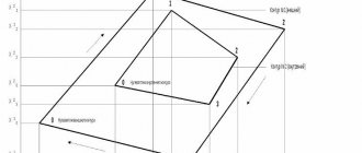
Before we begin to consider the boundary plan, let us recall how a single land use differs from a multi-circuit plot. In the State Land Cadastre, it is customary to define a single land use as a composite land plot, which is assigned a single cadastral number, and which consists of two or more separate land plots, which also have their own cadastral numbers.
Multi-circuit land plot
- this is a land plot, the boundary contour of which consists of 2 or more closed contours. A multi-circuit memory unit is assigned only one cadastral number. According to clause 89 of Order No. 412 of the Ministry of Economic Development, the designation of the contour of a multi-circuit land plot is given in the form of a designation (or cadastral number) of the land plot and a number enclosed in brackets - the serial number of the circuit, written in Arabic numerals, for example, 19:01:010203:123(1), 19:01:010203:124:ZU1(1), :ZU1(1).
The program is controlled using the toolbar, and the current action that the program is performing and the result of its completion are displayed in the status line. The information panel displays a hint about the item from the Order corresponding to the field being filled in.
The boundary plan consists of sections. Each section is presented in the program with a separate tab. Sections that are mandatory are immediately available for completion. To add a new section, there is a button on the toolbar - “Add section”
.
Rice. 1. Main window of the program “Polygon: Boundary plan”
We will show you how to create a boundary plan in the “Polygon: Boundary Plan” program using the new XML schema version 04. To select the desired version of the scheme, click on the button – “Change XML Schema Version”
.
Let's start filling out the information from the “Title Page” section. Fill in the required field “! 1. The boundary plan was prepared as a result of the implementation of cadastral work in connection with"
(required fields are marked with a “!”), we will enter information about the customer, information about the cadastral engineer, which are filled out in a separate form that opens when you click on the “Fill” button, then fill in the details
“*Date of cadastral work”
. The program will remember information about the cadastral engineer for the next land survey plan.
The source data must be entered on the “Source” tab. We enter the documents on the basis of which the boundary plan was drawn up in table “1. List of documents used in drawing up the boundary plan.” The list of these documents can be copied to the “Contents” tab; to do this, place the cursor in the “Appendices” table and click on the “Calculate/Fill”
.
Fig.2. Section "Initial data"
To clarify the boundaries of land plots that are part of a single land use, we will add a section “Clarified”
.
1. Let’s fill out the first tab “To be specified” directly for the single land use as a whole. It is necessary to indicate the cadastral number in the field “Cadastral number of the land being specified”, the cadastral quarter, the area and the error of the unified land use. In our example, newly formed areas are included in the ED, so we will enter (or import) their points into the table with coordinates. If the formed areas have parts, we will indicate the coordinates of the parts. To fill in information about parts of boundaries, click the button – “Calculate/Fill”
.
Rice. 3. Tab “To be specified”, filled in on the EZ
At the bottom of the window you need to check the box “*Upload to the branch “Composition of a single land use” (ExistEZParcels)”. If the composition of a single land use does not change (but only the coordinates of the points of previously existing areas included in the EZ are specified), then tables “a)*Information on existing isolated and conditional areas included in the EZ”, “b)*Information on new isolated and conditional sections included in the EZ” and “c)* Incoming sections excluded from the EZ” do not need to be filled out. In our example, it is necessary to fill out the table under the letter b), which is filled in automatically using the “Calculate/Fill”
.
“Refinable” tabs
, how many separate (conditional) land plots that are part of the EZ need to be clarified. On each such tab, information about one separate (conditional) land plot is filled in: the indicated cadastral number, cadastral number EZ and other information. On these tabs, the “*Upload to the branch “Composition of a single land use” (ExistEZParcels)” should not be checked.
Fig.4. Tab “Refined” for a separate (conditional) area
Information about the EZ and the plots included in it can be imported from the cadastral extract of the land plot (in the “Open” button menu, select the “Import information from XML file...” command). As a result, many details of this tab will be filled in, including existing coordinates, boundaries, cadastral number and more.
Fig.5. Open button menu
In our example, newly formed land plots must be “cut out” from areas adjacent to the same land use, i.e. add internal boundaries to adjacent memories. For each adjacent land plot, fill out the “Updating” tab, where you need to check the box “Upload this section as information about clarifying the border of an adjacent land plot,” and also enter the cadastral number of the adjacent plot and other necessary information.
Fig.6. Tab “Refined” for an adjacent area
Select in the field “*Type of clarification of adjacent area”
from the list the value “Changing part of the border (from point to point), including adding an internal border (“hole”)” and in the table with coordinates we indicate the coordinates of only the internal border being added in the specified X, Y columns.
If necessary, fill out such sections of the boundary plan as “Information on measurements and calculations performed”, “Conclusion of a cadastral engineer”, “Act of approval of the location of the border of the land plot” and others.
Graphic sections of the boundary plan can also be quickly prepared in the “Polygon: Boundary Plan”
, for this:
- It is necessary to transfer the coordinates of points from the text sections of the plan to the graphic using the button – “Calculate/Fill”
. - Next, symbols, line types, and colors are selected. You can select the same color or sign by simply copying it in the table.
- In the diagram, you can show additional connections between points; for this, in the 2nd table, select the starting and ending points that need to be connected, the type of line, and to sign the distance in the “Sign distance” column, put “+”.
- To add a raster background to the “Open” button menu, perform “Insert raster from file”.
- Calculate the scale of the drawing ( – "Calculate/Fill"
).
Rice. 7. Tab "Drawing"
Using the button – “View graphics”
you can see the drawing. When viewing a drawing, you can select points, lines, and change their symbols.
Fig.8. View a drawing
According to the XML scheme version 04, in the “Drawing” section it is necessary to fill out the table “!* Attached files with images”, to do this, print the drawing and save it in pdf format (jpg, tiff), enter the file name in the specified table.
After all the steps have been completed, all that remains is to fill out the “XML” tab for the electronic document. We add the “XML” section; this section can be included in the boundary plan only in one copy. If it is not enabled, then uploading to an electronic document will not be performed. In this section, you must specify “!Type of information” - in our example, we will select “package of information with a statement of changes.” Check the box “Include digital signature files in the ZIP archive.”
Fill out the table “Attach files to a ZIP archive”
: for XML scheme version 04, click on the button -
“Calculate/Fill”
- the program will enter into the table the files specified on all other tabs of the boundary plan (for example, files of scanned documents), and for scheme 03 - manually select the files that will be attached in a ZIP archive.
Fig.9. "XML Upload" Tab
Creating an XML file of an electronic document
– click the button –
“Upload to XML”
– an XML file editor window will appear and a message indicating that the electronic document has been generated and saved.
Rice. 10. XML File Editor
If errors were detected during the formation of the XML file, the error and warning log window will open. Any errors found in the boundary plan must be corrected and the XML file regenerated.
Fig. 11. Error and warning log
Working with electronic signature (ES).
The “Polygon: Land Survey Plan” program signs files
with an enhanced qualified
electronic signature in accordance with the standards of Rosreestr and in accordance with Federal Law No. 250 of July 23, 2013 “On amendments to certain legislative acts of the Russian Federation regarding state registration of rights and state cadastral registration of real estate objects,” therefore additional no software required. All you need is an electronic signature key and a program containing Russian signature standards, for example, CryptoPro CSP.
All boundary plan files can be signed with one button: click – “Sign all”
, then select the signing certificate in the dialog window, after which the program will inform you that the files were successfully signed.
Creating a ZIP archive.
The ZIP archive is created according to the requirements of Rosreestr, specified in the order of Rosreestr dated June 25, 2013 No. P/237.
Click on the button – “Create ZIP archive”
. Upon completion, the program will offer to save the resulting ZIP file to removable media, or open the folder in which it was created. If any errors occurred during archive creation, an error log will be displayed on the screen.
Currently, the program has a unique opportunity to send boundary plans directly to Rosreestr. To send, you do not need to fill out a form on the Rosreestr website, or attach files, etc. – just click on the “Send”
. The results of processing the registration application can also be seen directly in the program.
In this article, we tried to briefly describe the most significant features of the “Polygon: Land Survey Plan” program. You can learn more about the program using the demo version of the program, which can be downloaded on our website.
In conclusion, I would like to add that “Polygon: Boundary Plan”
– the program is flexible and universal, and creating boundary plans of any complexity using this program is a fairly simple and fast process. If any difficulties arise, technical support specialists will always help you both in working with the program and in creating boundary plans.
[1]ZU – land plot
[2]EZ – single land use
[3]Attached files can be in *.jpg, *.pdf, *.tiff formats in accordance with Order of Rosreestr dated June 25, 2013 No. P/237.
| Go to Polygon Pro → |
| Program catalog → |
Procedure
If there is no cadastral passport for the land plot and a boundary plan, then the procedure for clarifying the boundaries of the plot is as follows:

- Collecting the necessary information and preparing documents;
- Choosing a surveying company;
- Initial inspection of the site by a cadastral worker;
- Concluding an agreement with the selected company;
- Carrying out boundary work on the site;
- Analysis of collected data;
- Approval of a preliminary map of the site;
- Drawing up the final boundary plan;
- Registration of the boundary plan in the cadastral chamber.
When preparing the above documents, it is important to find additional ones that contain any information about previously established boundaries. This may also be a technical plan of already constructed structures indicating their coordinates.
When choosing a geodetic company, you need to pay attention to the availability of the appropriate license, as well as the reputation of the company. The cadastral employee of the company must be on the federal list of cadastral engineers presented on the Rosreestr website.
First, a company employee inspects the site and studies the provided

documents, after which the customer and the company representative discuss the price and enter into an agreement, and also sign an act on the cadastral work.
Next, the cadastral engineer goes to the site with the necessary tools to take measurements; work on the site can last up to two weeks.
The cadastral engineer carries out the following actions on the site:
- Inspection of natural boundaries;
- Primary measurement of border lengths;
- Photographing the territory;
- Soil inspection;
- Installation of control points (pegs);
- Measuring the height of hills and/or the depth of lowlands;
- Clarifying measurement.
It is important to remember that before a specialist leaves for the site, it is necessary to notify neighboring users about the upcoming work to clarify the boundaries.

After the measurements have been taken and a number of necessary calculations have been carried out, the cadastral engineer provides a preliminary map of the site to the customer for approval. It is also necessary to agree on the newly defined boundaries with interested parties - co-owners of the customer’s plot and neighboring land users.
In the absence of claims from interested parties, the cadastral engineer draws up a final boundary plan for the site, which consists, in accordance with Part 5 of Art. 22 Federal Law “On State Registration of Real Estate”, in two parts:
- Graphic;
- Text.
The graphic part contains an image of the site plan indicating the new boundaries and places of passage/passage through the site under a public easement.
Interested parties must sign an act of approval of the boundaries of the land plot, which is located on the back of the graphic part of the final boundary plan.
After this, the agreed boundary plan is submitted to the state real estate cadastre for review and final approval, during which members of the review commission can make requests to the archives and check the authenticity of documents.
If violations are detected, the cadastral authority refuses to approve the final boundary plan indicating the reason.
The reasons may be:

- Incorrectly provided data;
- Incomplete package of documents;
- Detection of errors in the cadastral engineer’s calculations;
- Detection of the fact of overlapping boundaries;
- Inadmissible approach of borders to the red lines of the territory;
- Violation of a public easement.
To eliminate the overlap of boundaries or violation of the easement due to clarification, a court hearing may be required; other cases can be corrected by the applicant or cadastral engineer.
In case of successful approval, the customer receives a boundary plan with precisely defined boundaries, on the basis of which he can issue a cadastral passport for the land plot in the future.
It is important to remember that if information about the area of a land plot is entered into the Unified State Register of Land Registers, then the specified area cannot be less than that indicated in the Unified State Register of Land Registers by more than 10%, according to clause 3 of Art. 42.8 of the Federal Law “On Cadastral Activities” No. 221. Also, the area of the allotment with specified boundaries cannot exceed the maximum established sizes for lands of a given type or 10% if such limits are not established.
Cadastral Engineers Forum
Question: About the division of previously registered land plots, which were given the name “single land use” during state cadastral registration; on the legality of decisions taken by cadastral registration authorities to refuse to carry out state cadastral registration. Answer: MINISTRY OF ECONOMIC DEVELOPMENT OF THE RUSSIAN FEDERATION LETTER dated March 2, 2010 N D23-671
The Real Estate Department of the Ministry of Economic Development of the Russian Federation has considered the appeal regarding the division of previously registered land plots (hereinafter referred to as the original land plot), which were given the name “single land use” (hereinafter referred to as the unified land use) during state cadastral registration, and reports. In accordance with the Regulations on the Ministry of Economic Development of the Russian Federation, approved by Decree of the Government of the Russian Federation dated 06/05/2008 N 437, the Ministry of Economic Development of Russia is not vested with the authority to explain the legislation of the Russian Federation, as well as the practice of its application. At the same time, we believe it is possible to note the following regarding the issues raised in the address. The specifics of the unified land use section are established by clause 60 of the Procedure for maintaining the state real estate cadastre, approved by Order of the Ministry of Justice of Russia dated February 20, 2008 N 35 (hereinafter referred to as the Procedure). In accordance with this paragraph, when dividing a single land use, the formed land plots are assigned new cadastral numbers, and the original land plot (single land use) remains with the same cadastral number within the changed boundaries (changed land plot). It should be noted that the above rule applies only if, after the transformation of a single land use, at least two land plots remain in its composition. The Land Code of the Russian Federation (hereinafter referred to as the Code) and Federal Law dated October 25, 2001 N 137-FZ “On the entry into force of the Land Code of the Russian Federation” (hereinafter referred to as the Law) establish the following cases when, as a result of the transformation of the original land plot, one or more land plots, while the original land plot remains within the changed boundaries: - when dividing a land plot provided to a horticultural, gardening or dacha non-profit association of citizens (clause 4 of article 11.4 of the Code); - when allocating a land plot on account of shares in the right of common shared ownership of the original land plot (clause 1 of Article 11.5 of the Code); - when dividing a land plot that is in state or municipal ownership and provided to a citizen or legal entity (clause 18 of Article 3 of the Law). In relation to these cases, the current legislation does not provide for mandatory cadastral work to clarify the location of the boundaries of the changed land plots. Thus, when creating land plots in the above cases, clarification of the boundaries of the original land plot, including single land use, is carried out at the request of the customer of cadastral work. Additionally, it should be noted that parts 2 and 3 of Art. 24 of the Federal Law of July 24, 2007 N 221-FZ “On the State Real Estate Cadastre” (hereinafter referred to as the Cadastre Law) established that in the case of the formation of land plots as a result of a division in which the converted land plot is retained within the changed boundaries, the cadastral registration authority An application for registration and the documents necessary for cadastral registration are submitted only in relation to the land plots being formed. Accounting for changes in the converted (original) land plot, which remains within the changed boundaries, is carried out without an application within three working days from the date of state registration of rights to the land plots formed from it. On the issue of the legality of decisions made by cadastral registration authorities to refuse to carry out state cadastral registration (hereinafter referred to as decisions on refusal), it should be noted that the grounds for making decisions on refusal are established by Art. 27 of the Cadastre Law. At the same time, Part 13 of Art. 27 of the Cadastre Law provides that the decision to refuse can be appealed in court. Additionally, we inform you that the position of the Ministry of Economic Development of Russia on the specifics of preparing documents necessary for the implementation of state cadastral registration of multi-circuit land plots, the implementation of such registration and the provision of information from the state real estate cadastre on multi-circuit land plots was communicated to Rosreestr by Letter dated December 22, 2009 N 22409-IM/D23 .
We recommend reading: What you need to know when renting an apartment
Features of the procedure in the presence of a cadastral passport
The cadastral passport contains a schematic representation of the site indicating the main boundary points.
The presence of this document introduces a number of simplifying changes to the procedure for clarifying the boundaries of a land plot:

- Reducing the required package of documents;
- Reducing the number of boundary works;
- Having an additional argument in a dispute with neighbors;
- Simplified approval of the final boundary plan in the cadastral chamber.
If you have a cadastral document, you do not need to present diagrams of buildings and a land surveying project; the cadastral authority will request extracts from this project independently in case of doubt during the final approval of the land survey plan.
Survey work to clarify the boundaries directly on the site takes several days due to the absence of the need to carry out many preliminary measurements to determine the primary boundaries. Clarification of standard rectangular garden plots in the absence of disagreements takes one business day.
It should also be understood that if neighboring land users have ordered boundary work, then if a dispute arises, the advantage will be on the side that has a cadastral document with a schematic depiction of the boundaries. If both sides of the dispute have it, then the issue is decided by the court.
At the final stage of clarifying the boundaries, when they are agreed upon by the cadastral authority, such approval occurs much faster than in the absence of a cadastral document, and the likelihood of refusal of approval is reduced.
Order of the Ministry of Economic Development of the Russian Federation dated November 24, 2008
The boundary plan is drawn up in the form of one or two documents. A boundary plan is drawn up as one document if one or more land plots are formed as a result of division, redistribution, or allocation of a share; information about land plots and their boundaries is clarified. If land plots are formed by clarifying the location of the boundary of the original land plot, a boundary plan is drawn up to clarify the location of the boundary of the land plot and a boundary plan for the formation of land plots.
To draw up a boundary plan, a cadastral extract of a land plot, a cadastral plan of the territory, cartographic materials and land management documentation, and other documents are used. Depending on the grounds for the formation of land plots, a package of accompanying documentation is attached to the boundary plan.
How to draw up a statement of claim for clarification
If, during the process of clarifying the boundaries of the plot, the boundary plan of the plot was not approved by the cadastral chamber, or part of the plot of land of the land user was illegally seized by neighbors, then such a dispute is resolved in court.
Application structure
The statement of claim to the court has a certain structure, consisting of three parts:

- Introductory;
- Motivational;
- Petitioning.
The introductory part describes the situation that gave rise to the dispute, indicating supporting data. The reasoning part lists the laws and regulations applicable to the situation presented by the plaintiff in legal practice, as well as exactly how they can be applied, in the opinion of the plaintiff (or his lawyer).
In the pleading part, the plaintiff asks the court to resolve the situation in his favor on the basis of the laws and listed circumstances set out in the reasoning part of the application.
Land lease for 49 years with subsequent purchase can only be provided to citizens of the Russian Federation. Do you want to rent land for private plots? How to do this correctly is described here.
Non-residential premises can be converted into residential premises. The detailed algorithm is in our article.
What is boundary clarification?
Clarification of boundaries is possible only in relation to a previously registered area , that is, the area that was previously registered in the Unified State Register of Real Estate (GKN).
The easiest way to find out whether a plot has previously been registered is the public cadastral map of Rosreestr, which contains information about all registered plots of the Russian Federation.
You can also check the registration of a land plot through the online reference service of Rosreestr.
To do this you need to know at least one of the following points :
- Cadastral number of the land plot.
- Conditional memory number.
- Previously assigned memory number.
- The exact address.
If the land is registered in the cadastral register, the service will immediately provide all the information available on this site.
The procedure for clarifying boundaries itself is carried out by analogy with a full-fledged land survey : the owner of the land plot enters into an agreement with a cadastral engineer, who notifies all interested parties, clarifies the boundaries on the ground and formalizes the results through the creation of a boundary plan.
Often during clarification, the boundaries of the site are moved, since the installed fence does not correspond to the actual boundaries of the site. All this can lead to conflict with neighbors who will not agree with moving the fence.
There are 2 solutions here:
- Pre-trial settlement. If the neighbor does not recognize the newly established boundaries, you can try to negotiate for common funds to order a land survey, which will establish the exact adjacent boundaries.
- Legal settlement. If the neighbor does not make contact and refuses to move his fence, it is necessary to file a lawsuit. If necessary, a judicial land survey will be assigned, which will determine the exact boundaries. In this case, the losing party will be forced to pay all legal costs, including the cost of conducting the examination.