A cadastral passport is information about an object displayed in an extract from the state real estate cadastre.
A passport is an additional document confirming property rights, and from January 2021 it is provided in a single form in the form of an extract from the Unified State Register of Real Estate.
Cadastral passports do not expire, and after the innovation, those who have a document of a canceled type in their hands do not need to receive new ones.
A cadastral passport is required when surveying a land plot, making any transactions with land, registering property rights insurance, and construction.
Based on the document, you can check the accuracy of the land tax calculation; thanks to the extract, you can see information about the encumbrances applied.
The document is regulated at the federal level and is drawn up in accordance with regulatory standards.
Components of the document
The cadastral passport has four numbered sections in A4 format.
- Information about the main characteristics of the property;
- Information about registered rights;
- Description of the location of the property;
- Description of the location of the property.
The cadastral plan is a mandatory component of the cadastral passport. After studying this application, no questions arise about the description of the property and the characteristics of the cadastral quarter.
The certificate is a display of an expanded format of public information about property rights .
The document contains information:
- by land area,
- copyright holders,
- cadastral value,
- detailed, onerous or prohibitive information,
- cadastral plans of territories,
- exact coordinate points.
You can receive a passport in electronic form or on paper by contacting the Rosreestr authorities in person or by submitting a request through the portal.
What sections does the new cadastral passport contain?
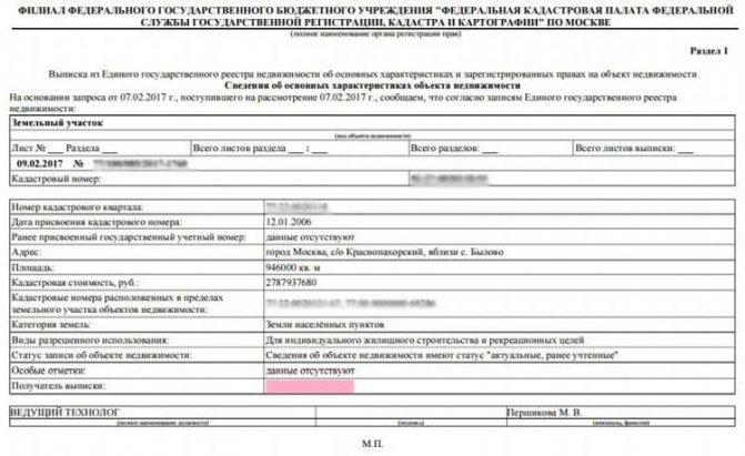
The new sample extract for cadastral registration and state registration contains 4 main sections, each of which has unique characteristics. Section No. 1 indicates basic information on the object of law:
- Personal data of the copyright holder.
- Physical address of the object of right.
- Cadastral number of the object.
- Cadastral assessed value.
- The area of the object of law.
- For buildings - wall material, number of storeys, utilities.
- For land plots - type of land use, category of land.
- There is information about parking spaces (garages and garage cooperatives).
- Date of cadastral registration.
- Year of commissioning of the object of right.
- Information about registration of the USRN extract in Rosreestr, data of the responsible person.
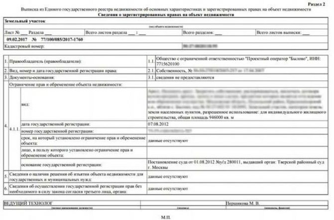
Section No. 2 indicates the legal characteristics. So, here you can see when the object of right received the status and was put on the state cadastral register; this section indicates the data of the copyright holder, cadastral number, as well as information about the encumbrance or restriction, if any.
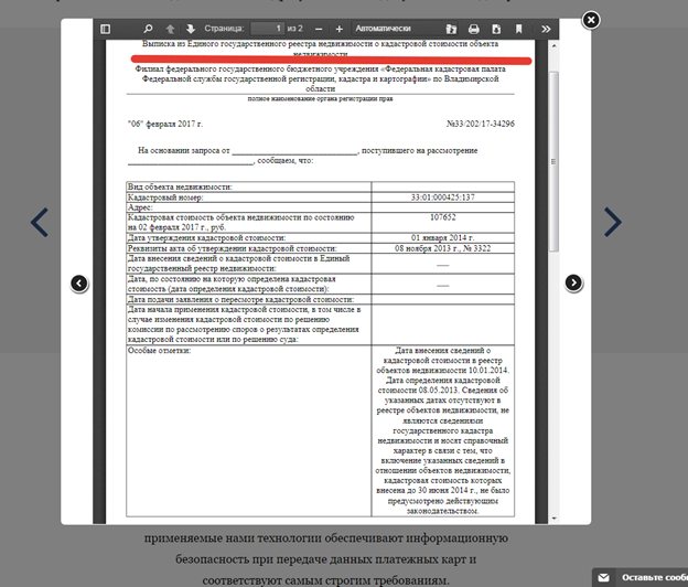
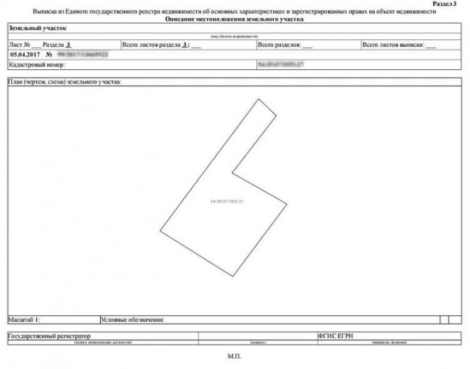
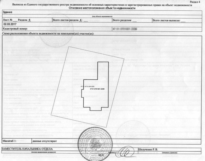
Section No. 3, No. 4, and sometimes also Section No. 5, contain graphic characteristics of the object of law - diagram, drawings, coordinate points of the earth and other characteristics. All information in the cadastral passport is relevant on the day the request is made at the Cadastral Chamber of Russia.
What it looks like: sample and photos of sections
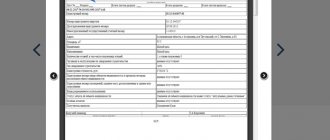
Before the signing of the Federal Law, the cadastral passport for a land plot was provided on three sheets, where the second was mandatory and contained a plan (drawing, diagram).
A sample of what it looked like is shown below.
The document recorded the control points of the site, including those considered controversial (squatting of the plot). The absence of a leaf indicated an unidentified boundary of the plots and often led to disputes.
These extract data contain an expanded information base, and each section of the document indicates clear indicators (examples in the photo).
№1
Provides basic land parcel identification or technical specifications. These include:
- Current and previous number of the cadastre and cadastral quarter;
- Description of location;
- Land category;
- Permitted use;
- Square;
- Cadastral value;
- Information about the rights of current and previous copyright holders;
- Purpose.
№2
Contains information about registered rights . This application provides the full name of the copyright holder(s), type of ownership and document details confirming this fact.
Possible encumbrances are indicated in the current form.
№3
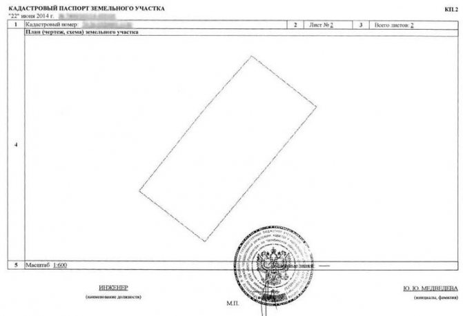
Corresponds to the description of the location of the land plot, including cadastral number and plan.
No. 4 and No. 5
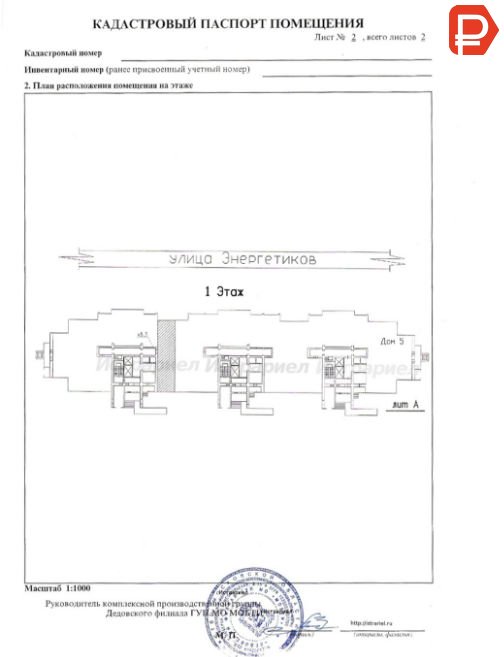
It has a description of the location of the property, including a schematic image of the property, a plan for the location of the premises and a cadastral number.
The authenticity of each sheet is confirmed by a signature, transcript of the signature and the seal of the authorized body.
I put my passport on
The document consisted of 4 parts. paper can be found below.
Video
Materials related to state registration were placed on sheet KP1:
- registration number and date;
- category of land and its area;
- address and purpose of the land plot;
- information about natural objects;
- number of the document on the right to a plot of land, as well as its date;
- cadastral value;
- information about representatives of government agencies who conducted a survey of the territory.
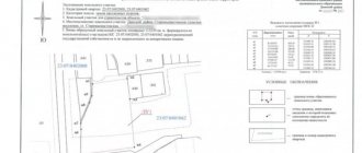
On page KP2 there is a drawing of the territory. Here they are fixed to the boundaries of the land plot. The 2nd form is intended to record encumbrances and restrictions, if present.
The first category includes:
- imposition of easement;
- transfer of real estate for rent;
- seizure of land.
The list of restrictions includes a water protection or sanitary zone. The last column of KP3 bears the name of the organization due to which the encumbrance was imposed. On sheet KP4, information from previous pages is recorded in the form of a drawing. The last two parts of the document are filled out if there is a restriction or encumbrance. If they are missing, only 2 pages are prepared and provided to the customer.
- Form of cadastral passport for a land plot
- Sample cadastral passport for a land plot
From 01/01/17, only an extract from the Unified State Register is provided. It has a number of differences.
- Sample extract from the USRN about a land plot
Nuances when filling out a land document form
Each item on the certificate contains basic information about the allotment.
Filling out sections of the document complies with legal requirements:
- The cadastral number is written after adding a colon, while when filling out old forms a hyphen was used.
- If all the data does not fit on one sheet, numbering is used.
- Indicating the total number of pages of the document is a mandatory requirement.
- The recording of the date of registration of the site with the state is strictly checked.
- A note about previous cadastral numbers must be included in this paper.
- Full verification of the accuracy of the entered data at the location of the object.
- Particular attention is paid to the category of the site and permitted use.
- Surveyors rely on a point with a coordinate system.
- Individual paragraphs disclose information about land surveying, division, merger, creation and liquidation.

In addition, the passport is filled out in a certain order and adheres to the established rules.
The information provided to the state real estate cadastre is identically displayed in the cadastral passport, without any corrections, erasures or errors.
The presence of these deviations gives the right to consider the document invalid .
Based on the results of the owner’s request, the finished version is issued on paper, with fixed data on modern printing technology.
You can obtain a land cadastral passport at the territorial office of Rosreestr, at the MFC (provided that the request was generated in the center) or on a PC via email.
Each section is important and cannot be excluded from the document . All data is necessary when making transactions with the site.
Types of land documents
The cadastral passport used to be the main document that was required when conducting land transactions. Its registration was carried out by the Cadastral Chamber, today its functions have been transferred to the Unified State Register of Real Estate. The document contains unique information related to a specific land area.
It was impossible to do without it when making transactions: buying or selling, donating, inheriting, applying for a loan, when changing borders, as well as in various legal proceedings.
Order of the Ministry of Economic Development No. 504 dated August 25, 2014 (now no longer in force) indicates the main types of cadastral passports and extracts:
- CP of the land plot;
- CV of the land plot;
- Cadastral plan of the territory.
More information about obtaining an extract from the Unified State Register can be found here.
Validity
Legislative acts do not specify the validity period of a passport . The reason for obtaining a new document may be construction work carried out to expand or reduce the boundaries of the property.
Data on objects is updated every five years, and if adjustments are made to the plots, it is necessary to notify the BTI about the planned work, and then apply for a new passport.
The state seeks to reduce the time it takes for the population to obtain the necessary certificates, so the system for obtaining data online will be improved.
Territory passport photos
To find out what a cadastral passport for a land plot is, it is recommended to study its photo. They will give you a better idea of the document.
What does a cadastral passport for a house look like?
The document also includes two sheets that contain basic information about the building, as well as a house layout with coordinates. Very similar to what the document above contains. There are some differences that are inherent in registering a home. We will describe in more detail what a cadastral passport for a house looks like; photos will demonstrate the appearance in more detail.

Cadastral document for a house The first sheet contains information about the type of structure. Naturally, there is also a cadastral number. Information about the purpose of the building is provided, as well as a brief description. Also, in addition to geographic coordinates, there must be a full address.
What a cadastral passport for a house looks like, a photo of the second sheet will help you understand better. This page contains a location diagram according to the electronic map. There are also geographic coordinates that are assigned to the property in question.
Sample cadastral passport for a house