The concept of establishing site boundaries
The establishment of boundaries, carried out in accordance with the requirements of the law, allows you to individualize the site among others, to form it as a full-fledged real estate object. The external boundary of a land plot consists of geographic coordinates determined by geodetic survey of the territory and plotting them on topographic maps and diagrams.
The boundaries of a land plot make it possible to determine its location, that is, to tie it to the boundaries of neighboring formed plots, as well as to natural or artificial objects.
Establishment of site boundaries is required in the following cases:
- 1) Initial formation of a land plot for the purposes of cadastral registration and subsequent provision for use by individuals and legal entities;
- 2) Carrying out complex cadastral work for the purpose of establishing or changing land categories, territorial zoning as part of the preparation of urban planning regulations;
- 3) The presence of a discrepancy between the external boundaries of land plots, one or more of which are at the stage of formation (definition).
The main purpose of establishing boundaries is to individualize a specific land plot, making it possible to distinguish this object from similar ones.
Boundary Establishment Procedure
The procedure for establishing boundaries is part of the unified process of determining the location of a site and is regulated by Federal Law of July 24, 2007 No. 221-FZ “On the State Real Estate Cadastre”.
In the Russian Federation, the activity of establishing boundaries is carried out by cadastral engineers, who are required to have a professional qualification certificate, and also be a member of one of the self-regulatory organizations in the field of cadastral activities.
These works are carried out by cadastral engineers upon request of government bodies and by concluding an agreement with any interested party.
Based on the results of cadastral work, the external boundaries of the land plot are formed, which make it possible to distinguish it from a group of adjacent homogeneous objects. The establishment of boundaries must necessarily be accompanied by reference to the boundaries of neighboring areas.
One of the elements of the concept of establishing boundaries is to clarify the boundaries of the formed land plot. This type of work may be required in the event of a technical error identified by the cadastral registration authorities, which consists of crossing the boundaries of one or more neighboring plots, as well as the overlap of the boundaries of the plot with the boundaries of lands that have previously undergone the registration procedure.
The legislation provides that the establishment of boundaries is within the competence of the bodies of Rosreestr, which carry out cadastral registration of a land plot based on the results of the work of a cadastral engineer. It is the territorial bodies of Rosreestr that enter information about land plots, including established boundaries, into the Unified State Register.
In some cases, the issue of establishing boundaries can be resolved in court. This situation arises in the absence of agreement between the title holders of adjacent plots regarding common external boundaries. The interested party applies to the court with an act of approval of boundaries, which indicates the reasons for the objection regarding the coordinates of the common boundaries of the plots. The cadastral engineer who carried out cadastral work on the disputed site is involved in the legal process.
A court decision to establish boundaries that has entered into legal force will be the basis for the Rosreestr body to enter information into the Unified State Register.
What are the boundaries of a land plot and what are they like?
In the process of forming a land plot as an independent unit for which ownership is available or allocated, one of the main definitions used to distinguish an object from the mass of land is the border of the land plot.
It is understood as a contour line that defines by its outline the ownership of one person or group of persons.
Initially, such a line is located exclusively on paper or electronic media, but subsequently a procedure for allocating a plot is carried out, during which boundaries are established in kind, that is, they are delineated on the ground by a closed line, within which the plot will be contained that belongs to the person under the rights of ownership or use.
What it is?
In accordance with the articles of the Land Code of the Russian Federation, the boundary of a site is understood as a line defining the location of a specific area (unit), which includes all existing subsoil, as well as the soil layer itself.
Thus, this line limits the property rights of a certain individual. or legal persons, simultaneously installing it on all buildings of the territory, as well as natural objects.
The establishment of boundaries is carried out in accordance with the coordinates of the terrain, as well as characteristic points, which are also called turning points.
When determining the boundaries of land plots, a concept such as multi-contour , that is, a single ownership consists of several selected parts that may not even intersect.
At the same time, they represent a single whole, having a gap between themselves, provoked by the passage of other land plots located by natural objects.
Kinds
When considering the concept of cadastral boundaries, in this case, two concepts are actually used that are somewhat different from each other - the cadastral boundary and the actual one.
Cadastral
The concept of a cadastral boundary can be called an official or documentary definition.
That is, this is the line that runs between the coordinates of the points determined by the cadastral engineer when drawing up the boundary plan.
In turn, the cadastral boundary is divided into two separate definitions - declared and geodetic .
Geodesics contain exact coordinates and geodetic points.
Actual boundaries mean those lines that are drawn directly at the location of the plots.
Boundaries are drawn onto the area during the process of drawing up a boundary plan, when a cadastral engineer goes to the area and, after carrying out the approval procedure, establishes the turning points of the plot.
Subsequently, a line drawn between them forms a closed-type contour , which will act as the actual border.
Requirements for boundaries
In the process of forming a boundary and establishing turning or characteristic points, the cadastral engineer must take into account the requirements that it must meet.
So, you will need to follow the following rules :
- The boundaries of the allotment should not intersect with any territorial boundaries of municipal settlements or settlements;
- The contour of the plot (border of the allotment) should be as simple . That is, the ideal shape is a quadrilateral. Of course, due to natural characteristics, configurations of neighboring areas and other factors, it is not always possible to achieve minimal fracture;
- The contour of the site should not intersect adjacent plots . In such a situation, one section will overlap another (partially or even completely);
- The boundaries must be determined in such a way that the site has access to the roadway and all communications passing in the area are accessible to it.
What to do if boundaries are not set?
The absence of established boundaries for a land plot imposes a lot of restrictions on actions with it . If it is necessary to determine it, the owner or other interested party must perform a number of actions in accordance with the established procedure of the Land Code of the Russian Federation and the Federal Law regulating cadastral activities.
Engineer invitation
In fact, inviting an engineer becomes the initial stage of the land surveying process, when the owner of the plot enters into an agreement to determine the boundaries of the plot.
When choosing a geodetic organization, you must pay special attention to ensuring that the engineer performing the work has permission (license) for this type of activity , otherwise the drawn up plan will not have legal force.
Coordination with neighbors
An obligatory stage in the formation of boundaries is the moment of agreement on the passing boundary with interested parties - the neighbors of the plot, whose plots are directly in contact with the one of interest along the dividing line.
All owners of adjacent plots are notified in advance by personally delivering a notice, sending a document by email or Russian post, or publishing an advertisement in a local newspaper.
Everyone appears at the appointed time at the location of the land plot and gets acquainted with information regarding the passage of the boundary. If there are no objections, the neighbors sign as a sign of consent and the boundary is considered possible for display and display on the site.
Measurement and determination of coordinates
When determining the boundaries of an allotment, an equally important procedure is the engineer’s visit to the area to determine the establishment of turning points and the passage of boundaries. This procedure is necessary in order to take into account all the features of the terrain , as well as the actual location of neighboring areas.
Appeal to the territorial chamber
After the boundaries are established and the boundary plan is officially drawn up, the owner of the plot has the opportunity to contact the cadastral chamber. Such an appeal is carried out for the purpose of entering data on the allotment into a unified state register .
In parallel with this action, the owner has the opportunity to obtain a cadastral passport, on the basis of which it is possible to obtain ownership rights.
With what accuracy are they determined?
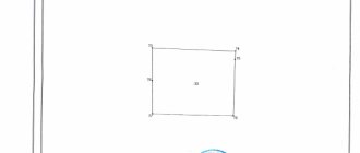
In the process of defining boundaries and placing them on the ground, turning points are established, between which contour lines are drawn.
Due to various factors such as engineer errors, weather conditions, erroneous information, outdated or uncorrected equipment, the accuracy of the boundaries may not be complete.
In such a situation, the law establishes certain standards that contain data on permissible errors in establishing site boundaries.
the following indicators should be established :
- For those areas that are located in the zone of a populated area - 10 cm;
- For plots intended for a summer house, home, garden, vegetable garden, etc. – 20 cm;
- For agricultural plots, this error can be greater and amount to up to 2.5 meters.
Where can I find out the boundaries of the allotment?
Many plot owners often wonder how they can obtain information regarding the boundaries of a land plot.
This information may become available after you complete the following steps :
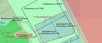
- Obtain information on the Rosreestr website. To do this, you need to go to the portal and enter the cadastral number of the plot. The window that opens will contain all the necessary information on it, as well as data on the boundaries of the site;
- Contact the Rosreestr branch . To do this, you will need to send an official request and wait for the result. Due to the fact that this method takes quite a long time to provide information, it is no longer used so often;
- Obtaining information from cadastral documentation for the site. If you have such papers in your hands, it is enough to open the boundary plan or cadastral passport and get all the data regarding the boundaries.
An adjacent property line is a line that is superimposed over the actual property line where lot lines follow the boundary of an adjacent property. Unlike the main boundary of the site, which is built along characteristic points, such lines are determined by the interval of overlap with the adjacent land plot .
The border of the adjacent plot on the plan is displayed outside (behind the main line) and before being displayed also requires prior approval with the direct owner of the adjacent plot .
What to do in case of intersection?
The intersection of plot boundaries means their displacement in any direction, while the boundaries of the plot directly intersect .
Such cases may occur when errors occur in drawing up a boundary plan for one of the neighboring areas, or both at the same time.
In addition, such cases arise when the territory is squatted, unauthorized movement and displacement of the boundaries of the site under the influence of third-party factors.
If such errors are detected, the site owner must perform the following actions :
- Contact Rosreestr with an application to clarify the boundaries (if such a situation occurs after entering information on both sections into Rosreestr);
- Agree on the location of the boundaries of the site, if such a situation arose during the formation of the boundary plan. In this case, a similar action can be performed by a cadastral engineer;
- If it is impossible to solve the problem of crossing boundaries peacefully, file a claim in court to establish the actual boundaries and eliminate all inaccuracies or consequences of illegal actions of land owners.
Conclusion
So, when determining the boundaries of a site, an extensive list of work is carried out, during which errors may be made.
To prevent any factors - a large degree of brokenness of the site, intersection of boundaries of neighboring sites, incorrect calculation of turning points, you should contact only qualified specialists with experience in such work to draw up boundary plans.
Results of work to establish the boundaries of the land plot
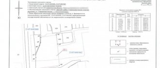
After completing cadastral work to establish the coordinates of the boundaries, the formed plot of land must undergo the procedure of registration with the state cadastral register. Such accounting is carried out on the basis of documents prepared by an engineer based on the results of land cadastral work, the main one of which is the boundary plan.
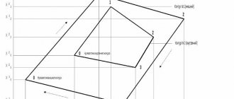
A boundary plan is a text document that describes the main characteristics of a land plot, as well as a topographic map (diagram) on which the coordinates of the boundaries of the land plot and their intersection with adjacent objects are recorded.
After completing the cadastral registration procedure, the land plot is assigned a unique identification number, and information about it is entered into the Unified State Register of Rights to Real Estate and Transactions with It (USRE). If a cadastral engineer clarified the boundaries of a previously formed plot, then changes are made to the Unified State Register of Rights to the coordinates of the boundaries of the land plot.
After completing the work to establish the location of the land plot and registering it with the cadastral register, this plot can act as the object of various types of transactions, i.e. is considered entered into economic circulation.
Author of the article
What are contiguous land plots and what are the features of their association and establishment of boundaries?
Article 22. Requirements for the boundary plan
1. A boundary plan is a document that is drawn up on the basis of a cadastral plan of the relevant territory or an extract from the Unified State Register of Real Estate about the corresponding land plot and in which certain information entered in the Unified State Register of Real Estate is reproduced and information about the land plot or land being formed is indicated plots, or about a part or parts of a land plot, or new information about a land plot or land plots necessary for entering into the Unified State Register of Real Estate. (Part as amended, entered into force on January 1, 2021 by Federal Law of July 3, 2021 N 361-FZ.
2. The boundary plan indicates:
1) information about the land plot or land plots being formed in the case of cadastral work, which results in the preparation of documents for submission to the rights registration authority of an application for state cadastral registration of the land plot or land plots;
2) information about a part or parts of a land plot in the case of cadastral work, which results in the preparation of documents for submission to the registration authority of rights of an application for state cadastral registration of a part or parts of a land plot;
3) new information about a land plot or land plots necessary for entering into the Unified State Register of Real Estate in the case of cadastral work, which results in the preparation of documents for submission to the rights registration authority of an application for state cadastral registration of a land plot or land plots.
3. If, in accordance with federal law, the location of the boundaries of land plots is subject to mandatory approval, the boundary plan must contain information about such approval.
4. Part lost force from January 1, 2021 - Federal Law of July 3, 2021 N 361-FZ..
5. The boundary plan consists of graphic and text parts.
6. The graphic part of the boundary plan reproduces information from the cadastral plan of the corresponding territory or an extract from the Unified State Register of Real Estate about the corresponding land plot, and also indicates the location of the boundaries of the land plot or land plots being formed, or the boundaries of a part or parts of the land plot, or the specified boundaries of land plots , access to newly created or modified land plots (passage or passage from public land plots), including through the establishment of an easement. (Part as amended, entered into force on January 1, 2021 by Federal Law of July 3, 2021 N 361-FZ.
7. The text part of the boundary plan shall indicate information about the land plot or land plots necessary for entering into the Unified State Register of Real Estate, including information about the geodetic basis used in the preparation of the boundary plan, including points of state geodetic networks or reference boundary networks, as well as in the case established by part 3 of this article, information on the approval of the location of the boundaries of land plots in the form of an act of agreement on the location of such boundaries.
8. The location of the boundaries of the land plot is established by determining the coordinates of the characteristic points of such boundaries, that is, the points of change in the description of the boundaries of the land plot and dividing them into parts.
9. The area of a land plot, determined taking into account the requirements established in accordance with this Federal Law, is the area of a geometric figure formed by the projection of the boundaries of the land plot onto a horizontal plane.
10. When clarifying the boundaries of a land plot, their location is determined based on the information contained in the document confirming the right to the land plot, or in the absence of such a document, based on the information contained in the documents that determined the location of the boundaries of the land plot when it was formed. If there is no information in the documents about the location of the boundaries of a land plot, its boundaries are considered to be boundaries that have existed on the ground for fifteen years or more and are fixed using natural objects or objects of artificial origin that make it possible to determine the location of the boundaries of the land plot. (Part as amended, entered into force on September 16, 2021 by Federal Law of June 17, 2021 N 150-FZ.
11. The boundaries of a land plot should not cross the boundaries of a municipal entity, except if an error reproduced in the Unified State Register of Real Estate is identified in determining the location of the boundaries of such a municipal entity in the document on the basis of which information was entered into the Unified State Register of Real Estate. The boundaries of the land plot should also not cross the boundaries of a populated area, except if an error reproduced in the Unified State Register of Real Estate is identified in determining the location of the boundaries of such a populated area in the document on the basis of which information was entered into the Unified State Register of Real Estate. The boundaries of the land plot should also not cross the boundaries of territorial zones, forestries, except in the case of the formation of a land plot for carrying out work on geological exploration of the subsoil, development of mineral deposits, placement of linear objects, hydraulic structures, as well as placement of reservoirs and other artificial water bodies, in the case , provided for in Article 60_2 of this Federal Law, or the case of identifying an error reproduced in the Unified State Register of Real Estate in determining the location of the boundaries of the territorial zone. At the same time, the intersection of the boundaries of a land plot with the boundaries of municipalities, settlements, territorial zones, forestries is understood as: (Paragraph as amended, put into effect on August 11, 2017 by Federal Law of July 29, 2021 N 280 - Federal Law; as amended, introduced into force from July 1, 2021 by Federal Law of December 27, 2021 N 538-FZ.
1) the presence of a common point or points of the boundaries of the land plot and the boundaries of the municipality, settlement, territorial zone, forestry, which are formed as a result of the location of one or more characteristic points of the boundaries of the land plot outside the range of the mean square error in determining the characteristic points of the boundaries of the municipality, populated point, territorial zone, forestry; (Clause as amended, entered into force on July 1, 2021 by Federal Law of December 27, 2021 N 538-FZ.
2) the location of at least one of the contours of the boundaries of a multi-contour land plot outside the boundaries of the corresponding municipality and (or) settlement or territorial zone.
12. The boundary plan is prepared in the form of an electronic document and signed with an enhanced qualified electronic signature of the cadastral engineer who prepared such a plan. The boundary plan, if provided for in the contract, is also prepared in the form of a paper document, certified by the signature and seal of the cadastral engineer who prepared such a plan, for transfer to the customer under the contract.
13. The form and composition of information on the boundary plan, requirements for its preparation, as well as requirements for accuracy and methods for determining the coordinates of characteristic points of the boundaries of a land plot are established by the regulatory body.