
The legal capacity of land owners depends on the results of boundary surveying with land plots located in the neighborhood .
It is also very important for owners of neighboring plots to clearly define and secure boundaries.
Therefore, their presence during land surveying and their expression of their opinions are an important condition for the correct and legal conduct of the land surveying procedure.
When approval is needed
One of the stages of the process of land surveying is the coordination of its boundaries with adjacent landowners. This is the most difficult moment, which causes many conflicts and litigation.
Let's look at how to properly survey a plot of land with neighbors and what documents will be required from them.
Agreeing on the location of boundaries is required if the neighboring area :
- relates to the personal property of its owner;
- belongs by right of lifelong inheritable ownership;
- is in constant perpetual use;
- leased from the state or municipality.
This is regulated by Part 3 of Article 39 of Federal Law No. 221 “On the State Real Estate Cadastre”. A neighbor participating in the determination of boundaries has the right to raise objections only along his own border.
Obtaining approval occurs only free of charge .
Coordination of boundaries when surveying a land plot
Is the consent of neighbors required for land surveying? (You will find a sample act with signatures below)
According to Federal Law of the Russian Federation No. 221, coordination when delineating the boundaries of land plots is a mandatory procedure!
This regulatory act states that when clarifying the location of a plot, consent is required to survey the land plot of the owners of adjacent territories, if the survey affects boundaries, cadastral information about which has already been previously entered into the state real estate register (about what surveying and cadastre are and what they have in common, read here, and from this article you will learn how to find out whether a land plot has been surveyed or not).
In other words, when surveying a land plot, the consent of neighbors is necessary when the location of the boundary of the plot of the interested party, which is also the boundary of the land allotment of a second person, is clarified (how is land surveying done?)
When choosing a specific land surveying project, the customer may prefer demarcation on the ground or solely on paper (read about what a territory planning and land surveying project is and how to prepare it here). This is necessary to know, since often contractors, taking advantage of the customers’ ignorance, keep silent about this, deliberately increasing the volume of contract work.
The right to consent to clarify the boundaries of land plots has:
- Owners of plots . An exception is made for owners whose ownership municipal or state land was transferred for indefinite use, as well as legal entities (not municipal enterprises).
- Citizens who received land on the basis of lifelong inheritable ownership.
- Tenants who have signed an agreement for the use of land in state or municipal ownership for a period of five years or more.
The interests of owners can be protected by their representatives acting on the basis of a notarized power of attorney.
IMPORTANT! Consent is not required if information about the owners of adjacent territories is available to a limited circle of people (is not publicly available), as well as in cases where establishing boundaries on the area is impractical or, moreover, impossible.
Thus, without consent to land surveying from neighbors, the procedure can be carried out in the following cases:
- forest areas;
- territories close to state borders and other protected lands;
- agricultural lands of the indigenous population in the Far Eastern District, the North and Siberia;
- disputed boundaries previously defined by the boundaries of adjacent linear objects (read about how to resolve a dispute with neighbors about land surveying and the imposition of boundaries here).
Notification of neighboring property owners

Once the approximate day for the survey has been set, it is required to notify all owners of land plots bordering the given one .
The law sets a time limit for notification: it must be sent no later than 30 days before the expected day of approval.
You can notify your neighbors in several alternative ways:
- Notify by registered letters with notifications . The places of residence of neighbors can be found out in the cadastral service. It is advisable to use this type of notification when there is confidence that the citizen will not sign the notice, and therefore the act of approval. Therefore, it is advisable to send three letters to the neighbor, since a letter sent three times in the name of one person becomes a basis for believing that the signature of this person received.
- Personally deliver the notices to each of the recipients, receiving his signature. If there is no signature, it will be impossible to prove that the neighbor was not served with a notice.
- Send an email (with a read receipt). This type of notification is the least popular, since not everyone has an email and email addresses are not publicly available.
- Publish an ad in the local press . This is usually practiced if the place of residence of a neighbor cannot be determined, or when delineating plots located within a gardening and dacha partnership.
A notice sent to a neighbor can be written in free form (a sample can be viewed and downloaded via the link), but it must include the following information :
- The notification begins with an address to this specific citizen indicating his full name.
- Next, enter the full name of the person requesting the procedure, his address and telephone number for contacts.
- The data of the cadastral engineer, his full name, address, telephone number are recorded.
- The address of the actual location of the site and its cadastral data are indicated. If there is no address yet, the block where the site is located is indicated.
Information about adjacent areas is included, with addresses and exact numbers. At the end, the time and place of the planned coordination and ways to obtain information about the procedure being carried out are indicated.
Step-by-step instructions for coordinating storage boundaries
When drawing up a plan for boundary work, it is necessary to notify the owners of border land plots. The notification must be given no later than 30 days before a general meeting of owners of neighboring land plots is scheduled.
Principles and procedures for notification
According to the charter, the following forms of notification about the approval of land boundaries are allowed:
- Personally signed by neighbors;
- By email in the form of a letter;
- By registered mail;
- Publication in the mass media system.
In the first and second variants, the notification rules are suitable if the neighbors definitely come and certify the document and put their own signature on the notification about the determination of land boundaries or can respond by email. This, in turn, will be an argument for conscientious notification of neighbors.
Using a registered letter, you can notify neighbors whose location has been established, but they react unkindly to the planned operation. If, after being notified three times, the neighbors do not give an answer and ignore the notifications, not coming to the meeting regarding the delimitation of boundaries, then documentation from the postal operator will be attached to the document indicating that the letters were actually sent 3 times. The document must have a signature and seal.
Neighbors whose location is unknown are notified through the media - announcements about the gathering of owners indicating the address location of the site. 30 days after the publication in the media, a meeting can be held.
Where to go?
When all neighboring owners have received notification of the planned operation, it is necessary to submit an application to the surveying company where the land plot is located. The application must be submitted to a cadastral specialist who is authorized to carry out the data src=»https://seismofond.ru/wp-content/uploads/2018/06/1508056150_00.jpg» class=»aligncenter» width=»450″ height=»394 ″[/img]
During the month, the cadastral engineer carries out the following work:
- Preparation of a preliminary site plan;
- Topographic measurements;
- Prepares the final outline of the land boundaries;
- Prepares the preparation of documents on the coordinates of turning points;
- Installs temporary border signs.
On the day of the meeting, the cadastral specialist must personally attend the meeting and, obviously, show the assembled owners the boundary line between the plots.
If the boundaries are drawn not in accordance with the principles or with errors, then you need to contact the geodetic company again.
Provision of documents
When submitting an application you must submit:
- Title document.
- Certificate of ownership of the land plot.
During the meeting, the owners of neighboring plots are required to come up with a passport and a certificate of ownership, from which the cadastral engineer will extract the details and add them to the approval document.
It is allowed to have representatives who carry out trust management on the basis of a notarized power of attorney.
Service price
As a rule, geodetic companies do not charge fees for approval, but use the traditional price range, expressed in a certain fixed amount of 5-7 thousand rubles. The survey price depends on:
- The locality where the entire procedure is carried out;
- Company status;
- Categories of land plots;
- Area of plots.
The indicated price applies to rectangular plots of 6-8 acres in size, which are provided for summer cottages or land in populated areas.
If the shape of the site is complex, the calculation will be carried out based on the number of turning points. In this option, prices for services can be determined in aggregate.
Elite plots in the Moscow region or in the suburbs of St. Petersburg are serviced according to different calculations. Typically, the minimum price for work in such areas will be about 25-30 thousand rubles.

Deadlines
Taking into account the norms that provide for notifying neighbors 30 days before signing the act, the procedure for agreeing on the location of land boundaries does not take less than 30 days, but can usually reach 1.5 months. If a company has a lot of clients in the queue, the execution of the service may be delayed.
How does the procedure work?
The law allows for approval to be carried out separately with each of the owners or joint approval by convening a meeting of neighbors.
The collective method is more preferable, since it is possible to jointly review previously prepared cadastral and boundary plans, evaluate the boundaries and discuss them.
All explanations are made by the cadastral specialist, who also fills out the approval document, which must be signed by all participants.
The specialist must:
- Personally check the passports of those present, and, if necessary, verify the presence of a notarized power of attorney.
- Provide all interested parties with documents, diagrams and plans, and explain the details.
- Show the location of plot boundaries on the ground.
If the prepared documents do not raise any objections or complaints, then the approval is considered received and an act of approval of the boundaries of the land plot is drawn up.
Act
The act of approval is an important document; it is the key evidence when considering controversial housing issues in court. It is drawn up by a cadastral worker with the signature of all persons participating in the land survey (owners of all plots whose boundaries are the subject of clarification).
It is the engineer who is responsible for the compliance of the persons signing the document! Its tasks include checking the passports of all land survey participants, and if their representatives are present, notarized powers of attorney to protect the interests of land owners.
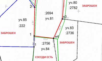
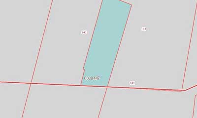
In addition to the passport data of the owners, the act contains cadastral information about the plots (address, area, etc.) and their drawing with the boundaries determined during the approval process.
If all owners of the affected areas were present when drawing up the document, then the act is considered completed.
Signing of the final act
An act of approval is a document by signing which all adjacent land users express their agreement or disagreement with the establishment of boundaries .
Boundaries are considered as agreed upon if the act is certified by the personal signatures of all landowners, and in the absence of owners there are objections written by them.
Acts are drawn up according to established rules , violation of which makes the document invalid:
- The act is signed by all owners of adjacent plots or their legal representatives.
- All information entered in the act must be truthful and correspond to the data from the cadastral plan and other documents.
- If disagreements arise during the discussion, they are documented in writing in a separate document and filed with the act.
Any disagreements that arise are resolved according to the terms of the Land Code of the Russian Federation . If this is not possible, the situation will need to be resolved through the courts.
The act indicates the full names of all adjacent landowners, their opinions on the boundaries of the site, and also inserts diagrams and drawings of the sites.
How to get it?
Territory approval is carried out in the personal presence of the owners of adjacent plots or their legal representatives. Here is the procedure for agreeing on the boundaries of a land plot during land surveying.
- The procedure begins with an application to a cadastral engineer and the subsequent conclusion of an agreement, after which he draws up an act, which is the basis for registering the plot of land in the cadastral register.
- All interested parties must be notified in advance about the implementation of the procedure for approving land boundaries .
This is done in writing, for example, a registered letter is sent by mail to the neighbors. This is done so that later they cannot justify their absence by the fact that they were not warned in a timely manner. - If any of the persons interested in land surveying does not appear for the procedure, having been notified in the prescribed manner, there is no need to refuse land surveying.
In the absence of the land owner, as well as his written objections regarding the land survey, this fact should be noted in the approval act, and the land survey plan should be supported by documents confirming the timely notification of the citizen about the date of the procedure (about why a land survey plan is needed and where to get it , read here). - If the owner of the plot is unknown, then the established form of notification is the publication of a corresponding announcement in one of the regional media. If there is no response within 30 days, the approval is considered completed by default.
IMPORTANT! There may be cases when the land on the territory of which the disputed border is located is registered with the bank as collateral. How to be in this case? Is it necessary, in addition to the owners’ consent to survey, to also obtain the bank’s consent to survey the land? The answer is clear: no.
You can find a sample of the bank's consent to survey a land plot here.
According to Article 39 of the Cadastre Law, the following have the right to approval:
- owners.
- Permanent (perpetual) owners (not state or municipal).
- Owners by right of inheritable ownership.
In other words, there are no mortgagees on this list, and accordingly, their consent to the procedure for land surveying is not required (read about what land surveying is and why it is needed here, and from this article you will learn why land surveying is done and what is needed to carry out this procedure).
If the neighbor’s reluctance to participate in the agreement is expressed in writing, and his refusal is convincingly justified, then the location of the disputed boundaries will be further determined by the land owners in court.
Clarification of boundaries without the consent of neighbors
Many people are interested in the question: is it necessary to have the consent of neighbors when carrying out land surveying of their property? The law provides for cases when it is possible to carry out approvals without involving neighbors.
Such cases include:
- All adjacent landowners have already carried out land surveying of their plots , the boundaries have been documented and in fact, the interests of the customer of these cadastral works have not been affected. The cadastral engineer must obtain all the data on these plots and note this in his documents. The plot is simply “tied” to the already registered boundaries of adjacent plots.
- It is impossible to establish the exact place of residence of the neighbor , the site has long been abandoned, no one is looking after it, his address and contact details are unknown to anyone. In such cases, advertisements are published in newspapers. If the owner of the site does not make himself known within a month, the approval is considered to be carried out by default.
- The owner does not appear at the appointed time , despite the fact that he was notified by letter or in person. There were no written objections or justifications for his reluctance to participate. Therefore, the approval is considered as received, the corresponding entry is entered into the act, and the boundary plan is supplemented with the necessary documents.

Please keep in mind for the future that if this neighbor provides evidence that his failure to appear is valid (illness, missed notice, stay abroad), he has the right to seek a review of the approved boundaries through the court.
When a written refusal indicating the grounds for absence is received within a month after notification , this document is also filed with the approval act, and a special note about this is made in the text.
Objections do not prevent full use of the site , but future disputes are possible, and the buyer will need to be notified of this upon sale.
Sample consent of neighbors for land surveying
If the parties fail to appear at the meeting after their written notification and notice in the newspaper (or failure to provide a reasoned refusal to participate), the boundaries are agreed upon without them (one month after publication in the newspaper), the refusal/absence is recorded in the Act, and the boundaries are considered established.
It is extremely important that the party-participant signs that he has received this letter. If it is impossible to establish the whereabouts of the participating party (he has left, disappeared, there is no information, etc.), notification is carried out through publication in a municipal newspaper.
When is it possible to set boundaries without agreement?
If the boundaries of the site do not pass through the sites included in the Unified State Register of Real Estate, they are not required to be approved by law.
It is necessary to coordinate only those areas that simultaneously serve as boundaries between neighboring areas (Article 39 of Federal Law No. 221 “On Cadastral Activities” as amended on July 3, 2016). That is, if the site borders on vacant land or faces the street, there is no need for approval.
No approvals are required if this land plot is adjacent to :
- forest area;
- a specially protected area (for example, the borders of a country);
- agricultural lands in the Far North, Far East and Siberia;
Is official consent of neighbors required when carrying out land surveying?
Yes, consent is required. As our legislation states:
- the procedure is carried out in the obligatory presence of persons interested in this issue, which include adjacent land users (owners of plots with which there are no adjacent boundaries are not classified as such), that is, they must be present at the time of geodetic measurements;
- if the procedure for notifying neighbors was followed and if no objections were received from them, the cadastre service registers the approved boundaries according to the boundary plan;
- in the absence of an act of approval or the absence of signatures of all adjacent land users on it, the registering authority has the right to refuse registration of the site;
- if adjacent neighbors were not on site at hour X or simply refused to sign the agreement, the land survey is not canceled, but occurs, only equal to the preliminary one;
- within 30 days from the date of land surveying, absent neighbors have the right to express their disagreement with the results and send justified claims to the appropriate authority.
The approval act must contain:
- personal data of interested parties;
- number and series of identification documents;
- diagrams of points indicating boundaries;
- disagreement and claims of participants (if any);
- signatures of all those present;
- all this must be certified with a signature and an engineer’s seal.
Cadastral errors
When establishing the boundaries of a plot, errors occur, most of which fall under the responsibility of the cadastral specialist . It is he who is responsible for the correctness and legality of the procedure.
The most common mistakes when surveying:
- Carrying out cadastral work led to a violation of the rights and interests of the owners of other plots, namely, a certain part of their territory was seized.
- The agreement was not carried out or was carried out in violation of the laws. For example, neighbors were notified late or were given incorrect information.
- The act was drawn up in violation of the law and contains errors . For example, the required signatures do not belong to the real owners of the plots or their signatures are forged.
Strict sanctions apply to the cadastral engineer . For example, repeated violations lead to the fact that he is deprived of his license and the right to work in this field.
What is it and when is it signed?
Coordination of the extreme boundary of the site is considered an element of land surveying, which determines the right and regulations for the use of the owners’ border areas. It is considered the result of boundary actions. In other words, this is a coordination of the location of the land with neighboring lands, taking into account the documents and not to the detriment of any of the land owners.
To carry out this procedure for establishing boundaries, you must contact the cadastral authorities. They carry out the official establishment of the actual boundaries of the site. An indispensable requirement for determining boundaries is imposed for the following types of land:
- To areas included in the cadastral register.
- On the lands where the work of cadastral specialists is carried out.
- In areas where there is a need to establish actual boundaries.
The approval process certifies the implementation of cadastral work and confirmation from the owners of adjacent land plots in the form of consent signatures in the document. After the boundaries have been detailed, the document drawn up by the cadastral specialist will already have legal force, as well as the definition of legal standards.
What to do if your neighbor does not agree to land surveying
There may be several options for resolving the issue.
There is a certain procedure for approving land surveying:
- All participants in the procedure are warned about the event one month in advance. The warning must be handed in against signature, so that later the other party cannot plead ignorance. If there are assumptions that the owner of the adjacent plot will refuse to sign the deed or may ignore this event altogether, a notification must be sent by registered mail with a list of enclosed documents and return receipt requested.
- If there is no response to the notification received, it is sent again by registered mail 3 times every 2 weeks.
- If a claim is received in response to the letter, it will have to be considered in the district court.
- A preliminary approval act is being prepared.
- After determining the boundaries, the engineer collects the consent signatures of interested parties or issues a waiver of consent to the preliminary boundaries with an explanation of the reasons.
- If interested parties did not come to the meeting of owners of neighboring plots and, accordingly, did not sign the act, land surveying is carried out on the basis of the attached notification of delivery. If no claims are received within a month, the boundaries are considered agreed upon. If, after some time, they go to court, protesting against the survey carried out on the basis of absence from the meeting, the defendant will have in hand all the documents indicating that all measures for informing were taken.
In this case, all issues will have to be resolved through the court. If your neighbor does not sign the agreement, and you have a notice of receipt of a warning about the upcoming event, then you have complied with all legal requirements. The court decides the legality of the land claims of both parties.
Perhaps due to some extenuating circumstances. In this case, land surveying is carried out without his consent. Then you will need to provide the coordinates of the turning points for review, so that he can see the correctness of their location, and ask him to sign the document.