Turning points of land boundaries: what are they and why are they needed?
Each plot has an appropriate configuration, which is delineated on the cadastral plan with a special line, in accordance with established standards.
Paying attention to the shape of the area of the plot, you will notice that the line in certain places rotates 90 degrees if the plot has a square or rectangular shape. In other cases, it bends only slightly, or creates sharp and obtuse angles.
Any cessation of the direct movement of the line is fixed by a point from which it, to one degree or another, deviates from the previous movement and changes it.
If we remember that a cadastral plan is a schematic representation of an actual plot of land , then we can imagine that such points are located in nature - along the boundary line. These are called turning points.
Characteristic points of the boundaries of a land plot are the places where boundary signs are installed and by which the coordinates of the boundaries of the land plot are determined.
According to their location , officially recorded in the survey file and submitted in the form of a cadastral engineer’s report to the State Real Estate Cadastre (GKN), the following is determined :
- The location of the storage facility on the ground, distinguishing it from other areas.
- The person who officially owns a particular plot of land.
Boundary signs installed at turning points must not be arbitrarily removed or changed in their location, which is protected by law.
What is it and why is it needed
If you have the coordinates of the PT, you can establish reliable boundaries, which will be determined with the minimum error permissible when preparing cadastral documentation and carrying out a number of works regarding the sites. In fact, the PT designates with its coordinates the place where the drawn boundary of the section loses the properties of a straight line and bends.
To maintain accuracy and eliminate errors, the boundaries of areas are displayed exclusively using straight lines. At the place where one line stops and, due to the nature of the terrain or the characteristics of the plot itself, the second begins.
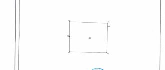
Example PT
By sequentially connecting such points, a closed loop is formed that limits the property limit of the person who has the right to own the site. By applying and taking into account the PT, the following cadastral works and actions related to plots are carried out:
- establishing the boundaries of the land plot ОPrav _ 169-170;
- identification of errors that resulted in the intersection and displacement of the boundaries of ОPrav _ 171;
- removal of site boundaries ОPrav _ 167;
- clarification of the boundaries of the site ОPrav _ 174.
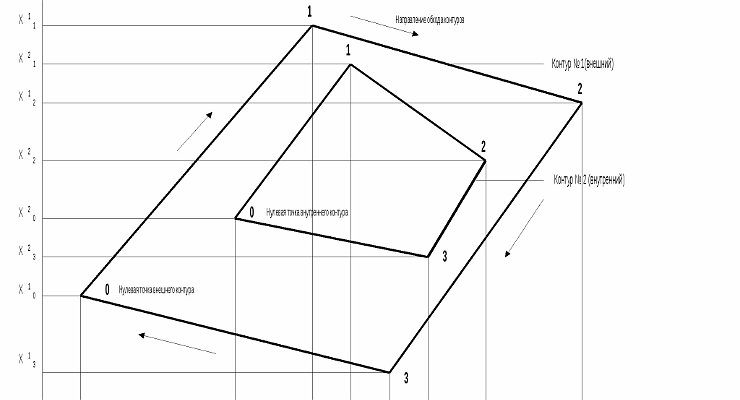
The minimum value for the number of PTs of the section will be four - this way the plot will look perfectly flat with the complete absence of bends and numerous turns.
Such forms are a priority when setting boundaries, but in practice, due to clarifications and the need to place points with reference to the terrain, as well as subsequent adjustments, this ideal form may undergo some changes.
Such changes lead to curvature of the boundaries of the sections and the need to establish the coordinates of additional points, which simultaneously become the end of some straight lines and the beginning of others.
PT designations are entered into the relevant cadastre records and can be in the following forms:
- on electronic media;
- on paper;
- in topographic form.
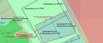
Layout of PT boundaries of the site
In practice, areas with a significant number of PT are in most cases located in areas where there is a complex topographic pattern and the placement of additional ones (except for the minimum permissible value of 4 units) is necessary.
On the other hand, additional PTs caused by necessity sometimes, on the contrary, lead to the presence of errors in the laid boundaries - if even the slightest error is made regarding just one point of the plot, part of the entire plot can significantly shift to the side.
Such minor inaccuracies sometimes even lead to such incidents that as a result of drawing lines along the coordinates of the PT, one section actually overlaps the adjacent one.
What are the coordinates of the memory boundaries?
The provisions of the Federal Law on State Property Committees dated July 24, 2007 No. 221-FZ require entering information about all land plots and their legal owners into a single register where they are stored:
- on paper in text form;
- on paper in a topographic version;
- in electronic format in both versions.
Each of the documents requires the allocation of plots according to their properties, the main of which are the coordinates of characteristic points of the boundaries of the land plot . Without information about the coordinates of the boundaries, it is unacceptable to actually fix the location of the plot.
Material about the passage of borders is prepared by a cadastral engineer during land surveying . If you don't know what it is yet, then this article has a definition. He takes them out into nature or checks the accuracy of their passage, after which he draws up a boundary plan, with a drawn line on the appropriate scale and indicating the coordinates of the points of the boundaries of the land plot.
Detailed land surveying instructions can be found in our other article. It will also be useful for the owner to know what documents are needed for land surveying.
The location of boundary boundaries is certified by an act of agreement on their location with neighbors on the site.
The act of agreeing on the boundaries of the allotment with neighbors: form, example of filling.
On the ground, boundary boundaries between neighboring plots must be in strict accordance with the cadastral plan.
Mostly, land disputes with neighbors and subsequent problems of the copyright holder are associated precisely with the incorrect determination of the coordinates of the boundaries of land plots. Therefore, when ordering geodetic work, the owner should choose a company that provides boundary measurements with high-precision satellite equipment.
Border coordinates
Considering the concept of coordinates of the boundaries of an allotment, in parallel with this definition, the almost identical “coordinates of boundaries” is used. In accordance with the Federal Law regulating state cadastral activities, any allocated plot is subject to entering data about itself into a single state. registry.
Each of the document forms in which such information is provided may look slightly different, but they all contain data on boundary coordinates .
That is, such plans reflect those characteristic features of information that distinguish them from any other plot anywhere in the world and, in fact, make it possible to determine its location for the direct assignment of property rights.
In fact, the coordinates of the boundaries cannot be established (from a mathematical point of view), since the location and direction of the boundaries of the site are determined by single points, the coordinates of which become the so-called indicator of where the boundary will lie.
Thus, when using the concept of “boundary coordinates,” you should understand that you automatically mean the coordinates of turning or characteristic points.
In addition to the direct coordinates of the turning points of the site, according to the current legislation, when drawing boundaries in nature, additional designations , which are installed on a straight line connecting the characteristic points of the plot.
This requirement exists due to a certain length of straight lines, when due to external factors it can be repeatedly broken.
Such additional designations are placed in the range from 1 to 200 meters , that is, at least every 200 meters a boundary mark must be installed, but at the same time it cannot be located more often than every 1 meter.
Installation of additional designations is also carried out by the cadastral engineer after the approval procedure has been carried out with all interested parties and they have signed the relevant act.
Permissible error when surveying land plots
Modern requirements for land surveying accuracy are established by law and reflected in instructions, acts and other documentation, in particular:
- Letter of the Ministry of Economic Development No. 518 dated August 17, 2012.
- Letter of the Ministry of Economic Development No. 582 dated December 31, 2009.
Based on the indicated documentation, a survey error is allowed , commensurate for certain categories of land:
- lands of populated areas – 5-10 cm;
- cottages and land for private plots – up to 20 cm;
- massive plots of agricultural land - up to 2.5 m;
- industrial areas - up to 0.5 m.
The accuracy of determining coordinates when surveying forests, lands withdrawn from circulation and water boundaries allows deviations of up to 5 meters.
If you deviate from the norms, a cadastral error occurs that must be corrected.
Accuracy and error
Permissible survey errors are determined by the category of land and its purpose. This plays a significant practical role. Huge tracts of land belonging to forests or water areas, naturally, will not require such reliability as, for example, plots for individual housing construction or summer cottages.
The legislative provisions of the Land Code of the Russian Federation determined the nomenclature position of errors allowed during land surveying as follows:
- For storage units located in populated areas – no more than 10 cm.
- For agricultural lands: intended for private household plots, individual housing construction, dachas, gardens, vegetable gardens, utility buildings (garages) - no more than 20 cm.
- For agricultural lands, with the exception of those listed above - up to 2 meters and a half.
- For the landfill, where industrial enterprises of various types and purposes are located, there are transport lines and energy facilities. And also for memory devices in the defense industry, special purposes and similar purposes - up to half a meter.
- Land: forest, water funds and reserves - up to 5 meters.
The listed standards must be observed. Today there are enough opportunities for this.
The geodetic service is provided with high-precision software, the ability to carry out satellite measurements, create aerial photographs and space photographs, which provide the maximum measurement accuracy possible today.
The accuracy of measurements is practically insignificant , but the error tolerance is established when transferring the coordinates of images in nature, to real earthly spaces or specific areas of the earth.
What are the coordinates of turning points?
The coordinates of the turning points of the boundaries of the land plot are the calculation on the ground of the boundaries of the land plot in accordance with the established rules.
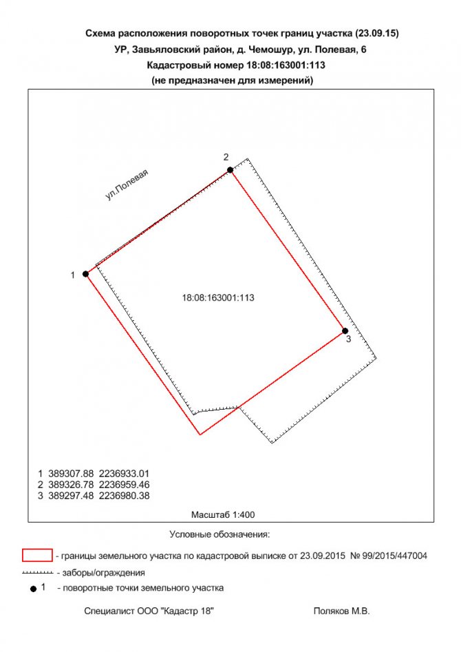
The boundaries of the site in nature and on the cadastral map (plan) are drawn according to the locations of the turning points of the land plot boundaries. That is, in places where the border line seems to break, changing direction at an angle or creating a roundness. Here a label is placed in the form:
- Boundary sign on the ground.
- Topographic sign on a map (plan).
Installed signs are formalized, indicating the coordinates of their location. Information about coordinates is entered into the GKN information bank in the form of a table , with a detailed description.
Registration card for entering information on land in the electronic database of the land cadastre.
Catalog of coordinates of boundary signs and restricted zones.
By ensuring the safety of this information, Rosreestr will always be able to identify the occurrence of an error and the overlap of memory boundaries. The regulations for the description and storage of this information are regulated by law (221-FZ) and are of significant importance for the entire land use process. Since using these points it is always possible to restore or double-check the legality of the use of the boundary territory by the owner or other title holder .
Turning points with established boundary signs must be transferred to the owner of the land plot by deed, with proof of receipt by a personal signature.
The act of establishing and agreeing on the boundaries of a land plot.
Advantageously, the pricing of boundary work on a site is regulated by the number of turning points , and their number depends on the shape and configuration of the landfill.
For example, standard plots of a straight geometric shape consist of four such points. The more complex the configuration, the more turns and bends are provided. And to accurately establish boundaries, their placement as precise as possible is required.
What are the coordinates of turning points and how to determine them?
Any plot of land has boundaries, and its configuration is fixed by a specialized line on the cadastral plan.
If the territory in certain places has bends and turns or its perimeter changes direction at an angle, forms a roundness, the change in direct movement on these sections of the border is fixed by boundary markers or topographic signs on the cadastral plan (map), which are the coordinates of turning points on the ground. These markers in the form of boundary signs installed at turning points are prohibited from being removed or changed in their location.
Thus, the coordinates of turning points are entered with a detailed description into a special table located in the information bank of the State Real Estate Cadastre.
To enter, a standard registration card is used, with the help of which the boundaries of a certain territory must be entered into the electronic database of the land cadastre, and the data is also recorded in the catalog of coordinates of boundary signs and restrictions. Using the information stored in these documents, it will not be difficult to identify errors and violations of the boundaries of the site by the owner or his neighbors.
Rosreestr is responsible for information recorded by these methods, and the legality of entry, correctness of description and rules for storing data are regulated by Federal Law No. 221.
About keypoints
A characteristic point of the boundary of a land plot is a designation that helps determine the boundary line of a separate territory; it is at these points that boundary signs are installed.
The location of characteristic points is recorded in the survey file, which is transferred by the cadastral engineer to the State Real Estate Cadastre (GKN).
This helps to highlight the location of the site on the ground, separating it from the rest of the areas surrounding it, and also to record the person or persons who own the territory or parts of it.
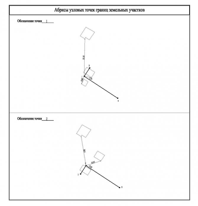
Nodal outlines
The section “Outlines of land plot boundary points” is included in the boundary plan in the case when the plots have contact coordinates that are common to three or more plots (nodal points) and within a radius of 40 m from the nodal point there are three or more terrain elements (power line supports , buildings, structures and their elements).
Determining coordinates
The presence of turning points on the plan allows you to reliably fix the boundaries. In those places where the boundary of the territory bends, losing the shape of a straight line, and where the lines turn, characteristic points are placed.
Turning points
The cadastral engineer, having completed an application to remove the boundaries of the land plot in kind, begins to prepare the technical specifications, which, in the future, will be used by surveyors to work on the ground.
To compile it you need:
- obtain an extract from Rosreestr;
- study the map (plan) of the storage facility;
- find out where the turning points are located in the surrounding areas;
- determine where these marks will be located on the perimeter.
At the next stage, surveyors, working on the ground, carry out the following actions:
- carrying out topographic measurements;
- checking the correctness of the land plot plan;
- fixing the locations of the planned turning points (arrangement of pegs).
Next, the cadastral engineer checks the work performed and also receives a report with measurements from surveyors. Having checked the correct location of the turning points, he draws the boundaries of the land plot.
Determining boundaries by coordinates
After the boundaries of the site are determined on the plan, they are taken out into the area, while separating the land area from the space that is no longer part of it. Cadastral work is carried out both on the ground and on the land plan.
Guided by the technical specifications, which contain all the data on the boundaries of the site, preliminary markings are carried out, after which the land survey lines are determined.
Sequence of cadastral works on the ground:
- At the turning points noted in the technical specifications, either permanent signs with plates or temporary signs (pegs) are placed;
- Lines are drawn between the pegs, building the contour of the boundary line;
- The surveyor ensures that the line between the pegs remains level, because if the line is drawn incorrectly, it may be displaced on the ground.
After all of the above actions, the boundary boundaries of the site indicated on the diagram are checked with the territory line on the ground. An electronic report is sent to Rosreestr, and the customer receives a boundary plan on paper. The type of boundary plan depends on the purpose of the survey.
How to determine the boundaries of a land plot by coordinates?
Determining coordinates
After completing the application for the removal of boundaries in kind, the cadastral engineer begins the preparatory stage, which consists of:
- from receiving an extract from Rosreestr;
- studying the location of turning points in adjacent areas;
- studying the plan map;
- pre-planning the placement of turning points.
Application for carrying out land surveying work.
The actions taken are included in the terms of reference, according to which, at the next stage, surveyors work on the ground:
- Topographic measurements are carried out.
- Verify the correctness of the previously drawn up plan for the location of the storage unit.
- Pegs are placed at the planning points for turning points.
Technical specifications for performing cadastral surveys.
The cadastral engineer verifies the correctness of the work being carried out and receives from surveyors the results of the measurement actions carried out in the form of a report . At the last stage, he rechecks the information about the placement of turning points and draws the boundaries of the memory.
Land survey report.
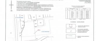
Outlines of nodal points of land boundaries
Separately, when creating a boundary plan of a land plot, such a concept as an outline is used. Under its definition lies a list of data on the location of these points on the site, which can be changed or clarified directly on the ground and such an action may be associated with their binding to certain solid elements.
Such data is presented as a separate part (section) of the boundary plan and must be reflected in the following situations:
- in the event that during the formation of one or several plots through their division, allocation, redistribution, a new point is formed that is related to a large number of adjacent plots (at least three);
Example of outlines - in situations where, through the implementation of cadastral work related to the clarification of data on the position of the border, in parallel with such an action, data on the location of a point on coordinates that is common to at least three separately located but adjacent areas is clarified.
There is one peculiarity regarding outlines - they are compiled exclusively for points that are new and must contain at least three terrain objects within a radius of up to 40 meters.
Such objects must be durable in nature and clearly and easily identifiable. For example, these may include construction sites, buildings and permanently installed structures of a non-temporary nature, supports of power lines passing close to areas.
Also, when installing outlines, the following features should be taken into account:
- the outlines indicate the distance values from the most established point to the objects to which they are attached;
- each nodal point is subject to entering data about its coordinates separately;
- on one drawing sheet it is allowed to place outlines relative to several nodal points.