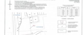
Reasons for imposing boundaries
The emergence of problems with the boundaries of land plots is explained by objective and subjective circumstances.
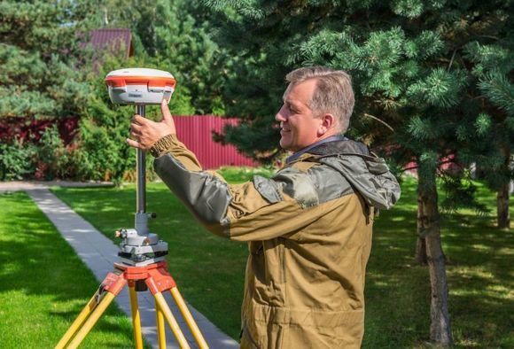
1. Objective. The general coordinate system in the Russian Federation began to operate only in 2011 after the Government of the Russian Federation adopted Resolution No. 1463 of December 28, 2012. The regulatory document approved a unified geodetic system, and until this point, personnel engineers used conventional coordinate systems. When refining a position, boundary overlaps often occur due to varying accuracy. 2. Subjective. They appear due to the negative influence of the so-called human factor. They can be purely technical (typos) or complex cadastral (incorrect calculations).
Technical errors can be corrected without major problems after filing a corresponding application with the cadastral registration authority. In addition, in many cases, corrections are made without recourse during periodic documentation reviews. Such errors have almost no effect on the possible legal actions of owners with their plots. The situation is much more complicated in the case of cadastral errors. The decision can be made only in two ways: pre-trial and judicial.
Pre-trial procedure
The simplest and fastest. Changes are made after the owner submits an application to re-register the site according to a new government decree. The cadastral engineer carries out actions taking into account existing legislation, coordinates boundaries with adjacent neighbors on a voluntary basis and, after receiving the signatures of interested individuals or legal entities, prepares new documents.

Judicial order
A difficult path, the resolution of disputes is influenced by the date of cadastral registration. If the data was received in the State Property Committee after the Cadastre Law came into force, then the identified errors are corrected in accordance with paragraphs 1 and 2 of this regulatory act.
If the registration of the site was carried out before the publication of the new law, then the error can only be corrected when a new cadastral plan is prepared indicating the exact location of the boundaries. If no disputes arise with subcontractors when preparing new documents, then the error is corrected automatically based on the submitted application from the owner. In all other cases, filing a claim with the court is mandatory.

Resolution of the Supreme Arbitration Court of the Russian Federation No. VAS-11629/11 in case No. A66-235/2010 indicates that if it is revealed that the boundaries of adjacent plots overlap and it is impossible to resolve the dispute pre-trial, a special decision is sent to the cadastral supervision body. It obliges to immediately take measures to temporarily suspend the registration of a site that is disputed between several individuals or legal entities.
Judicial practice in land disputes regarding a decision in favor of the applicant
Separate records are not kept in cases related to the consideration of disputes regarding the determination of the boundaries of land plots by the courts of first instance, however, some reasons can be identified on which a decision is usually made in favor of the plaintiff:
- unauthorized seizure of part of a land property by owners of adjacent plots by arbitrarily moving the fence;
- forced clarification of the boundaries of the site due to incorrect determination of its boundaries during the initial survey and registration;
- forcing owners of adjacent plots to sign a survey act;
- detection of an error in the cadastral registration of a land property, which the registration authority refuses to correct voluntarily;
- correction of inaccuracies in determining the boundaries of the site due to insufficient competence of the cadastral engineer.
We invite you to read: Chronicle of the ban. Let's figure out why it is now so difficult to go to a rally
Any of the grounds stated by the plaintiff in the claim is insufficient to make a decision in the absence of appropriate evidence. In addition to documentary evidence of his innocence, the plaintiff has the right to declare that the court takes into account the testimony of witnesses.
Judicial practice of decisions
Based on numerous disputes, the Supreme Court of the Russian Federation, by resolution No. 58-KG15-14, recommended that all lower courts take into account the following recommendations when considering claims for the imposition of boundaries.
The actual area of the land plot is greater than that indicated in the document
The court must carefully follow the sources of the surplus land, whether an official transfer of boundaries was made to increase its area. As an addition, it is necessary to investigate whether the growth of the site is related specifically to the places where boundaries are imposed and the subject of the dispute between adjacent neighbors.
The court should be guided by the letter of the Housing and Communal Services of the RSFSR N 20-15-1-4/E9808r for 1987, which states: in the absence of documents for land allocation, the data of the primary inventory must be taken into account. It is from them that the current area of the land plot is determined, and any surpluses found are necessarily confiscated. Their further registration is carried out in accordance with the procedure established by law.
Mistakes of a cadastral engineer
All actions should be carried out only after the boundaries between adjacent areas have been agreed upon. If no agreement was made when surveying the plots and determining their boundaries, then this is recognized as a violation of the legal rights of the plaintiffs, and the cadastral engineer must be held liable, up to and including the cancellation of the certificate. A decision must be made to exclude earth coordinates from the GKN information. Experts are involved in the clarification; they determine the situation taking into account existing boundaries and after analyzing all available official documentation. When making a decision, the court must take into account the time of use of each plot, the facts of violation of the law by one of the plaintiffs and the current position of the boundaries. The decision is made in favor of the most law-abiding plaintiff.
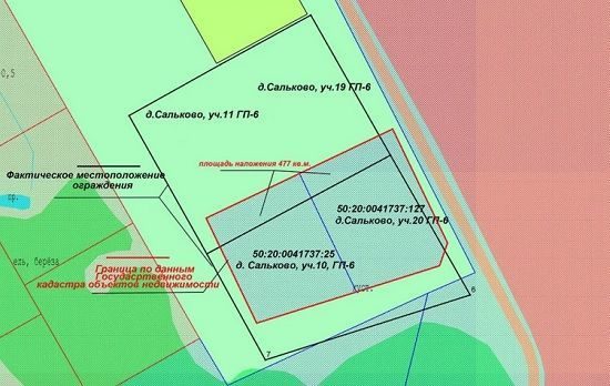
Only the boundaries of the new area overlap
The incident occurs when a new site is formed next to an existing one. If their border overlaps, then in this case preference is given to the old one. The boundaries of the new must change taking into account the actual realities on the ground. The procedure for voluntary agreement on the location of boundaries between copyright holders is a mandatory action. If it is refused, it is necessary to go to court, and pre-trial defense may put forward the following demands:
• challenge the refusal to produce cadastral documents; • oblige to enter the available information into the State Property Committee or deregister the site; • oblige to correct detected errors in existing documents.
The specific counterclaim depends on the terms of the litigation case at hand. There is no uniform decision practice; based on similar circumstances of a case, courts may make different decisions.
The influence of land management expertise
If a cadastral engineer voluntarily reported a cadastral error, then the decision to impose boundaries is made on the basis of new data. In all other cases, it is necessary to seek the help of land management expertise. Taking into account its findings, the courts can make enforceable and correct decisions. Only it makes it possible to determine all the circumstances of the case as objectively as possible:
• is there a fact of overlap of boundaries; • what area is being contested and in which direction; • reasons for the appearance of overlap; • acceptable ways to solve the problem.
The fact of the imposition of boundaries, confirmed by an expert examination, is used in making judicial decisions. The time it takes to produce cadastral documents for each plot is considered a very important factor. Preference is always given to the older ones; new registrations must take into account the actual position of the boundaries at their coordinate points.
Differences between disputes about errors and boundaries
A cadastral error is evidenced by the discrepancy between the data on boundaries in the State Property Committee and those actually on the ground. The courts take into account the objectivity and convincingness of the plaintiff’s proof of the correspondence of the documentation and nature. The subject of proof is the emerging fact of violation of the plaintiff’s rights.
Separately, cases of overlap of private boundaries with areas of the state forest fund are considered. Such disputes arise most often due to the dishonest performance of their official duties by cadastral engineers. Forest areas are large, work can take a lot of time, and boundaries are determined approximately taking into account previously done office work.
In this case, the courts must make decisions on the basis of the Federal Law “On Land Management” and paragraphs 2 and 3 of the rules of special resolution No. 688 adopted by the Government of the Russian Federation. The court appoints an expert examination and, based on its decisions, recognizes the boundaries of the plots as controversial due to insufficient regulatory accuracy in the placement of characteristic turning points. As a result, the actual location of the land plot was not established, and textured natural objects and the contours of the area were not taken into account.
The plaintiffs' demands to change existing boundaries and adjust them taking into account the latest regulatory decisions are valid and subject to mandatory satisfaction.
Judicial practice to correct cadastral errors and clarify boundaries
Judicial authorities refuse to satisfy claims regarding the invalidity of land surveying documentation, acts regarding cadastral registration, the obligation to make changes to cadastral documentation, when the requirements are based only on the fact that the applicant for a long time exploited the territory larger than the established cadastral documentation and title documents. documents, and (or) larger sizes are given in the documentation on the transfer of landholdings received before the execution of land surveying works.
The judiciary in such circumstances is guided by certain provisions. The reference to the large size of land ownership, recorded by documentation drawn up before cadastral registration, and the fact that land with the same area is fenced and exploited, is not decisive in resolving such situations due to the fact that this does not violate the rights of the applicant as owner of land recorded by the state real estate cadastre.
According to judicial practice, the actual exploitation of a larger territory violates the powers of the defendant, who owns the site used by the plaintiff. When considering such cases, an important role is played by cadastral documentation and documents that are the basis for the emergence of rights to land.
Coordination of land boundaries is also given serious importance. If the activities within the framework of this procedure were carried out on the basis of the requirements of the law, the judicial authorities refuse the requirements to clarify the boundaries for the reason that the powers of the landowner who filed the claim are not violated in this way.
The court rejected a claim filed on behalf of a gardening non-profit partnership, which sought to invalidate the registered right and restore the original boundaries of land ownership.
The state body proceeded from the fact that when carrying out boundary work on the land owned by the defendant, there were no violations of the approval procedure; the boundaries were established along the fence installed 18 years ago. In this regard, the powers of the applied partnership were not violated by land management work.
However, the courts satisfy claims regarding the exclusion from the state real estate cadastre of data regarding the coordinates, length, turning points of registered landholdings and the establishment of the boundaries of such territories in the coordinates determined by previous survey work or established during the examination, if the following points exist:
- there is documentary evidence that displays information about the applicant’s land ownership, and these documents are sufficient to establish its actual location, as well as the overlap of the boundaries of neighboring land, which was registered in the cadastral register earlier;
- during the cadastral registration of neighboring land ownership, there was a violation of the procedure for agreeing on land boundaries - there was no consent expressed by the plaintiff.
Take into account the presence or absence of an act on the file on the approval of land boundaries and on their removal to the area.
When the rights to land ownership arose on the basis of a purchase and sale transaction and the plot was legally registered in the cadastral register (the property was purchased after land surveying and cadastral registration), it will be difficult for the owner of such property to challenge the results of the survey of his land and clarify its boundaries .