Home / Real estate / Land / Cadastral registration / Cadastral number
Back
Published: June 24, 2017
Reading time: 8 min
0
457
A cadastral number is a unique set of symbols corresponding to a specific land plot. Knowing it, you can find the site on the map, look at it and its surroundings. It also allows you to obtain information about the land, such as:
- category;
- type of permitted use of the land plot;
- area and address;
- square;
- cadastral value;
- if the property is registered;
- form of ownership;
- owner;
- date of registration;
- data from the cadastral engineer who carried out the land survey;
- and so on.
The number is also indicated in land transactions, for example, purchase and sale, exchange, gift.
- Where can I get a cadastral number for a land plot? Rules for assigning a cadastral number
- Step-by-step instruction
Why do you need to get it?
The need to obtain a cadastral number for a land plot is due to the fact that:
- The presence of such a number with the owner serves as confirmation of the fact that the site is in his ownership . This makes him the full owner of his land and gives him the legal right to dispose of it at his own discretion: a purchase and sale transaction can be made with the plot, gifted to another person or bequeathed to heirs.
- It must be presented to the Federal Tax Service in order for land tax to be calculated correctly .
- The cadastral number is a means of identifying a land plot . Knowing it, an interested citizen will be able to accurately determine its size, boundaries, location, as well as the quality of the lands within the site and their purpose.
It is still possible to try to dispose of a plot that is not registered in the cadastral register, but this is not in the interests of either party to the transaction.

In this case, the potential buyer loses interest in purchasing it, since he cannot receive official confirmation of information regarding the most important characteristics of the site.
Moreover, the absence of a cadastral number may lead to disputes regarding the determination of the owner of land ownership , and municipal authorities in such a situation have the right to raise the question of recognizing it as illegally seized.
In connection with these reasons, the owner of a plot of land who has not yet received a cadastral number for it should be interested in doing this as soon as possible.
Package of documents
As already mentioned, one of the most important points when obtaining a passport for a land plot is collecting documents. The papers that will be required when applying to Rosreestr include the following:
- statement;
- a receipt confirming payment of the state duty;
- the applicant's identity card;
- a document confirming ownership of the land plot;
- the document that became the basis for the emergence of the right to the site;
- boundary plan (in some situations).
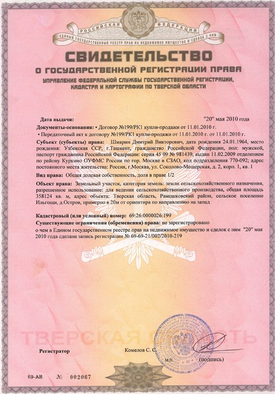
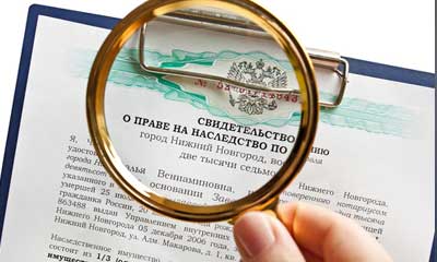
Certificate of state registration of rights to a land plot
If you have chosen the option of visiting Rosreestr in person, then after handing over the documents to the inspector, you will be provided with a receipt, which you will need to keep until the passport is issued. This receipt indicates that documents were taken from the citizen by Rosreestr employees for the designated purpose.
Reference. The application can be completed either on the computer or by hand - when considering it, this detail does not matter.
Right to land
The document confirming ownership rights to the site is one of the most important - it is the one that Rosreestr inspectors will analyze most carefully. In a nutshell, property rights allow a citizen to manage the territory based on his needs.
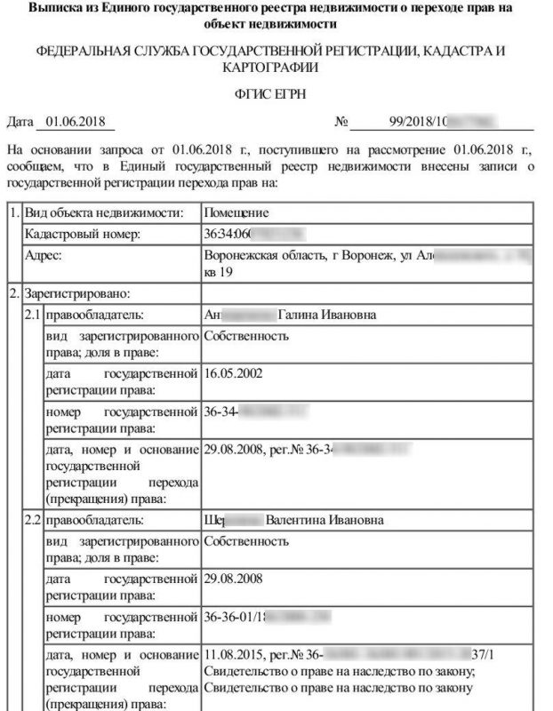
Sample extract from USRN
There are three main documents that can confirm ownership:
- certificate of ownership;
- extract from the Unified State Register of Rights;
- extract from the Unified State Register of Real Estate.
If we talk about documentation that substantiates ownership, then it includes such papers as:
- contract of sale;
- gift agreement;
- the will which transferred the land to the applicant;
- administration resolution on the transfer of the site, and so on.
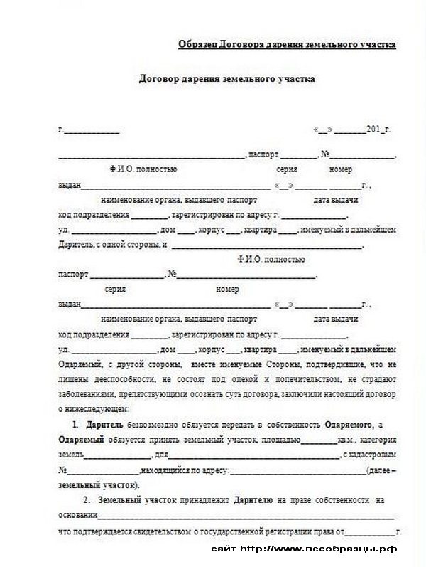
Sample land donation agreement
Land survey plan
Such a concept as a boundary plan seems unfamiliar and completely incomprehensible to many owners, and therefore we will dwell on it in more detail. A boundary plan means the division of a designated territory and the designation of its boundaries. The preparation of such a plan is preceded by the implementation of engineering and geodetic work, which is carried out by an appropriate specialist.
Reference. You can find information about certified specialists (cadastral engineers) on the official website of Rosreestr.
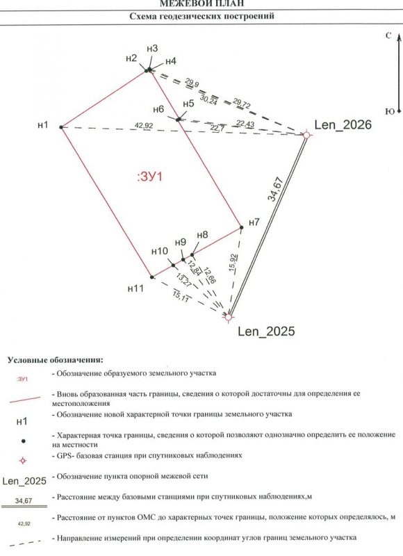
Sample boundary plan of a land plot
Also, before the engineer begins to draw up a plan, he will need information about the objects that are located in the given territory. They can be either permanent buildings or structures that are temporary. All this data must certainly be taken into account in the plan, since its legal validity depends on this. If the boundary plan does not correspond to reality, the inspectors may reject it during examination.
You can read below about in what cases a boundary plan may be required.
Why do you need a land survey plan?
State duty
The amount of the state fee paid for filing an application is directly related to the execution of the application, as well as the status of the applicant.
Table 1. Amount of state duty for obtaining a cadastral passport
| Written statement | Electronic application | |
| Individual | 200 | 150 |
| Entity | 600 | 300 |
From the table we can conclude that filing an application in electronic format is more profitable financially - the discount is 50%. However, it is recommended to use such applications for those who are confident in their abilities and can avoid all sorts of inaccuracies during registration.
Reasons for receiving
The general basis in all cases should be the fact of ownership of land if it was obtained legally .
If the land was acquired in violation of the procedures established by law, or, more simply put, appropriated, the citizen who illegally owns it cannot, except in cases established by the legislator, register it in his name and become the full owner.
to legalize a land plot and obtain a cadastral number for it based on the right of actual ownership in a situation where:
- the land was allocated for use during the years of the USSR to persons who are no longer alive at the moment, the documents for it were lost, and the procedure for re-registration of the allotment was never carried out;
- land ownership was purchased before the current legislation came into force, but there was no re-registration;
- the plot was received as if by inheritance, but this is not documented (for example, the deceased expressed his will orally);
- The settlement administration agreed to use the plot.
In the listed cases, municipal authorities often meet the needs of persons who own plots of land and use them for their own personal purposes, if this does not contradict the purpose of the land.
If the land has actually been in use for 15 years and no one has made any claims to its ownership , there should be no problems with its legalization.
In all other situations, the grounds for assigning a number to a real estate object should be considered:
- execution of a document that confirms a citizen’s rights to land;
- availability of a certificate confirming the right to inherit;
- issuance by the administrative commission of an act giving permission to use the property;
- changing the purpose of an object when land ownership should be used for other purposes;
- a court decision that was made in favor of the applicant (his extract will be required).
How is KN assigned?
These rules are defined in Section 2 of Order No. 877 of the Ministry of Economic Development dated November 24, 2015.
Let's take a closer look at them.
- A cadastral number (hereinafter - CN) must be assigned to all plots, information about which is subject to inclusion in the Unified State Register of Real Estate (USRN): in the case of the formation of a new plot , for example, when it was formed into a single whole from other plots; in the process of adding data about a previously registered site to the Unified State Register .
- CN is given to a land plot in the cadastral quarter within which it is completely located . With a large area of land ownership, it can occupy several cadastral districts. In such a situation, the cadastral number is assigned in the quarter with the accounting number “000”. The boundaries of this quarter must coincide with the boundaries of the All-Russian cadastral district. When a property is located in several cadastral districts (belonging to one cadastral district) or in several blocks of one cadastral district, it will be allocated a CN in a quarter that has the serial number “0”, the boundaries of which in this case will coincide with the boundaries of the district or district.
- If, during the process of inclusion in the Unified State Register, it is impossible to establish the cadastral quarter or area of location of an already registered object, it will be assigned a number in the quarter with the number “0”, the boundaries of which coincide with the boundaries of this area or district.
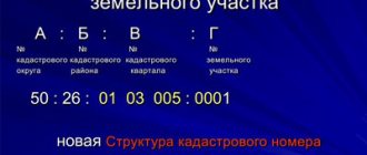
- The cadastral number must be written as decimal numbers consisting of Arabic numerals. It consists of groups of numbers separated by a colon, indicating the registration number of the cadastral quarter and the serial number of the object located on its territory.
- If a site has been deregistered, its CN cannot be used again to assign it to another object .
- Once a cadastral number has been assigned to a land plot in accordance with established rules, it is not subject to change, even in cases of changing the cadastral division or assigning a number in a quarter in which it is not located.
- If the rules for registering a CN regarding the meaning and recording of its numbers and dividing marks are violated, and also when it turns out that another object has the same number, it is assigned a new number, which must be the next in order within the cadastral quarter.
Receipt procedure
Documentation
To obtain a cadastral number, you first need to prepare the necessary documents :
- a certificate confirming land ownership or an extract from the Unified State Register of Real Estate;
- a document that is the basis for acquiring the right to use real estate (this can be a purchase and sale or lease agreement, a certificate of inheritance, a deed of gift);
- if the land ownership is located on the territory of a gardening association, a certificate of membership in this association will be required;
- if you need to rent an object from the state or municipality, you must obtain the written consent of the municipality and other tenants, if any;
- when one of the owners is a minor, it may be necessary to obtain the consent of the guardianship authority;
- a duly certified certificate of assignment of an identification code;
- technical plan;
- boundary plan;
- identification document of the interested citizen (civil passport.
The technical plan and the surveying procedure can be ordered from a geodetic company , making sure that such work is permitted by its license.
In certain situations, the owner of the land does not have the opportunity to act personally for himself. In such cases, according to the described procedure, a representative may act on his behalf, for whom it is necessary to issue a power of attorney certified by a notary.
Where is it issued?
A cadastral number can be obtained by submitting a package of documents to the local branch of Rosreestr or to the MFC .
A prerequisite is preliminary land surveying; to carry out this procedure, you will need to contact a geodetic company.
An agency official will ask the applicant to complete an application, also called a request.
Its form can be downloaded by following the link https://mfc-gosuslugi.ru/attachments/article/15/f-pril-1.doc.
Then the citizen must be given a receipt for payment of the state duty. Its size today is 200 rubles .
An employee of the institution takes the documents, in return for which he gives the applicant a receipt. It must contain a list of all transferred papers, as well as the date when you can pick up the extract with the cadastral number. If you submit an application through the MFC, you can receive the finished document there.
As of 2021, cadastral passports are no longer issued as they have been abolished. Now the applicant is given a single extract from Rosreestr.
Deadlines for preparing an extract
If there are no errors or inaccuracies in the documents, the extract will be made within 21 working days . If inconsistencies are found in the papers, this can greatly delay the procedure.
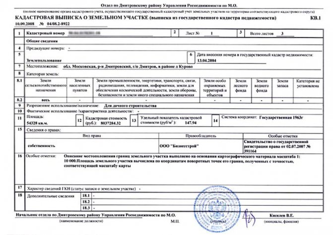
The finished extract with the cadastral number looks like this:
Online issuance
Today such an opportunity exists. To use it, you need to go to the Rosreestr website by entering https://www.rosreestr.ru in the address bar of your browser, and then going to the “Individuals” section (for citizens).

In the window that opens, on the right we find the link “State cadastral registration” and follow it.

In the form that opens, mark the items we need and move on, following the instructions displayed on the screen.
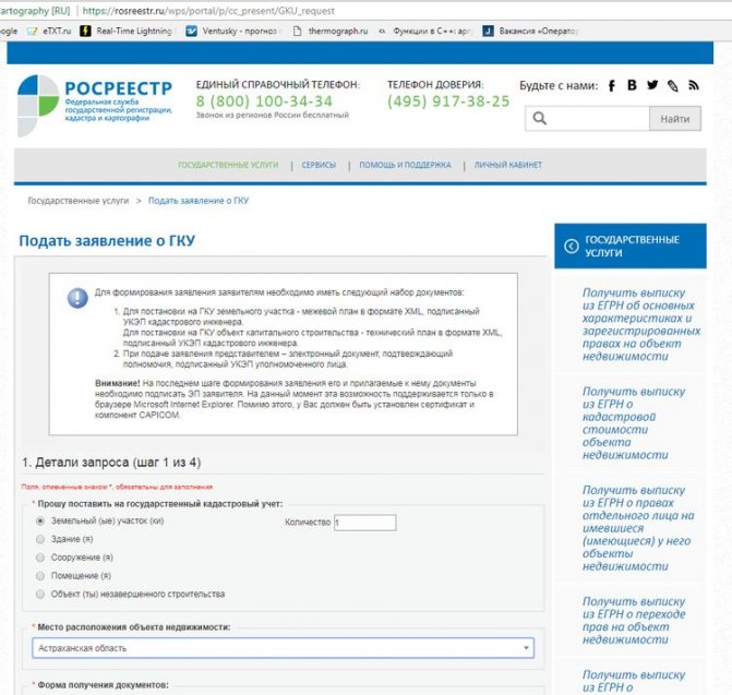
After completing all the steps (there are 4 in total), an application will be submitted to register the land plot for cadastral registration.
When the documents are ready, they can be obtained at the applicant’s choice:
- as a link to an electronic document;
- in the form of a regular paper document (in the division of the body for registration of rights, in the MFC, or by sending by mail).
You can get an extract for an already registered object by selecting the corresponding command on the right side of the window in the previous screenshot (it is the top one in the column). A page will open with a form to fill out, where you must enter the relevant information.
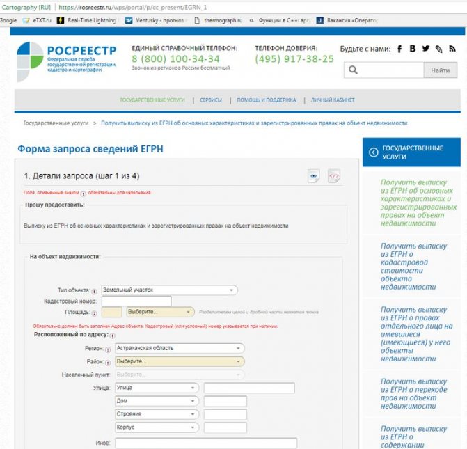
Next, you should go through 3 more steps, following the instructions.
After completing the form and confirming the entered information, the request is sent for processing.
Depending on the user's choice, the finished statement will be received :
- as a link to an electronic document;
- to the e-mail address.
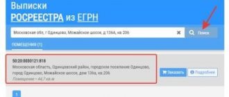
How to find out the cadastral number of a property by address?
The State Register of Real Estate is a registration body for the property of individuals and legal entities.
The accounting of land plots is formed into a single real estate database, which is publicly available on the Rosreestr website. The procedure for searching land plots on a map is a convenient mechanism for public access to state register databases. Anyone can use the service.
Many people wonder how to find out the cadastral number of a property? This requires almost no special skills. All you need is:
- Internet access (via computer or mobile device).
- Skills in searching for information on the Internet and the ability to work with an interactive map of the location of objects.
The site interface looks like a form where you need to enter the address of the site. An advanced search allows you to find any address in Russia, and then pay attention to the information tab about the object. The cadastral number of the found property will be displayed there.
Public information about a land plot helps you study an interactive map and determine the location of the territory down to the meters.
To check the location on the map, you can use one of the following methods:
- Find a plot by cadastral number or vice versa, by opening an online map on the Rosreestr website.
- Submit a paid request to search for a digital object number.
- Find out the plot number from the real estate cadastral passport.
- Take the digital number from the certificate of state registration of title (issued after receiving ownership of the property).
- Send a request to the cadastral chamber.
- Receive an extract on the cadastral characteristics of the site.
As we see, there is nothing complicated. It is enough to know what the conditional number looks like and where it can be found.
Owners of residential and non-residential premises are concerned with the question of how to find out the cadastral number of an apartment or dacha? The search procedure is identical to determining the conditional number of a land plot:
- Submitting a request through the official website of Rosreestr.
- Find out the cadastral number from the apartment owner's passport.
- Send a request to the territorial body of Rosreestr (you can obtain the number upon a personal visit to the Cadastral Chamber).
- Open the certificate of state registration of the right to the apartment and check the cadastral number.
- Send an application to extract data from the Unified State Register (this way you can find out the old cadastral number and change it to a new digital code).
A cadastral number is assigned to all real estate objects included in the state register. If a site is not in the database, then there is no way to obtain information about it.
Registration of a land plot rests with the owner himself. To do this, he needs to prepare a passport, an application, title documents and information about land surveying.
The period for consideration of applications is 18 working days, after which the owner receives a new cadastral passport, and his plot is entered into the real estate register. After this, the conditional number of the house or land becomes available for search.
A public map of real estate objects began operating on the site in 2010. The interactive resource includes a search by individual site number.
The site has incorporated updated information, as old information is replaced by new information.
This allows you to find out the cadastral number by the address on the map, even if the owner of the plot sold it to another owner.
The interactive map displays the exact dimensions of land plots, shows what the area looks like and how many houses are located nearby. Lawyers advise checking your cadastral number, and if you find any inaccuracies, report it to Rosreestr.
The proximity to other areas gives rise to a lot of contradictions between the owners of the territories. Searching the register allows you to establish the exact coordinates and sizes of plots. To do this, just enter the cadastral number in the search field and find out the area of the required land.
In some cases, it is urgent to find out information about one or more owners of an empty plot.
In order to obtain the information of interest, you need to find out the cadastral number of the plot.
If there is a house and non-residential buildings on the site, and their owner is unknown, you need to look at the cadastral numbers of the buildings on the same map, and then send a request to the Cadastral Chamber.
Federal law states that the assignment of cadastral numbers is the responsibility of Rosreestr authorities. Based on the results of the registration, the owner receives a cadastral passport, the first item of which is the individual number of the land plot.
To avoid errors in assigning cadastral numbers, it is necessary to check the conventional numbers of the certificate of ownership with the numbers indicated in the received cadastral passport. If they match, then everything is fine. Otherwise one of the numbers will be old. It is in the interests of the site owner to promptly replace the document.
We invite you to read: How to conduct occupational safety training in the workplace?
Real estate is only legally considered property when it is registered at the state level.
Entering information into the register is mandatory if the owner applies for a certificate of ownership.
A real estate property is assigned unique identification numbers that do not change for the entire existence of the property.
The owner may change when real estate transactions occur, changes and amendments are also made as necessary, but the assigned numbers remain in the state register forever. If an object ceases to exist, for example, as a result of a fire or the planned demolition of a dilapidated building, then you will need to delete their state register number, attaching documentary evidence.
The State Real Estate Cadastre of the State Property Committee contains data on millions of objects; in addition, there is a public cadastral map and an extract from the unified register. Anyone can obtain the data upon presentation of a passport and application.
For example, a citizen purchases real estate and wants to check and personally verify the purity of the transaction. Cadastre data will allow you to accurately find out information about the owner and technical data of the object, whether there are encumbrances or liens.
Symbols were assigned to real estate objects during the formation of the federal base in the period 1992-2000.
If during this period a citizen registered ownership rights to land, an apartment, a garage and other real estate objects, then the property was assigned a so-called conditional number.
This identifier also has legal significance; regional registrar authorities are responsible for its assignment.
The conditional number was assigned at the regional level; externally it consists of 6-7 groups of encrypted data.
The cadastral number externally consists of 4-6 groups of numbers separated by a colon.
The cadastre links the object to the map; an additional geographical reference to the site on which the building is located is indicated.
The conditional and cadastral numbers do not contradict each other; they represent different accounting information bases, but both display unique and relevant information.
The owner whose property has only an old conditional number is recommended to obtain a new cadastral number.
Registration of transactions with property is impossible using the old registration number; any application to Rosreestr automatically leads to the appearance of a new cadastral number.
The cadastral number determines such important information as the cadastral value of the object.
The price is required for various settlements between the state and citizens, various civil settlements.
The old numbering, previously used and assigned to objects, is represented by a digital code; divisions within the cipher are used in the form of a slash or a hyphen.
The first two digits display the federal district, then two characters provide information from the classifier based on registration characteristics.
The data is read and decrypted as follows:
- XX - code of the registrar department that assigned the number;
- XXX - serial number of the account book;
- XXXX - the year in which the entry was made;
- XXX is the serial number in the registration book for a given year.
Such accounting was logical and in demand, but the creation of a database in electronic form was not carried out. There is no unified federal accounting on electronic media for the symbolic designation of real estate objects.
This information is correct, but not needed at the moment.
When conducting a transaction, an additional cadastral number will be automatically assigned, but the second party to the transaction will not always agree to purchase the property before cadastral registration is carried out.
Initially, with new registration, you will need to create a cadastral passport for the land on which the property is located.
The principle of the new cadastre is based on reference to a map of the area.
This method identifies real estate much more accurately, since it eliminates various errors associated with the human factor.
We invite you to read: New regulations on disability
If the apartment is not assigned a cadastral number, this indicates that the privatization or acquisition took place before the start of the federal cadastre law.
The second case is that there is no information about the land plot on which the living space is located.
Every citizen who has a document on the right to own a residential property can personally or through the MFC be assigned a cadastral number.
You can register with the cadastral register calmly and without haste, it will not cost much.
Ownership documents must be in order and comply with legal requirements.
When visiting a registrar or MFC in person, a citizen must provide his passport, a document with a conditional number for the property and pay 150 rubles of state duty.
Assigning a cadastral number, if the check confirms the relevance of the data, takes 5 days.
You can use the data provided by the Rosreestr portal if you have a conditional account number.
In the “reference data” section, the existing code is entered, after processing the request, the data on the object is displayed.