Home / Real estate / Land / Land survey / Boundaries of the land / Changing the boundaries of the land
Back
Published: March 26, 2017
Reading time: 15 min
0
1602
Establishing the boundaries of a site by land surveying is an important condition not only in order to obtain the necessary documents for it, but also to determine the specific territory that can be used by the owner.
As part of the implementation of the latter goal, the boundaries of the land, fixed in documents, are also established actually, on the ground . This procedure is called drawing out the boundaries of the site and requires a more detailed consideration.
- Legislation
- The essence and purpose of the procedure Previously established boundary markers were lost
- The owner intends to erect a building or structure (including a fence) on the site
- The land has a new owner (for example, if it is purchased, leased or subleased)
- Owners of neighboring plots carry out land surveying procedures in relation to their properties
- Certain changes are taking place in relation to the site
- Search for a contractor
- Temporary
When is turning point restoration required?
The Unified State Register of Real Estate stores data about the land plot, with the help of which the location of turning points is identified, and land survey signs are installed that record the boundaries of the allotment . Let's take a closer look at what it is and why it may be necessary.
Turning points of a land plot are places where surveyors install survey signs necessary to further identify the coordinates of the territory.
According to their location, officially recorded in the technical plan and the State Property Committee, the following is established :
- location of the object or terrain;
- the person who owns the land.
installed signs at characteristic points in the absence of surveying engineers .
There are many situations in which outlining boundaries is necessary:
- Construction of a new building . Survey signs indicate the coordinates of the land plot and help determine the shape and area of the plot in order to prepare for work.
- Acquisition of territory from the previous owner. All transactions related to land carry a certain risk: the data specified in the contract does not correspond to the real parameters of the site. In order to prevent possible disputes with the owners of adjacent territories and problems with purchase and sale, it is necessary to restore the boundaries of the land plot in the area to their previous values, that is, those that were recorded in the register.
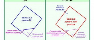
- Division of real estate between several owners. Mapping out all points of the allotment will help determine the exact limits and avoid shortcomings when making a transaction.
- Loss of land survey signs . Very often they are rearranged or lost, for which the law provides for a fine of 5 thousand rubles. The procedure for restoring boundaries will help determine the coordinates and shape of the site on the ground.
- Landscape works . When landscaping a land plot, the area and configuration of the plot are of great importance. Having installed land surveying signs, you can begin to design the territory.
The purchased property must be registered. After the data indicating the survey points are reflected in the State Property Committee, the plot will be assigned a cadastral number. After this, the plot of land is an independent unit, and the owner is its legal owner.
The procedure for restoring coordinates on the ground should be approached with all responsibility .
Due to lack of qualifications and experience, specialists make mistakes when determining the boundaries of the plot. As a result, the land survey plan and other documents contain incorrect data.
What it is?
Removal of boundaries involves the installation of boundary signs (MS), marking the boundaries of property, on a land plot. The entire list of geodetic procedures is applicable to standard landfills.
In this case, the placement of points is based on previously carried out surveying and information contained in the real estate register. If the owner does not have such information and, upon request, a negative response comes from government agencies, then in this situation the land plot is surveyed.
Setting out boundaries in nature determines the following results:
- obtaining accurate information about the plot area and shape;
- establishing boundaries that comply with regulatory documents;
- reliable determination of the location of the site on the ground and among other properties.
All this information is used to determine the value of the land plot, its features and characteristics and allow the plot to be used as efficiently as possible. In addition, when making any transactions with land, you will need documents for it.
You can get detailed information about the actions that people take when buying and selling a plot of land, including checking documents for legal purity, on the website. Ask a question to a lawyer in a special consultation window or call.
Fixing signs on the ground
Engineering and geodetic surveys are complex work that requires professionalism and qualifications on the part of the cadastral specialist who carries out the marking of the plot.
Small mistakes in land surveying can later cause serious land disputes.
Territory marking is carried out on the ground.
At the end of the topographic survey, land surveying signs - pegs - are placed.
This procedure can be carried out according to the following scheme :
- installation of standardized posts with the branded badge of the geodetic organization;
- marking using simple wooden stakes;
- installation of temporary columns, with further replacement with permanent metal pipes.
Differences in the procedure are due to the status of the geodetic organization, as well as the value of real estate in the general area, where land disputes arise over every meter.
Permanent signs are needed to restore boundaries when surveying large territories , where small plots can simply get lost and go unnoticed.
According to the standards, boundary markers must be made of reliable material with standard parameters :
- sign length – from 80 cm;
- diameter of stakes – 5-15 cm.
To prevent theft of poles, you can use anti-vandal products . They are made of metal and are slightly smaller in size than usual. The main advantage of such signs is that the base, located in the ground, is made in the form of an anchor. And it will be very difficult to move such pillars.
Methods of measurement and progress of work on removing boundaries
With the development of technology and the introduction of GLONASS/GPS, GPS points have become the most common method for delineating boundaries on the ground. They are placed at the corners of the site according to the coordinates indicated in the boundary plan, after which other measurements are taken.
Preparatory stage
First, the cadastral engineer gets acquainted with the documentation for the site: a boundary or technical plan, which indicates the features of the terrain, elevation changes, the nature of the soil, the length of each side and the total area. Particular attention is paid to the coordinates of turning points, according to which GPS points will be placed.
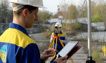
Field work
This is a direct visit to the area.
The engineer sets up GPS points and marks them with short-term or permanent signs. It is preferable to install permanent signs, but this is not always possible on site. More often, this type of GPS boundary marking is used when delineating agricultural land boundaries. Externally, a permanent sign is attached to a dug and concreted post. Such tags remain undamaged during agricultural work, are highly resistant to bad weather, and cannot be moved. If possible, permanent GPS tags can be placed on a summer cottage or on an area for individual housing construction. The number of marks is determined by the number of corners of the area. If it has uneven edges, using the obtained points you can draw a fence strictly according to the shape of the land plot.
Office stage
The result of work on the removal of boundaries in kind becomes a Certificate of Work Completed. For 2021, it is compiled by a geodetic company in free form. The paper must contain:
- information about the owner of the site or the customer of the work;
- information about the contractor - the office that placed the marks;
- data on the location of the site on the ground relative to other land plots, its shape, size, characteristic features;
- the reason for carrying out work to remove the site;
- results of the work: in what form are the markers installed on the ground.
- Additionally, the following information may be provided:
- measurement method and technical characteristics of the instruments used;
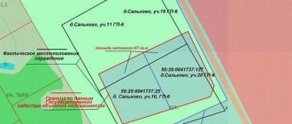
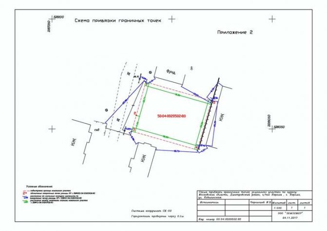
- graphic information: diagram, cartographic marks. This visual part of the document contains an illustration of the area plan, and even photographs of the land plot and installed markers are possible.
The act is usually drawn up in two copies, both containing the date and signatures of the receiving party and the contractor who made the changes.
Stages of work
Cadastral surveys are carried out on the basis of land management technical documentation to determine the boundaries of a land plot, developed and approved by current legislation.
The complex of engineering and geodetic services involves several stages:
- Preparatory work : coordination of deadlines, cost of cadastral surveys; preparation of initial data; requesting information from the State Property Committee for an object whose characteristic points are planned to be taken into nature.
- Field stage : departure of specialists for reconnaissance; topographic survey to establish the coordinates of the site; fixing survey points on the ground with their markings.
- Desk stage : documentary processing of the received data, equalization of measurements; signing acts of transfer and acceptance of supplied land survey signs; preparation of a technical report on engineering and geodetic work to restore points on the ground (production of an outline depicting the real boundaries of the territory with located land survey signs).
After the limits are set, the owner of the land plot is given a fully formed package of documents .
The list of papers based on the results of geodetic surveys includes:
- An explanatory certificate indicating information about the contractor, details of permitting documentation, information about the owners of adjacent land plots, a brief description of the work.
- Terms of reference for carrying out the procedure for setting out boundaries.
- A duplicate of the identity card of the executor-surveyor or a certificate of a legal entity.
- Photocopies of title documentation.
- Materials of geodetic field surveys.
- List of possible prohibitions regarding the operation of the allotment.
- A technical plan of the boundaries of the site, formed on the basis of topographic photography, indicating characteristic points, external limits, linear distances, data on the owners of adjacent plots and the owner of the object.
- Power of attorney, if a representative of the interested party participates in the procedure.
- The act of transferring and accepting land surveying signs for storage to the owner of the land.
When receiving documents based on the results of setting out boundaries, you should ensure that the engineer submits all the certificates listed in this list. The documents must bear the signature of the performer and his seal .
How does boundary removal occur?
Before submitting an application for removal in kind, it is necessary to prepare a package of documents that the owner usually has:
- cadastral passport;
- title document for land;
- boundary work (if any).
After receiving this package, cadastral engineers begin work. Realization consists of several successive stages:
- Preparation and analysis of documents, including for possible restrictions.
- A surveyor travels to the site, takes measurements and determines the coordinates of turning points.
- Desk processing of received data, drawing up a report.
- Installation of boundary signs at turning points of the land plot.
Topographical work is carried out in the presence of the customer: the owner or realtor. At the appointed time, they meet with the survey engineers at the site. The established boundary signs are transferred to the land owner according to the acceptance certificate. Ideally, each of them has its own unique number and an indication of the organization that carried out the work. This will allow you to refer to the results of the boundary removal in the future if doubts or disputes arise.
The main document that the customer receives is the act of taking out in kind. It includes all the information that was established during geodetic work. Namely:
- specified area of ownership;
- location on the ground indicating topographical data;
- coordinates of each boundary sign at turning points;
- exact location and characteristics of the boundaries of the site.
Along with the act, the customer receives other documents:
- a copy of the registration certificate of the geodetic organization or a document confirming the identity of the engineer who carried out the work;
- terms of reference for the work;
- a copy of documentary evidence of land ownership;
- information about the restrictions established for this area;
- an explanatory note indicating who carried out the work and when (with license numbers), information about the site, its owner, adjacent territories, etc.
- topographic plan of boundaries with measurements;
- act of acceptance and transfer of boundary markers to the land owner for storage.
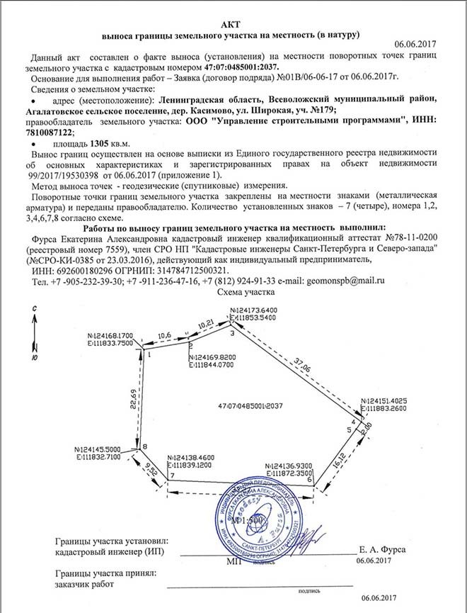
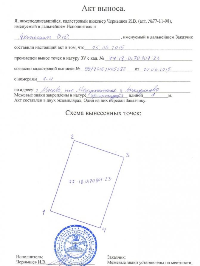
Samples of points restoration acts
This type of document confirms the fact that the points of the real estate property have been taken out into nature. In various situations, a certain form of certificate may be required.
Simple
The document is drawn up in free form . Each company has its own specific forms (this is not prohibited by law).
The act must contain the following information :
- data from the Unified State Register of Real Estate, which serves as the basis for carrying out work;
- allotment dimensions;
- location;
- scheme of land survey markers;
- information about the owner of the site.
The act is drawn up in several copies - for the customer, the performer and endorsed with their signatures. Often the document is supplemented with a photo.
With photo report
Although this is an official document, it is not proof . The boundary markers could have been moved, destroyed or moved.
There are several ways out of this situation :
- carrying out the procedure in the presence of neighbors who will put their signatures on the document;
- photographic recording of the surveys performed and preparation of a detailed certificate.
A reference document with a photo report must include : an explanatory note, a plan for the location of characteristic points, a list of coordinates, photos of marked signs.
With binding scheme
In addition to the photo report, the act contains a drawing that displays all permanent buildings located more than 20 m from the boundaries of the allotment, and measurements from these buildings to boundary markers. Also attached to the document is a surveyor’s certificate, certificate and verification of the equipment used.
The act is endorsed by a seal and signature of the engineer.
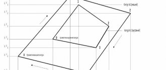
Sample binding diagram:
If the land plot is located in the middle of a large field, the act will not have any effect. It is used only when taking measurements on existing territories .
Land survey
The removal of boundaries is confirmed by a specialist’s examination, issued in the form of a conclusion . In it, the engineer draws up a full answer about the surveys performed, attaches photos, and provides answers to questions of interest regarding the compliance of the actual limits of the land plot with those reflected in the extract.
The act is endorsed by the company's seal and the signature of the surveyor.
What is the accuracy of determining boundary signs?
The actual error in determining the boundaries of a land plot on the ground does not exceed 5 centimeters relative to the points of the state geodetic network (GGS) - this is the accuracy that modern geodetic instruments currently provide. The accuracy of determining the coordinates of the turning points of the boundaries of the land plot (with what accuracy the plot is placed on cadastral registration) is indicated in the extract from the Unified State Register of Real Estate. Values usually range from 10 to 30 cm.
That is, the accuracy of our work is 5 cm (relative to the coordinates indicated in the extract), and the accuracy of the coordinates indicated in the extract is 10-30 cm. As a result, the maximum error in determining the location of boundary signs when staking out the boundaries of the site does not exceed the value of the error in determining coordinates during its surveying.
Deadlines
The time for placing points on the ground is agreed upon before concluding the contract. The timing may vary for different performers. Typically, surveys are completed within 10-15 days .
Some organizations guarantee completion of engineering surveys within a month. For urgency, additional financial compensation is established.
After the boundaries are restored on the ground, it will take several days to draw up the act . The work itself can be completed within 24 hours; the remaining time will be required to generate an extract from the unified real estate register.
Price

Organizations offer a basic set of services, including the removal of 4 boundary markers and registration of an act on the ground. The average price is 9,000 rubles .
Each additional type of research involves a separate reward :
- removal of 5 markers – from 1 thousand rubles;
- execution of an act with a photo report – from 3 thousand;
- certificate with photo and schematic image - from 6 thousand rubles.
Also, the cost of engineering and geodetic surveys depends on the complexity of the work and cannot be fixed.
Possible problems
The main difficulty that a property owner may encounter is the wrong choice of surveyor . This issue must be approached seriously: carefully study the organization, become familiar with its reputation, and establish the presence of an SRO certificate.
An illiterate specialist may incorrectly determine the coordinates of the plot, which will result in land disputes between the owners of adjacent plots (seizure of land or loss of their part of the land plot).
Where to turn - who does the removal of boundaries?
Setting out the boundaries of a site in nature is geodetic work. At the same time, both a cadastral engineer and a surveyor can perform it. The main attribute for the removal will be geodetic equipment, which will allow the points to be determined with appropriate accuracy using the available coordinates. Therefore, in order to order the removal of the boundaries (points) of a land plot in kind, you should contact a geodetic or cadastral company, which you can select using the online catalog of land cadastral work performers, and the land cadastral work calculator will help you calculate the cost of their services online. Based on the initial data you entered (region, number of turning points), the calculator will form a selection of verified specialists and indicate the cost of their services.